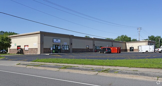
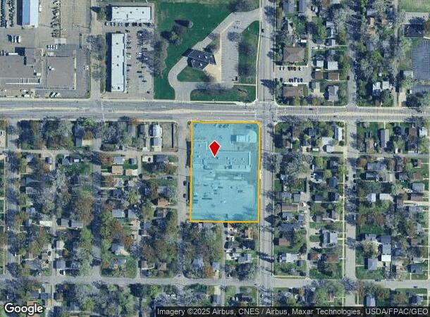
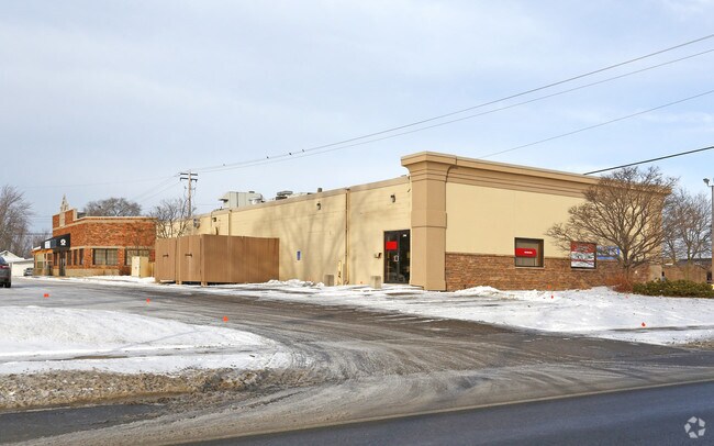
Property Record
3310 3Rd St N, Saint Cloud, MN 56303

NEARBY LISTINGS FOR SALE OR LEASE
Property Detail
3310 3Rd St N
Minneapolis/St Paul
Cottage Place Add
St. Cloud, MN
LOTS 1-18 & LOTS 29-34 BLK 1 & VAC ALLEYS ADJ SAID LOTS COTTAGE PLACE ADD SECTION 16 TOWNSHIP 124 RANGE 028 COTTAGE PLACE ADD
82.46163.0000
Stearns
Multifamilydwelling
Minnesota
2025
m
2025
2.34 AC
000601
Stearns County
26,926 SF
DEMOGRAPHICS near 3310 3Rd St N
1 Mile
3 Mile
5 Mile
2024 Total Population
8,519
67,864
109,388
2029 Population
8,848
70,200
113,039
Pop Growth 2024-2029
+ 3.86%
+ 3.44%
+ 3.34%
Average Age
38
37
37
2024 Total Households
3,541
27,017
43,676
HH Growth 2024-2029
+ 4.01%
+ 3.59%
+ 3.38%
Median Household Inc
$53,248
$53,116
$55,592
Avg Household Size
2.30
2.30
2.30
2024 Avg HH Vehicles
2.00
2.00
2.00
Median Home Value
$138,829
$180,476
$195,947
Median Year Built
1960
1980
1985
Nearby Places
Map Layers
Map Styles
 Street
 Aerial
- Restaurants
- Banks
- Shops
- Fitness
- Groceries
PUBLIC TRANSPORTATION
COMMUTER RAIL
St. Cloud Amtrak Station (Empire Builder - Amtrak)
DRIVE
WALK
Distance
St. Cloud Amtrak Station (Empire Builder - Amtrak)
6 min
2.8 mi
Freight Ports
Port Milwaukee
DRIVE
WALK
Distance
Port Milwaukee
450 min
404.9 mi
SALE & LEASE HISTORY
LISTING DATE
SALE/LEASE

Sep 25, 2016
For Lease
Sep 23, 2016
For Sale
Nearby Properties
Address
Land Use
TOTAL SIZE
Lot Size
Zoning
Address
Land Use
TOTAL SIZE
Lot Size
Zoning
16.60 AC
MD
Address
Land Use
TOTAL SIZE
Lot Size
Zoning
38.97 AC
Address
Land Use
TOTAL SIZE
Lot Size
Zoning
639,000 SF
216.67 AC
PUD28
Address
Land Use
TOTAL SIZE
Lot Size
Zoning
113,316 SF
31.99 AC
Address
Land Use
TOTAL SIZE
Lot Size
Zoning
107,306 SF
2.11 AC
C4
Address
Land Use
TOTAL SIZE
Lot Size
Zoning
105,833 SF
4.61 AC
C4
Address
Land Use
TOTAL SIZE
Lot Size
Zoning
157,266 SF
0.94 AC
R2
Address
Land Use
TOTAL SIZE
Lot Size
Zoning
238,920 SF
5.40 AC
R3
Address
Land Use
TOTAL SIZE
Lot Size
Zoning
281,127 SF
3.10 AC
PUD95
Address
Land Use
TOTAL SIZE
Lot Size
Zoning
70,971 SF
11.40 AC
PUD57
Address
Land Use
TOTAL SIZE
Lot Size
Zoning
365,299 SF
28.68 AC
R1
Address
Land Use
TOTAL SIZE
Lot Size
Zoning
177,951 SF
8.26 AC
R3
Address
Land Use
TOTAL SIZE
Lot Size
Zoning
125,278 SF
11.01 AC
C5
Address
Land Use
TOTAL SIZE
Lot Size
Zoning
152,055 SF
2.33 AC
R3
Address
Land Use
TOTAL SIZE
Lot Size
Zoning
10.46 AC
Address
Land Use
TOTAL SIZE
Lot Size
Zoning
344,031 SF
64.88 AC
PUD28
Address
Land Use
TOTAL SIZE
Lot Size
Zoning
165,758 SF
3 AC
R3
Address
Land Use
TOTAL SIZE
Lot Size
Zoning
184,285 SF
13.37 AC
Address
Land Use
TOTAL SIZE
Lot Size
Zoning
628,000 SF
40.51 AC
PUD16
Address
Land Use
TOTAL SIZE
Lot Size
Zoning
115,298 SF
8.50 AC
R5
Address
Land Use
TOTAL SIZE
Lot Size
Zoning
5.34 AC
Address
Land Use
TOTAL SIZE
Lot Size
Zoning
233,354 SF
7.30 AC
R5
Address
Land Use
TOTAL SIZE
Lot Size
Zoning
158,809 SF
2.67 AC
R3
Address
Land Use
TOTAL SIZE
Lot Size
Zoning
232,274 SF
2.94 AC
R3
Address
Land Use
TOTAL SIZE
Lot Size
Zoning
113,268 SF
12 AC
PUD32
Address
Land Use
TOTAL SIZE
Lot Size
Zoning
19.83 AC
Address
Land Use
TOTAL SIZE
Lot Size
Zoning
157,500 SF
1.25 AC
C3
Address
Land Use
TOTAL SIZE
Lot Size
Zoning
15.78 AC
Address
Land Use
TOTAL SIZE
Lot Size
Zoning
105,123 SF
36.87 AC
R1
Address
Land Use
TOTAL SIZE
Lot Size
Zoning
183,627 SF
3 AC
R3
The World's #1 Commercial Real Estate Marketplace
Connect with us
© 2026 CoStar Group
The information above has been obtained from sources believed reliable. While we do not doubt its accuracy we have not verified it and make no guarantee, warranty or representation about it. It is your responsibility to independently confirm its accuracy and completeness. Any projections, opinions, assumptions, or estimates used are for example only and do not represent the current or future performance of the property. The value of this transaction to you depends on tax and other factors which should be evaluated by your tax, financial, and legal advisors. You and your advisors should conduct a careful, independent investigation of the property to determine to your satisfaction the suitability of the property for your needs.