Property Record
3310 45Th St, Two Rivers, WI 54241
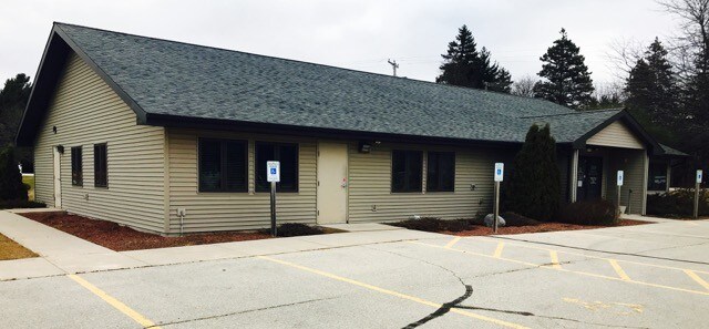


Property Detail
3310 45Th St
053-226-203-001.07
S 1/2 NW 1/4 S26 T20N R24E TRACT 1 OF CSM V 14 P 9
Commercialnec
Manitowoc
B2
Wisconsin
B and X Area of moderate flood hazard, usually the area between the limits of the 100-year and 500-year floods.
1.16 AC
2024
Wisconsin South Area
2024
Other Market Areas
005200
Manitowoc, WI
8,909 SF
NEARBY LISTINGS FOR SALE OR LEASE
DEMOGRAPHICS near 3310 45Th St
1 mile
3 mile
5 mile
2025 Total Population
2,402
12,565
18,845
2030 Population
2,380
12,603
18,943
Pop Growth 2025-2030
(0.92%)
+ 0.30%
+ 0.52%
Average Age
47
45
45
2025 Total Households
1,077
5,701
8,629
HH Growth 2025-2030
(1.02%)
+ 0.33%
+ 0.53%
Median Household Inc
$71,898
$58,967
$63,497
Avg Household Size
2.20
2.10
2.10
2025 Avg HH Vehicles
2.00
2.00
2.00
Median Home Value
$198,498
$162,854
$177,992
Median Year Built
1968
1959
1965
Nearby Places
Map Layers
Map Styles
 Street
 Aerial
Layers
 Traffic
 Biking
Places
Listings with unknown addresses are not visible on the map
- Restaurants
- Banks
- Shops
- Fitness
- Groceries
SALE & LEASE HISTORY
LISTING DATE
SALE/LEASE

Dec 12, 2017
For Sale
Nearby Properties
Address
Land Use
TOTAL SIZE
Lot Size
Zoning
Address
Land Use
TOTAL SIZE
Lot Size
Zoning
39.74 AC
I3
Address
Land Use
TOTAL SIZE
Lot Size
Zoning
30.22 AC
I2
Address
Land Use
TOTAL SIZE
Lot Size
Zoning
33,012 SF
1.11 AC
B1
Address
Land Use
TOTAL SIZE
Lot Size
Zoning
164,517 SF
10.71 AC
IPF
Address
Land Use
TOTAL SIZE
Lot Size
Zoning
638,600 SF
20.47 AC
I2
Address
Land Use
TOTAL SIZE
Lot Size
Zoning
83,486 SF
3.82 AC
B2
Address
Land Use
TOTAL SIZE
Lot Size
Zoning
20,696 SF
2.27 AC
B1
Address
Land Use
TOTAL SIZE
Lot Size
Zoning
52,033 SF
2.19 AC
R4
Address
Land Use
TOTAL SIZE
Lot Size
Zoning
45,048 SF
1.35 AC
B1
Address
Land Use
TOTAL SIZE
Lot Size
Zoning
37,703 SF
1.76 AC
R4
Address
Land Use
TOTAL SIZE
Lot Size
Zoning
6.19 AC
I2
Address
Land Use
TOTAL SIZE
Lot Size
Zoning
3,700 SF
5.06 AC
R3
Address
Land Use
TOTAL SIZE
Lot Size
Zoning
90,778 SF
3.51 AC
B1
Address
Land Use
TOTAL SIZE
Lot Size
Zoning
45,360 SF
1.75 AC
PUD
Address
Land Use
TOTAL SIZE
Lot Size
Zoning
46,080 SF
2.01 AC
PUD
Address
Land Use
TOTAL SIZE
Lot Size
Zoning
34,578 SF
0.62 AC
PUD
Address
Land Use
TOTAL SIZE
Lot Size
Zoning
9,776 SF
1.14 AC
OSB
Address
Land Use
TOTAL SIZE
Lot Size
Zoning
5.39 AC
I1
Address
Land Use
TOTAL SIZE
Lot Size
Zoning
29,268 SF
1.36 AC
R3
Address
Land Use
TOTAL SIZE
Lot Size
Zoning
46,800 SF
2.06 AC
I2
Address
Land Use
TOTAL SIZE
Lot Size
Zoning
41,256 SF
0.94 AC
R4
Address
Land Use
TOTAL SIZE
Lot Size
Zoning
12.25 AC
I2
Address
Land Use
TOTAL SIZE
Lot Size
Zoning
64,062 SF
3.56 AC
R4
Address
Land Use
TOTAL SIZE
Lot Size
Zoning
5.29 AC
I2
Address
Land Use
TOTAL SIZE
Lot Size
Zoning
31,204 SF
0.90 AC
PUD
Address
Land Use
TOTAL SIZE
Lot Size
Zoning
38,947 SF
3.13 AC
B2
Address
Land Use
TOTAL SIZE
Lot Size
Zoning
35,356 SF
1.29 AC
PUD
Address
Land Use
TOTAL SIZE
Lot Size
Zoning
4.39 AC
I2
Address
Land Use
TOTAL SIZE
Lot Size
Zoning
93,600 SF
3.87 AC
I2
Address
Land Use
TOTAL SIZE
Lot Size
Zoning
28,324 SF
0.94 AC
PUD
The World's #1 Commercial Real Estate Marketplace
Connect with us
© 2026 CoStar Group
The information above has been obtained from sources believed reliable. While we do not doubt its accuracy we have not verified it and make no guarantee, warranty or representation about it. It is your responsibility to independently confirm its accuracy and completeness. Any projections, opinions, assumptions, or estimates used are for example only and do not represent the current or future performance of the property. The value of this transaction to you depends on tax and other factors which should be evaluated by your tax, financial, and legal advisors. You and your advisors should conduct a careful, independent investigation of the property to determine to your satisfaction the suitability of the property for your needs.