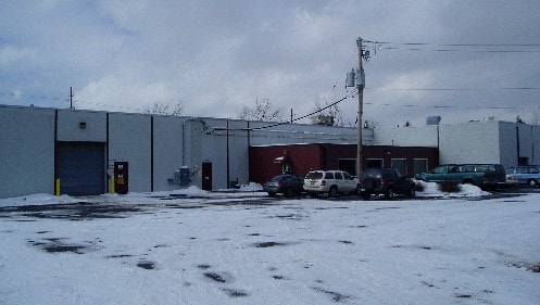
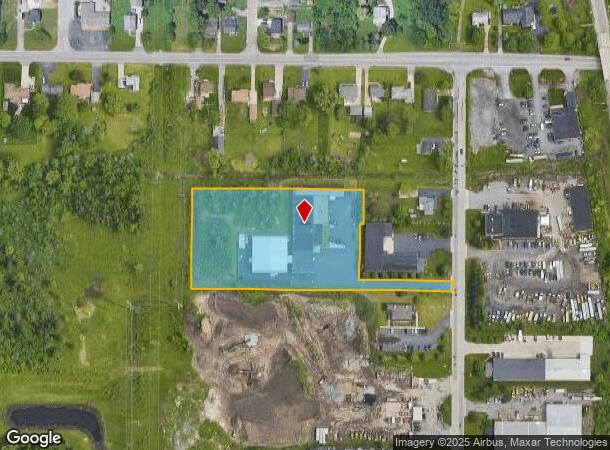
Property Record
3310 N Benzing Rd, Orchard Park, NY 14127
NEARBY LISTINGS FOR SALE OR LEASE
Property Detail
3310 N Benzing Rd
146089-152-130-0003-025-000
Erie
Warehouse
New York
X
25.000
36029C0342H
3.43 AC
2025
South
2024
Buffalo/Niagara Falls
013701
Buffalo-Cheektowaga-Niagara Falls, NY
22,592 SF
DEMOGRAPHICS near 3310 N Benzing Rd
1 Mile
3 Mile
5 Mile
2024 Total Population
3,672
56,078
147,334
2029 Population
3,662
55,729
145,783
Pop Growth 2024-2029
(0.27%)
(0.62%)
(1.05%)
Average Age
43
43
43
2024 Total Households
1,574
24,633
63,770
HH Growth 2024-2029
(0.25%)
(0.70%)
(1.12%)
Median Household Inc
$83,916
$68,636
$65,719
Avg Household Size
2.30
2.20
2.20
2024 Avg HH Vehicles
2.00
2.00
2.00
Median Home Value
$181,279
$191,746
$188,866
Median Year Built
1961
1963
1960
Nearby Places
- Restaurants
- Banks
- Shops
- Fitness
- Groceries
PUBLIC TRANSPORTATION
AIRPORT
Buffalo Niagara International
DRIVE
WALK
Distance
Buffalo Niagara International
27 min
15.7 mi
Niagara Falls International
DRIVE
WALK
Distance
Niagara Falls International
48 min
30.8 mi
Nearby Properties
Address
Land Use
TOTAL SIZE
Lot Size
Zoning
Address
Land Use
TOTAL SIZE
Lot Size
Zoning
49,500 SF
108.40 AC
R1
Address
Land Use
TOTAL SIZE
Lot Size
Zoning
22,754 SF
41.80 AC
Address
Land Use
TOTAL SIZE
Lot Size
Zoning
183,334 SF
50.90 AC
B2
Address
Land Use
TOTAL SIZE
Lot Size
Zoning
197,584 SF
32.50 AC
B2
Address
Land Use
TOTAL SIZE
Lot Size
Zoning
48.14 AC
OP
Address
Land Use
TOTAL SIZE
Lot Size
Zoning
43,942 SF
14.34 AC
CBD
Address
Land Use
TOTAL SIZE
Lot Size
Zoning
115,317 SF
17.87 AC
DR
Address
Land Use
TOTAL SIZE
Lot Size
Zoning
124,112 SF
53.10 AC
05 - COMME
Address
Land Use
TOTAL SIZE
Lot Size
Zoning
149,065 SF
21.53 AC
B2
Address
Land Use
TOTAL SIZE
Lot Size
Zoning
205,680 SF
37.40 AC
11
Address
Land Use
TOTAL SIZE
Lot Size
Zoning
59,421 SF
75.40 AC
B1
Address
Land Use
TOTAL SIZE
Lot Size
Zoning
202,597 SF
24.22 AC
Address
Land Use
TOTAL SIZE
Lot Size
Zoning
0.07 AC
Address
Land Use
TOTAL SIZE
Lot Size
Zoning
3,268 SF
1.68 AC
Address
Land Use
TOTAL SIZE
Lot Size
Zoning
Address
Land Use
TOTAL SIZE
Lot Size
Zoning
165,478 SF
9.79 AC
Address
Land Use
TOTAL SIZE
Lot Size
Zoning
191,026 SF
32.60 AC
10
Address
Land Use
TOTAL SIZE
Lot Size
Zoning
72.11 AC
Address
Land Use
TOTAL SIZE
Lot Size
Zoning
34,968 SF
18.26 AC
10
Address
Land Use
TOTAL SIZE
Lot Size
Zoning
28,578 SF
10.46 AC
C1
Address
Land Use
TOTAL SIZE
Lot Size
Zoning
8,320 SF
22.10 AC
Address
Land Use
TOTAL SIZE
Lot Size
Zoning
149,858 SF
24.18 AC
Address
Land Use
TOTAL SIZE
Lot Size
Zoning
103,215 SF
6.14 AC
C1
Address
Land Use
TOTAL SIZE
Lot Size
Zoning
102,037 SF
9.95 AC
C2
Address
Land Use
TOTAL SIZE
Lot Size
Zoning
13,062 SF
26.07 AC
R4
Address
Land Use
TOTAL SIZE
Lot Size
Zoning
235,940 SF
62.47 AC
R2
Address
Land Use
TOTAL SIZE
Lot Size
Zoning
3,361 SF
28.04 AC
R3
Address
Land Use
TOTAL SIZE
Lot Size
Zoning
143,400 SF
11.33 AC
B1
Address
Land Use
TOTAL SIZE
Lot Size
Zoning
111,225 SF
10.52 AC
C2
Address
Land Use
TOTAL SIZE
Lot Size
Zoning
98,517 SF
4.60 AC
SFR
The World's #1 Commercial Real Estate Marketplace
Connect with us
© 2025 CoStar Group
The information above has been obtained from sources believed reliable. While we do not doubt its accuracy we have not verified it and make no guarantee, warranty or representation about it. It is your responsibility to independently confirm its accuracy and completeness. Any projections, opinions, assumptions, or estimates used are for example only and do not represent the current or future performance of the property. The value of this transaction to you depends on tax and other factors which should be evaluated by your tax, financial, and legal advisors. You and your advisors should conduct a careful, independent investigation of the property to determine to your satisfaction the suitability of the property for your needs.