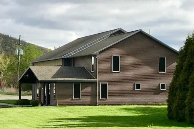
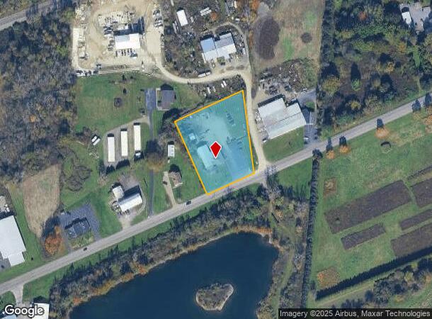
Property Record
3312 State Route 352, Corning, NY 14830
NEARBY LISTINGS FOR SALE OR LEASE
-
-
View all Corning listings for sale on LoopNet.com
Property Detail
3312 State Route 352
Elmira, NY
INTERSTATE BATTERIES
072400-076-001-0001-007-024-0000
Chemung
Manufacturinglight
New York
2025
7.024
2024
2 AC
010302
Other Market Areas
4,580 SF
DEMOGRAPHICS near 3312 State Route 352
1 Mile
3 Mile
5 Mile
2024 Total Population
858
4,887
13,321
2029 Population
831
4,736
12,942
Pop Growth 2024-2029
(3.15%)
(3.09%)
(2.85%)
Average Age
44
44
43
2024 Total Households
356
2,002
5,636
HH Growth 2024-2029
(3.37%)
(3.15%)
(2.95%)
Median Household Inc
$97,158
$100,457
$88,237
Avg Household Size
2.40
2.40
2.30
2024 Avg HH Vehicles
2.00
2.00
2.00
Median Home Value
$182,517
$185,650
$180,631
Median Year Built
1965
1965
1962
Nearby Places
Map Layers
Map Styles
 Street
 Aerial
- Restaurants
- Banks
- Shops
- Fitness
- Groceries
PUBLIC TRANSPORTATION
AIRPORT
Elmira/Corning Regional
DRIVE
WALK
Distance
Elmira/Corning Regional
10 min
4.9 mi
Ithaca Tompkins International
DRIVE
WALK
Distance
Ithaca Tompkins International
58 min
42.3 mi
SALE & LEASE HISTORY
LISTING DATE
SALE/LEASE

Jan 11, 2019
For Sale
Nearby Properties
Address
Land Use
TOTAL SIZE
Lot Size
Zoning
Address
Land Use
TOTAL SIZE
Lot Size
Zoning
226,000 SF
71.81 AC
CONF
Address
Land Use
TOTAL SIZE
Lot Size
Zoning
74,444 SF
626.30 AC
05 - COMME
Address
Land Use
TOTAL SIZE
Lot Size
Zoning
1,248 SF
2.97 AC
CONF
Address
Land Use
TOTAL SIZE
Lot Size
Zoning
9,739 SF
31.30 AC
04 - FARM
Address
Land Use
TOTAL SIZE
Lot Size
Zoning
Address
Land Use
TOTAL SIZE
Lot Size
Zoning
15,000 SF
17.46 AC
05 - COMME
Address
Land Use
TOTAL SIZE
Lot Size
Zoning
98,213 SF
17.07 AC
06 - INDUS
Address
Land Use
TOTAL SIZE
Lot Size
Zoning
265,710 SF
63.70 AC
06 - INDUS
Address
Land Use
TOTAL SIZE
Lot Size
Zoning
1.09 AC
CONF
Address
Land Use
TOTAL SIZE
Lot Size
Zoning
48,792 SF
22.15 AC
05 - COMME
Address
Land Use
TOTAL SIZE
Lot Size
Zoning
60,440 SF
14.80 AC
05 - COMME
Address
Land Use
TOTAL SIZE
Lot Size
Zoning
29,534 SF
4.40 AC
06 - INDUS
Address
Land Use
TOTAL SIZE
Lot Size
Zoning
63,000 SF
10.77 AC
06 - INDUS
Address
Land Use
TOTAL SIZE
Lot Size
Zoning
4,768 SF
10 AC
05 - COMME
Address
Land Use
TOTAL SIZE
Lot Size
Zoning
52,158 SF
16.80 AC
04 - FARM
Address
Land Use
TOTAL SIZE
Lot Size
Zoning
15,107 SF
283.85 AC
CONF
Address
Land Use
TOTAL SIZE
Lot Size
Zoning
118.20 AC
Address
Land Use
TOTAL SIZE
Lot Size
Zoning
71.96 AC
CONF
Address
Land Use
TOTAL SIZE
Lot Size
Zoning
34,688 SF
2.40 AC
02 - SINGL
Address
Land Use
TOTAL SIZE
Lot Size
Zoning
2,896 SF
7.77 AC
06 - INDUS
Address
Land Use
TOTAL SIZE
Lot Size
Zoning
26,662 SF
4 AC
05 - COMME
Address
Land Use
TOTAL SIZE
Lot Size
Zoning
4,158 SF
17.22 AC
02 - SINGL
Address
Land Use
TOTAL SIZE
Lot Size
Zoning
13,316 SF
10.17 AC
06 - INDUS
Address
Land Use
TOTAL SIZE
Lot Size
Zoning
9,100 SF
1.38 AC
05 - COMME
Address
Land Use
TOTAL SIZE
Lot Size
Zoning
129.10 AC
05 - COMME
Address
Land Use
TOTAL SIZE
Lot Size
Zoning
7,800 SF
5.80 AC
CONF
Address
Land Use
TOTAL SIZE
Lot Size
Zoning
15,408 SF
8.10 AC
CONF
Address
Land Use
TOTAL SIZE
Lot Size
Zoning
16,477 SF
8.24 AC
05 - COMME
Address
Land Use
TOTAL SIZE
Lot Size
Zoning
36.27 AC
06 - INDUS
Address
Land Use
TOTAL SIZE
Lot Size
Zoning
13,565 SF
14.20 AC
05 - COMME
The World's #1 Commercial Real Estate Marketplace
Connect with us
© 2025 CoStar Group
The information above has been obtained from sources believed reliable. While we do not doubt its accuracy we have not verified it and make no guarantee, warranty or representation about it. It is your responsibility to independently confirm its accuracy and completeness. Any projections, opinions, assumptions, or estimates used are for example only and do not represent the current or future performance of the property. The value of this transaction to you depends on tax and other factors which should be evaluated by your tax, financial, and legal advisors. You and your advisors should conduct a careful, independent investigation of the property to determine to your satisfaction the suitability of the property for your needs.