Property Record
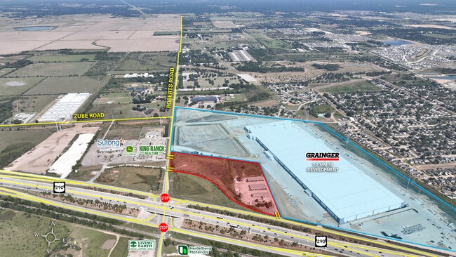
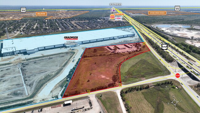
33100 Highway 290, Hockley, TX 77447

Property Detail
33100 Highway 290
0451490000003
TR 3 ABST 845 R WALTON
Outdoorrecreationbeachmountaindesert
HARRIS
B and X Area of moderate flood hazard, usually the area between the limits of the 100-year and 500-year floods.
Texas
2024
11.96 AC
2025
Northwest Outlier
556000
Houston
26,250 SF
Houston-Pasadena-The Woodlands, TX
NEARBY LISTINGS FOR SALE OR LEASE
DEMOGRAPHICS near 33100 Highway 290
1 mile
3 mile
5 mile
2025 Total Population
3,820
15,563
40,530
2030 Population
4,150
17,463
44,409
Pop Growth 2025-2030
+ 8.64%
+ 12.21%
+ 9.57%
Average Age
34
34
35
2025 Total Households
1,182
4,808
12,546
HH Growth 2025-2030
+ 8.88%
+ 12.56%
+ 9.77%
Median Household Inc
$100,584
$110,898
$121,482
Avg Household Size
3.20
3.20
3.20
2025 Avg HH Vehicles
2.00
2.00
2.00
Median Home Value
$243,092
$320,936
$360,021
Median Year Built
1999
2010
2010
Nearby Places
Map Layers
Map Styles
 Street
 Aerial
Transit
 Traffic
 Biking
Places
Listings with unknown addresses are not visible on the map
- Restaurants
- Banks
- Shops
- Fitness
- Groceries
PUBLIC TRANSPORTATION
AIRPORT
George Bush Intcntl/Houston
Drive
Walk
Distance
George Bush Intcntl/Houston
47 min
34.9 mi
Freight Ports
Port of Houston
Drive
Walk
Distance
Port of Houston
57 min
43.7 mi
SALE & LEASE HISTORY
LISTING DATE
SALE/LEASE

Oct 11, 2018
For Lease
Nov 17, 2025
For Sale
Feb 10, 2017
For Lease
Nearby Properties
Address
Land Use
TOTAL SIZE
Lot Size
Zoning
Address
Land Use
TOTAL SIZE
Lot Size
Zoning
268,960 SF
21.70 AC
Address
Land Use
TOTAL SIZE
Lot Size
Zoning
785.28 AC
Address
Land Use
TOTAL SIZE
Lot Size
Zoning
61,242 SF
30 AC
Address
Land Use
TOTAL SIZE
Lot Size
Zoning
108.28 AC
Address
Land Use
TOTAL SIZE
Lot Size
Zoning
568.93 AC
Address
Land Use
TOTAL SIZE
Lot Size
Zoning
34,298 SF
28.42 AC
Address
Land Use
TOTAL SIZE
Lot Size
Zoning
191,008 SF
20.47 AC
Address
Land Use
TOTAL SIZE
Lot Size
Zoning
156.25 AC
Address
Land Use
TOTAL SIZE
Lot Size
Zoning
245.22 AC
Address
Land Use
TOTAL SIZE
Lot Size
Zoning
383.95 AC
Address
Land Use
TOTAL SIZE
Lot Size
Zoning
860.08 AC
Address
Land Use
TOTAL SIZE
Lot Size
Zoning
42,400 SF
19.73 AC
Address
Land Use
TOTAL SIZE
Lot Size
Zoning
149.01 AC
Address
Land Use
TOTAL SIZE
Lot Size
Zoning
557.31 AC
Address
Land Use
TOTAL SIZE
Lot Size
Zoning
60,390 SF
13.71 AC
Address
Land Use
TOTAL SIZE
Lot Size
Zoning
68.28 AC
Address
Land Use
TOTAL SIZE
Lot Size
Zoning
228.82 AC
Address
Land Use
TOTAL SIZE
Lot Size
Zoning
22.72 AC
Address
Land Use
TOTAL SIZE
Lot Size
Zoning
54,630 SF
4 AC
Address
Land Use
TOTAL SIZE
Lot Size
Zoning
284.51 AC
Address
Land Use
TOTAL SIZE
Lot Size
Zoning
165.60 AC
Address
Land Use
TOTAL SIZE
Lot Size
Zoning
208.88 AC
Address
Land Use
TOTAL SIZE
Lot Size
Zoning
96.10 AC
Address
Land Use
TOTAL SIZE
Lot Size
Zoning
240.01 AC
Address
Land Use
TOTAL SIZE
Lot Size
Zoning
101.74 AC
Address
Land Use
TOTAL SIZE
Lot Size
Zoning
11,108 SF
4.02 AC
Address
Land Use
TOTAL SIZE
Lot Size
Zoning
98.34 AC
Address
Land Use
TOTAL SIZE
Lot Size
Zoning
9,600 SF
31.20 AC
Address
Land Use
TOTAL SIZE
Lot Size
Zoning
18,350 SF
4.12 AC
Address
Land Use
TOTAL SIZE
Lot Size
Zoning
35.15 AC
The World's #1 Commercial Real Estate Marketplace
Connect with us
© 2026 CoStar Group
The information above has been obtained from sources believed reliable. While we do not doubt its accuracy we have not verified it and make no guarantee, warranty or representation about it. It is your responsibility to independently confirm its accuracy and completeness. Any projections, opinions, assumptions, or estimates used are for example only and do not represent the current or future performance of the property. The value of this transaction to you depends on tax and other factors which should be evaluated by your tax, financial, and legal advisors. You and your advisors should conduct a careful, independent investigation of the property to determine to your satisfaction the suitability of the property for your needs.