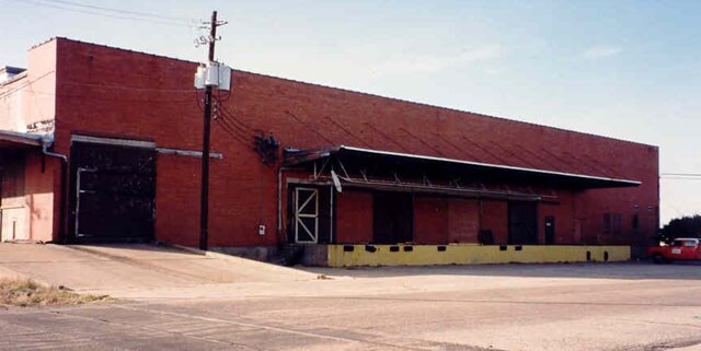
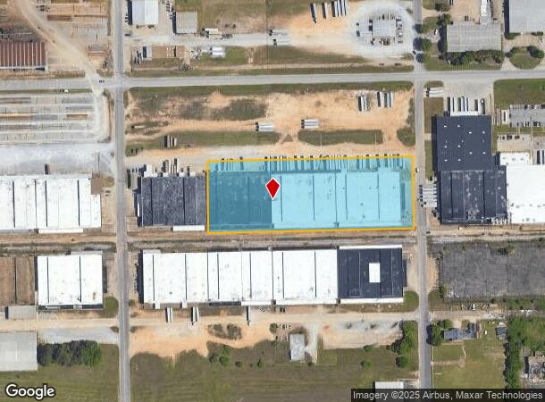
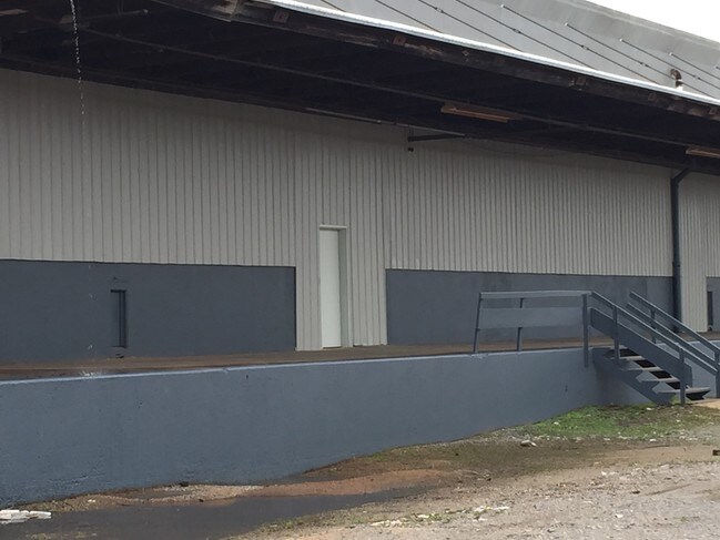
Property Record
3311 Brewbaker Ave, Montgomery, AL 36108
NEARBY LISTINGS FOR SALE OR LEASE
-
-
-
-
-
-
No Photo
-
View all Montgomery listings for lease on LoopNet.com
Property Detail
3311 Brewbaker Ave
11-05-22-2-001-021.000
Plat No 1 Of Montgomery Industrial Termi
Publicstorage
BEG NW INT BREWBAKER AVE & KERSHAW ST TH W 765 TH N 260 TH E 765 TH S 265 TO POB 1105222001021000
X
Montgomery
01101C0201J
Alabama
2025
5.26 AC
2025
South Montgomery
003000
Montgomery
141,036 SF
Montgomery, AL
DEMOGRAPHICS near 3311 Brewbaker Ave
1 Mile
3 Mile
5 Mile
2024 Total Population
1,761
26,389
63,240
2029 Population
1,795
27,060
63,637
Pop Growth 2024-2029
+ 1.93%
+ 2.54%
+ 0.63%
Average Age
38
40
39
2024 Total Households
710
10,857
25,088
HH Growth 2024-2029
+ 1.97%
+ 2.83%
+ 0.91%
Median Household Inc
$28,110
$25,656
$33,074
Avg Household Size
2.40
2.20
2.30
2024 Avg HH Vehicles
1.00
1.00
2.00
Median Home Value
$65,586
$69,971
$84,411
Median Year Built
1972
1965
1963
Nearby Places
Map Layers
Map Styles
 Street
 Aerial
- Restaurants
- Banks
- Shops
- Fitness
- Groceries
PUBLIC TRANSPORTATION
AIRPORT
Montgomery Regional (Dannelly Field)
DRIVE
WALK
Distance
Montgomery Regional (Dannelly Field)
11 min
6.7 mi
Freight Ports
Port of Mobile
DRIVE
WALK
Distance
Port of Mobile
183 min
166.8 mi
SALE & LEASE HISTORY
LISTING DATE
SALE/LEASE

Sep 25, 2016
For Lease
Nearby Properties
Address
Land Use
TOTAL SIZE
Lot Size
Zoning
Address
Land Use
TOTAL SIZE
Lot Size
Zoning
657,684 SF
59 AC
M-1
Address
Land Use
TOTAL SIZE
Lot Size
Zoning
107,355 SF
4.12 AC
T5
Address
Land Use
TOTAL SIZE
Lot Size
Zoning
391,901 SF
13 AC
M-3
Address
Land Use
TOTAL SIZE
Lot Size
Zoning
162 AC
INST
Address
Land Use
TOTAL SIZE
Lot Size
Zoning
129,122 SF
9.60 AC
M-3
Address
Land Use
TOTAL SIZE
Lot Size
Zoning
193,544 SF
20.33 AC
M-3
Address
Land Use
TOTAL SIZE
Lot Size
Zoning
1,693 SF
3.29 AC
B-1-A-Q
Address
Land Use
TOTAL SIZE
Lot Size
Zoning
176,106 SF
19.22 AC
M-3
Address
Land Use
TOTAL SIZE
Lot Size
Zoning
8,483 SF
18.66 AC
M-1
Address
Land Use
TOTAL SIZE
Lot Size
Zoning
46,760 SF
4.38 AC
R-65-D
Address
Land Use
TOTAL SIZE
Lot Size
Zoning
7,928 SF
2.39 AC
R-60-D
Address
Land Use
TOTAL SIZE
Lot Size
Zoning
88,994 SF
5.16 AC
INST
Address
Land Use
TOTAL SIZE
Lot Size
Zoning
146,238 SF
8.60 AC
M-1
Address
Land Use
TOTAL SIZE
Lot Size
Zoning
18,035 SF
14 AC
INST
Address
Land Use
TOTAL SIZE
Lot Size
Zoning
44,263 SF
3.42 AC
B-4
Address
Land Use
TOTAL SIZE
Lot Size
Zoning
28,461 SF
5.20 AC
M-3
Address
Land Use
TOTAL SIZE
Lot Size
Zoning
37,048 SF
10.90 AC
M-3
Address
Land Use
TOTAL SIZE
Lot Size
Zoning
142,617 SF
17 AC
B-2
Address
Land Use
TOTAL SIZE
Lot Size
Zoning
105 AC
INST
Address
Land Use
TOTAL SIZE
Lot Size
Zoning
26,633 SF
21.50 AC
Address
Land Use
TOTAL SIZE
Lot Size
Zoning
40,917 SF
5.55 AC
M-1
Address
Land Use
TOTAL SIZE
Lot Size
Zoning
75,544 SF
4 AC
INST
Address
Land Use
TOTAL SIZE
Lot Size
Zoning
12,024 SF
4.15 AC
M-1
Address
Land Use
TOTAL SIZE
Lot Size
Zoning
87,906 SF
63 AC
M-3
Address
Land Use
TOTAL SIZE
Lot Size
Zoning
4,801 SF
22.72 AC
M-3
Address
Land Use
TOTAL SIZE
Lot Size
Zoning
84 AC
INST
Address
Land Use
TOTAL SIZE
Lot Size
Zoning
48,030 SF
2.07 AC
T4-R
Address
Land Use
TOTAL SIZE
Lot Size
Zoning
161,902 SF
7.20 AC
M-3
Address
Land Use
TOTAL SIZE
Lot Size
Zoning
30,658 SF
0.50 AC
R-60-D
Address
Land Use
TOTAL SIZE
Lot Size
Zoning
51,207 SF
12.90 AC
M-3
The World's #1 Commercial Real Estate Marketplace
Connect with us
© 2025 CoStar Group
The information above has been obtained from sources believed reliable. While we do not doubt its accuracy we have not verified it and make no guarantee, warranty or representation about it. It is your responsibility to independently confirm its accuracy and completeness. Any projections, opinions, assumptions, or estimates used are for example only and do not represent the current or future performance of the property. The value of this transaction to you depends on tax and other factors which should be evaluated by your tax, financial, and legal advisors. You and your advisors should conduct a careful, independent investigation of the property to determine to your satisfaction the suitability of the property for your needs.