Property Record
3311 N Interstate 35, Austin, TX 78722
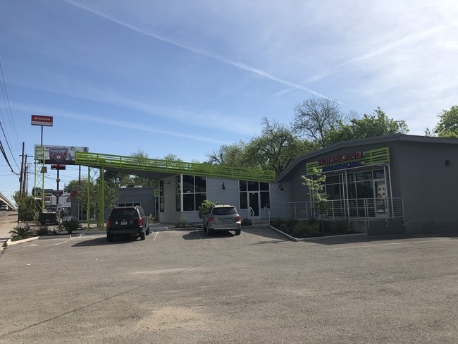


Property Detail
3311 N Interstate 35
Austin-Round Rock-San Marcos, TX
LOT 4-7 BLK 1 OLT 29 DIV C UNIVERSITY PARK SUBD
209083
Travis
Stripcommercialcenter
Texas
B and X Area of moderate flood hazard, usually the area between the limits of the 100-year and 500-year floods.
4-7
2023
0.51 AC
2023
East
000401
Austin
5,648 SF
NEARBY LISTINGS FOR SALE OR LEASE
DEMOGRAPHICS near 3311 N Interstate 35
1 mile
3 mile
5 mile
2024 Total Population
21,271
190,475
397,992
2029 Population
22,481
201,187
419,671
Pop Growth 2024-2029
+ 5.69%
+ 5.62%
+ 5.45%
Average Age
34
36
36
2024 Total Households
10,148
88,347
180,773
HH Growth 2024-2029
+ 6.51%
+ 6.54%
+ 6.28%
Median Household Inc
$78,077
$92,825
$87,648
Avg Household Size
1.90
1.90
2.00
2024 Avg HH Vehicles
1.00
1.00
2.00
Median Home Value
$751,279
$776,107
$775,402
Median Year Built
1981
2000
1992
Nearby Places
Map Layers
Map Styles
 Street
 Aerial
Transit
 Traffic
 Biking
Places
Listings with unknown addresses are not visible on the map
- Restaurants
- Banks
- Shops
- Fitness
- Groceries
PUBLIC TRANSPORTATION
COMMUTER RAIL
Drive
Walk
Distance
9 min
4.1 mi
AIRPORT
Austin-Bergstrom International
Drive
Walk
Distance
Austin-Bergstrom International
23 min
12.0 mi
SALE & LEASE HISTORY
LISTING DATE
SALE/LEASE

Sep 25, 2016
For Lease
Jun 15, 2020
For Sale
Jul 22, 2021
For Lease
Jan 17, 2020
For Lease
Apr 09, 2019
For Lease
Apr 09, 2019
For Sale
Apr 03, 2018
For Sale
Apr 01, 2020
For Lease
Nearby Properties
Address
Land Use
TOTAL SIZE
Lot Size
Zoning
Address
Land Use
TOTAL SIZE
Lot Size
Zoning
1,008,789 SF
17.50 AC
Address
Land Use
TOTAL SIZE
Lot Size
Zoning
20,550 SF
14.15 AC
Address
Land Use
TOTAL SIZE
Lot Size
Zoning
262 SF
65.06 AC
Address
Land Use
TOTAL SIZE
Lot Size
Zoning
28.39 AC
Address
Land Use
TOTAL SIZE
Lot Size
Zoning
Address
Land Use
TOTAL SIZE
Lot Size
Zoning
28.62 AC
Address
Land Use
TOTAL SIZE
Lot Size
Zoning
1,156,135 SF
1.74 AC
Address
Land Use
TOTAL SIZE
Lot Size
Zoning
1,003,475 SF
1.84 AC
Address
Land Use
TOTAL SIZE
Lot Size
Zoning
27.17 AC
Address
Land Use
TOTAL SIZE
Lot Size
Zoning
136,900 SF
19.32 AC
Address
Land Use
TOTAL SIZE
Lot Size
Zoning
786,600 SF
1.27 AC
Address
Land Use
TOTAL SIZE
Lot Size
Zoning
24.50 AC
Address
Land Use
TOTAL SIZE
Lot Size
Zoning
9,034 SF
28.69 AC
Address
Land Use
TOTAL SIZE
Lot Size
Zoning
30.96 AC
Address
Land Use
TOTAL SIZE
Lot Size
Zoning
709,300 SF
0.94 AC
Address
Land Use
TOTAL SIZE
Lot Size
Zoning
18.52 AC
Address
Land Use
TOTAL SIZE
Lot Size
Zoning
74.69 AC
Address
Land Use
TOTAL SIZE
Lot Size
Zoning
47.20 AC
Address
Land Use
TOTAL SIZE
Lot Size
Zoning
1,400,000 SF
3.07 AC
Address
Land Use
TOTAL SIZE
Lot Size
Zoning
789,220 SF
14.34 AC
Address
Land Use
TOTAL SIZE
Lot Size
Zoning
548,399 SF
23.82 AC
Address
Land Use
TOTAL SIZE
Lot Size
Zoning
35,041 SF
28.65 AC
Address
Land Use
TOTAL SIZE
Lot Size
Zoning
623,000 SF
11.78 AC
Address
Land Use
TOTAL SIZE
Lot Size
Zoning
21 AC
Address
Land Use
TOTAL SIZE
Lot Size
Zoning
614,532 SF
66.07 AC
Address
Land Use
TOTAL SIZE
Lot Size
Zoning
513,567 SF
1.78 AC
Address
Land Use
TOTAL SIZE
Lot Size
Zoning
500,511 SF
0.82 AC
Address
Land Use
TOTAL SIZE
Lot Size
Zoning
609,613 SF
1.31 AC
Address
Land Use
TOTAL SIZE
Lot Size
Zoning
24.06 AC
The World's #1 Commercial Real Estate Marketplace
Connect with us
© 2026 CoStar Group
The information above has been obtained from sources believed reliable. While we do not doubt its accuracy we have not verified it and make no guarantee, warranty or representation about it. It is your responsibility to independently confirm its accuracy and completeness. Any projections, opinions, assumptions, or estimates used are for example only and do not represent the current or future performance of the property. The value of this transaction to you depends on tax and other factors which should be evaluated by your tax, financial, and legal advisors. You and your advisors should conduct a careful, independent investigation of the property to determine to your satisfaction the suitability of the property for your needs.