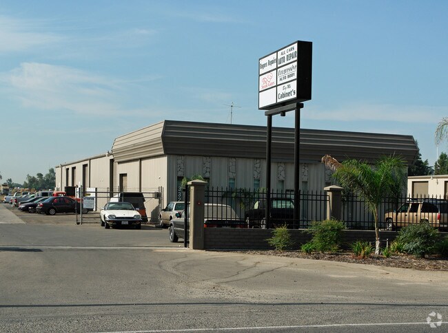
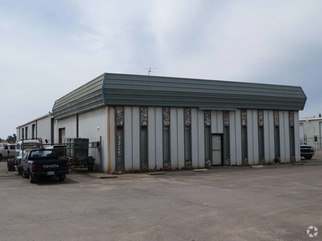
Property Record
3311 W Belmont Ave, Fresno, CA 93722


NEARBY LISTINGS FOR SALE OR LEASE
Property Detail
3311 W Belmont Ave
Fresno, CA
West Fresno #2
326-060-02
4.62 AC LOT 1 WEST FRESNO TRACT NO 2
Warehouse
Fresno
X
California
06019C2105H
1
2025
4.62 AC
2025
Southwest Fresno
003807
Fresno
26,600 SF
DEMOGRAPHICS near 3311 W Belmont Ave
1 Mile
3 Mile
5 Mile
2024 Total Population
3,680
84,019
235,891
2029 Population
3,731
85,392
240,599
Pop Growth 2024-2029
+ 1.39%
+ 1.63%
+ 2.00%
Average Age
35
35
35
2024 Total Households
1,102
26,210
74,439
HH Growth 2024-2029
+ 1.36%
+ 1.61%
+ 2.02%
Median Household Inc
$31,666
$50,751
$49,657
Avg Household Size
3.20
3.10
3.00
2024 Avg HH Vehicles
2.00
2.00
2.00
Median Home Value
$158,333
$257,183
$271,124
Median Year Built
1971
1968
1969
Nearby Places
Map Layers
Map Styles
 Street
 Aerial
- Restaurants
- Banks
- Shops
- Fitness
- Groceries
PUBLIC TRANSPORTATION
COMMUTER RAIL
DRIVE
WALK
Distance
9 min
4.7 mi
AIRPORT
Fresno Yosemite International
DRIVE
WALK
Distance
Fresno Yosemite International
15 min
10.4 mi
SALE & LEASE HISTORY
LISTING DATE
SALE/LEASE

Nov 22, 2017
For Lease
Nearby Properties
Address
Land Use
TOTAL SIZE
Lot Size
Zoning
Address
Land Use
TOTAL SIZE
Lot Size
Zoning
141,959 SF
35.39 AC
SPLIT
Address
Land Use
TOTAL SIZE
Lot Size
Zoning
61,575 SF
3.50 AC
SPLIT
Address
Land Use
TOTAL SIZE
Lot Size
Zoning
159,822 SF
9.67 AC
R2
Address
Land Use
TOTAL SIZE
Lot Size
Zoning
71,384 SF
6.34 AC
IL
Address
Land Use
TOTAL SIZE
Lot Size
Zoning
106,740 SF
63.59 AC
AE20
Address
Land Use
TOTAL SIZE
Lot Size
Zoning
32,156 SF
2.60 AC
C6
Address
Land Use
TOTAL SIZE
Lot Size
Zoning
103,088 SF
5.41 AC
R3
Address
Land Use
TOTAL SIZE
Lot Size
Zoning
113,419 SF
1.26 AC
C4
Address
Land Use
TOTAL SIZE
Lot Size
Zoning
84,050 SF
6.84 AC
R3
Address
Land Use
TOTAL SIZE
Lot Size
Zoning
111,104 SF
7.96 AC
R2A
Address
Land Use
TOTAL SIZE
Lot Size
Zoning
88,345 SF
5.18 AC
R3
Address
Land Use
TOTAL SIZE
Lot Size
Zoning
95,874 SF
5.46 AC
R3
Address
Land Use
TOTAL SIZE
Lot Size
Zoning
98,542 SF
6.94 AC
R4
Address
Land Use
TOTAL SIZE
Lot Size
Zoning
84,309 SF
3.97 AC
R3
Address
Land Use
TOTAL SIZE
Lot Size
Zoning
53,928 SF
1.19 AC
C4
Address
Land Use
TOTAL SIZE
Lot Size
Zoning
74,212 SF
4.38 AC
R3
Address
Land Use
TOTAL SIZE
Lot Size
Zoning
86,559 SF
5.40 AC
R3
Address
Land Use
TOTAL SIZE
Lot Size
Zoning
53,495 SF
4.96 AC
R2A
Address
Land Use
TOTAL SIZE
Lot Size
Zoning
127,758 SF
7.82 AC
R3
Address
Land Use
TOTAL SIZE
Lot Size
Zoning
26,962 SF
2 AC
M1
Address
Land Use
TOTAL SIZE
Lot Size
Zoning
68,697 SF
5.17 AC
R3
Address
Land Use
TOTAL SIZE
Lot Size
Zoning
45,376 SF
4.47 AC
CM
Address
Land Use
TOTAL SIZE
Lot Size
Zoning
23,616 SF
5.22 AC
SPLIT
Address
Land Use
TOTAL SIZE
Lot Size
Zoning
115,347 SF
2.17 AC
C4
Address
Land Use
TOTAL SIZE
Lot Size
Zoning
63,250 SF
3.67 AC
C6
Address
Land Use
TOTAL SIZE
Lot Size
Zoning
88,327 SF
7.61 AC
R2A
Address
Land Use
TOTAL SIZE
Lot Size
Zoning
44,423 SF
2.13 AC
C6
Address
Land Use
TOTAL SIZE
Lot Size
Zoning
50,318 SF
5.01 AC
C1
Address
Land Use
TOTAL SIZE
Lot Size
Zoning
123,727 SF
15.17 AC
CG
Address
Land Use
TOTAL SIZE
Lot Size
Zoning
60,438 SF
11.46 AC
M1
The World's #1 Commercial Real Estate Marketplace
Connect with us
© 2026 CoStar Group
The information above has been obtained from sources believed reliable. While we do not doubt its accuracy we have not verified it and make no guarantee, warranty or representation about it. It is your responsibility to independently confirm its accuracy and completeness. Any projections, opinions, assumptions, or estimates used are for example only and do not represent the current or future performance of the property. The value of this transaction to you depends on tax and other factors which should be evaluated by your tax, financial, and legal advisors. You and your advisors should conduct a careful, independent investigation of the property to determine to your satisfaction the suitability of the property for your needs.