Property Record
3315 N N N Loop Loop W Loop W Loop W, Midland, TX 79707
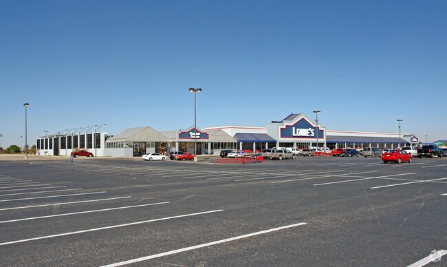
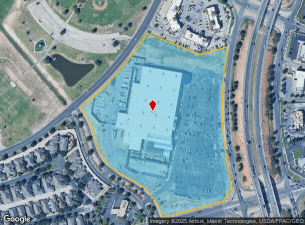
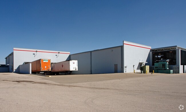
Property Detail
3315 N N N Loop Loop W Loop W Loop W
Other Market Areas
Grandridge Park
Midland, TX
ACRES: 18.520 BLK: 002 LOT: 002 ADDN: GRANDRIDGE PARK SEC 1
R000021-421
Midland
Officebuilding
Texas
2025
2
2025
18.52 AC
010120
Midland & Odessa
408,321 SF
NEARBY LISTINGS FOR SALE OR LEASE
DEMOGRAPHICS near 3315 N N N Loop Loop W Loop W Loop W
1 mile
3 mile
5 mile
2024 Total Population
13,451
64,944
103,627
2029 Population
13,950
66,979
106,760
Pop Growth 2024-2029
+ 3.71%
+ 3.13%
+ 3.02%
Average Age
36
35
36
2024 Total Households
5,127
24,450
38,855
HH Growth 2024-2029
+ 3.94%
+ 3.45%
+ 3.37%
Median Household Inc
$99,544
$96,474
$91,849
Avg Household Size
2.60
2.60
2.60
2024 Avg HH Vehicles
2.00
2.00
2.00
Median Home Value
$353,981
$296,618
$291,393
Median Year Built
1993
1987
1984
Nearby Places
Map Layers
Map Styles
 Street
 Aerial
Transit
 Traffic
 Biking
Places
Listings with unknown addresses are not visible on the map
- Restaurants
- Banks
- Shops
- Fitness
- Groceries
PUBLIC TRANSPORTATION
AIRPORT
Midland International Air And Space Port
Drive
Walk
Distance
Midland International Air And Space Port
16 min
9.8 mi
Nearby Properties
Address
Land Use
TOTAL SIZE
Lot Size
Zoning
Address
Land Use
TOTAL SIZE
Lot Size
Zoning
322,000 SF
24.88 AC
Address
Land Use
TOTAL SIZE
Lot Size
Zoning
25,575 SF
8.90 AC
Address
Land Use
TOTAL SIZE
Lot Size
Zoning
56,157 SF
18.19 AC
PDOC
Address
Land Use
TOTAL SIZE
Lot Size
Zoning
6,266 SF
17.84 AC
Address
Land Use
TOTAL SIZE
Lot Size
Zoning
2,339 SF
17.14 AC
Address
Land Use
TOTAL SIZE
Lot Size
Zoning
7,839 SF
12.92 AC
Address
Land Use
TOTAL SIZE
Lot Size
Zoning
28,571 SF
17.07 AC
Address
Land Use
TOTAL SIZE
Lot Size
Zoning
2,453 SF
13.68 AC
Address
Land Use
TOTAL SIZE
Lot Size
Zoning
1,173 SF
14.05 AC
PDHD
Address
Land Use
TOTAL SIZE
Lot Size
Zoning
24,000 SF
11.87 AC
Address
Land Use
TOTAL SIZE
Lot Size
Zoning
2,196 SF
15.11 AC
PDHD
Address
Land Use
TOTAL SIZE
Lot Size
Zoning
7,793 SF
15.51 AC
Address
Land Use
TOTAL SIZE
Lot Size
Zoning
262,640 SF
13.71 AC
MF1
Address
Land Use
TOTAL SIZE
Lot Size
Zoning
28,750 SF
10.11 AC
Address
Land Use
TOTAL SIZE
Lot Size
Zoning
676 SF
11.40 AC
Address
Land Use
TOTAL SIZE
Lot Size
Zoning
7,200 SF
17.74 AC
MF1
Address
Land Use
TOTAL SIZE
Lot Size
Zoning
15,000 SF
39.46 AC
PDHD
Address
Land Use
TOTAL SIZE
Lot Size
Zoning
600 SF
12.45 AC
MF1
Address
Land Use
TOTAL SIZE
Lot Size
Zoning
44,784 SF
11.97 AC
MF1
Address
Land Use
TOTAL SIZE
Lot Size
Zoning
2,440 SF
22.40 AC
Address
Land Use
TOTAL SIZE
Lot Size
Zoning
12,960 SF
15.93 AC
MF1
Address
Land Use
TOTAL SIZE
Lot Size
Zoning
1,725 SF
11.98 AC
MF1
Address
Land Use
TOTAL SIZE
Lot Size
Zoning
109,881 SF
10.38 AC
MF1
Address
Land Use
TOTAL SIZE
Lot Size
Zoning
5,884 SF
22.97 AC
PDSC
Address
Land Use
TOTAL SIZE
Lot Size
Zoning
7,200 SF
10.68 AC
MF1
Address
Land Use
TOTAL SIZE
Lot Size
Zoning
209,680 SF
6.16 AC
Address
Land Use
TOTAL SIZE
Lot Size
Zoning
1,369 SF
8.69 AC
MF1
Address
Land Use
TOTAL SIZE
Lot Size
Zoning
1,678 SF
9.11 AC
MF1
Address
Land Use
TOTAL SIZE
Lot Size
Zoning
5,600 SF
10.18 AC
PDMX
Address
Land Use
TOTAL SIZE
Lot Size
Zoning
1,618 SF
4.18 AC
The World's #1 Commercial Real Estate Marketplace
Connect with us
© 2026 CoStar Group
The information above has been obtained from sources believed reliable. While we do not doubt its accuracy we have not verified it and make no guarantee, warranty or representation about it. It is your responsibility to independently confirm its accuracy and completeness. Any projections, opinions, assumptions, or estimates used are for example only and do not represent the current or future performance of the property. The value of this transaction to you depends on tax and other factors which should be evaluated by your tax, financial, and legal advisors. You and your advisors should conduct a careful, independent investigation of the property to determine to your satisfaction the suitability of the property for your needs.