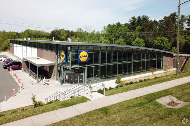
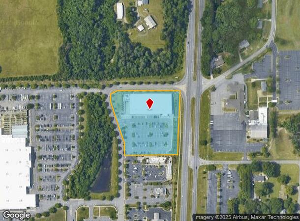
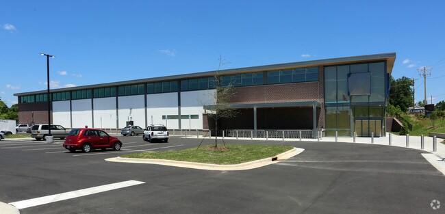
Property Record
3315 Sides Branch Rd, Winston Salem, NC 27127
NEARBY LISTINGS FOR SALE OR LEASE
Property Detail
3315 Sides Branch Rd
6823-72-0858
LO:101 BL:6652 PL:77-137
Storebuilding
Forsyth
X
North Carolina
3710682300J
101
0
3.72 AC
2025
South Forsyth County
003702
Greensboro/Winston-Salem
35,395 SF
Winston-Salem, NC
DEMOGRAPHICS near 3315 Sides Branch Rd
1 Mile
3 Mile
5 Mile
2024 Total Population
8,151
48,387
121,413
2029 Population
8,529
50,357
126,726
Pop Growth 2024-2029
+ 4.64%
+ 4.07%
+ 4.38%
Average Age
38
38
38
2024 Total Households
3,450
20,149
51,135
HH Growth 2024-2029
+ 4.64%
+ 4.05%
+ 4.46%
Median Household Inc
$65,135
$51,995
$52,937
Avg Household Size
2.30
2.30
2.20
2024 Avg HH Vehicles
2.00
2.00
2.00
Median Home Value
$159,009
$158,170
$180,529
Median Year Built
2000
1989
1979
Nearby Places
Map Layers
Map Styles
 Street
 Aerial
- Restaurants
- Banks
- Shops
- Fitness
- Groceries
PUBLIC TRANSPORTATION
AIRPORT
Piedmont Triad International
DRIVE
WALK
Distance
Piedmont Triad International
31 min
26.6 mi
Nearby Properties
Address
Land Use
TOTAL SIZE
Lot Size
Zoning
Address
Land Use
TOTAL SIZE
Lot Size
Zoning
123,109 SF
65.07 AC
C,HB,LO-S
Address
Land Use
TOTAL SIZE
Lot Size
Zoning
160,152 SF
26 AC
RM12-S,RM1
Address
Land Use
TOTAL SIZE
Lot Size
Zoning
30,360 SF
17.09 AC
CPO-S
Address
Land Use
TOTAL SIZE
Lot Size
Zoning
162,844 SF
57.77 AC
IP
Address
Land Use
TOTAL SIZE
Lot Size
Zoning
198,730 SF
37.41 AC
RS9
Address
Land Use
TOTAL SIZE
Lot Size
Zoning
211,658 SF
27.33 AC
MRB-S
Address
Land Use
TOTAL SIZE
Lot Size
Zoning
79,734 SF
22.54 AC
RM12-S
Address
Land Use
TOTAL SIZE
Lot Size
Zoning
276,164 SF
27.55 AC
HB
Address
Land Use
TOTAL SIZE
Lot Size
Zoning
59,612 SF
10.91 AC
MU-S
Address
Land Use
TOTAL SIZE
Lot Size
Zoning
186,776 SF
25.80 AC
IP
Address
Land Use
TOTAL SIZE
Lot Size
Zoning
176,680 SF
10.54 AC
MU-S
Address
Land Use
TOTAL SIZE
Lot Size
Zoning
57,837 SF
9.45 AC
RM18-S
Address
Land Use
TOTAL SIZE
Lot Size
Zoning
102,588 SF
13.98 AC
RM18
Address
Land Use
TOTAL SIZE
Lot Size
Zoning
46,212 SF
20.79 AC
RM8-S
Address
Land Use
TOTAL SIZE
Lot Size
Zoning
167,500 SF
14.96 AC
GI
Address
Land Use
TOTAL SIZE
Lot Size
Zoning
48,620 SF
15.51 AC
RM12-S
Address
Land Use
TOTAL SIZE
Lot Size
Zoning
992,551 SF
72.46 AC
GI
Address
Land Use
TOTAL SIZE
Lot Size
Zoning
139,248 SF
27.24 AC
MRB-S
Address
Land Use
TOTAL SIZE
Lot Size
Zoning
165,829 SF
17.75 AC
RM12-S
Address
Land Use
TOTAL SIZE
Lot Size
Zoning
188,088 SF
26.83 AC
RM18
Address
Land Use
TOTAL SIZE
Lot Size
Zoning
707,739 SF
60.36 AC
GI
Address
Land Use
TOTAL SIZE
Lot Size
Zoning
70,284 SF
6.57 AC
CPO
Address
Land Use
TOTAL SIZE
Lot Size
Zoning
77,143 SF
12.09 AC
NSB-S
Address
Land Use
TOTAL SIZE
Lot Size
Zoning
469,797 SF
73.87 AC
GI
Address
Land Use
TOTAL SIZE
Lot Size
Zoning
68,010 SF
15.32 AC
IP,RS9
Address
Land Use
TOTAL SIZE
Lot Size
Zoning
72,420 SF
9.82 AC
IP-S
Address
Land Use
TOTAL SIZE
Lot Size
Zoning
57,639 SF
5.96 AC
CPO,RS9
Address
Land Use
TOTAL SIZE
Lot Size
Zoning
20,266 SF
7.11 AC
CPO
Address
Land Use
TOTAL SIZE
Lot Size
Zoning
96,089 SF
14.91 AC
HB-S
Address
Land Use
TOTAL SIZE
Lot Size
Zoning
116,139 SF
16.03 AC
RM18,RM18-
The World's #1 Commercial Real Estate Marketplace
Connect with us
© 2025 CoStar Group
The information above has been obtained from sources believed reliable. While we do not doubt its accuracy we have not verified it and make no guarantee, warranty or representation about it. It is your responsibility to independently confirm its accuracy and completeness. Any projections, opinions, assumptions, or estimates used are for example only and do not represent the current or future performance of the property. The value of this transaction to you depends on tax and other factors which should be evaluated by your tax, financial, and legal advisors. You and your advisors should conduct a careful, independent investigation of the property to determine to your satisfaction the suitability of the property for your needs.