Property Record
3315 Springbank Ln, Charlotte, NC 28226


Current Lease Availabilities
NEARBY LISTINGS FOR SALE OR LEASE
Property Detail
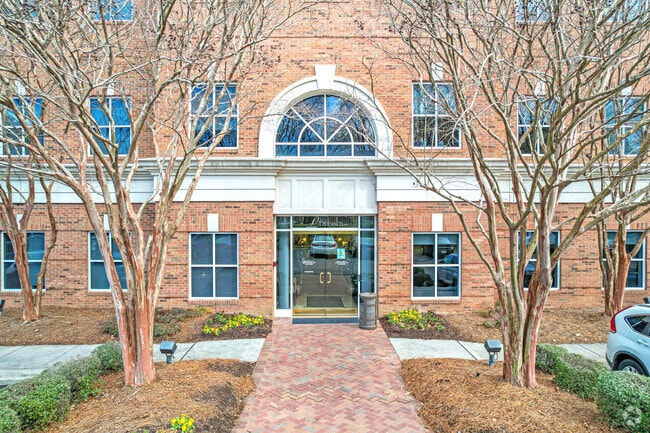
3315 Springbank Ln
Charlotte-Concord-Gastonia, NC-SC
Colony/Arboretum
211-271-25
L1 M33-147
Officebuilding
Mecklenburg
X
North Carolina
3710446900K
1
0
2.12 AC
2025
South Charlotte
003018
Charlotte
25,458 SF
DEMOGRAPHICS near 3315 Springbank Ln
1 Mile
3 Mile
5 Mile
2024 Total Population
8,378
68,702
205,408
2029 Population
8,732
71,835
216,688
Pop Growth 2024-2029
+ 4.23%
+ 4.56%
+ 5.49%
Average Age
39
41
41
2024 Total Households
3,368
26,116
83,828
HH Growth 2024-2029
+ 4.28%
+ 4.66%
+ 5.53%
Median Household Inc
$105,652
$127,996
$106,206
Avg Household Size
2.50
2.60
2.40
2024 Avg HH Vehicles
2.00
2.00
2.00
Median Home Value
$502,035
$493,461
$460,495
Median Year Built
1991
1989
1990
Nearby Places
Map Layers
Map Styles
 Street
 Aerial
- Restaurants
- Banks
- Shops
- Fitness
- Groceries
PUBLIC TRANSPORTATION
AIRPORT
Charlotte/Douglas International
DRIVE
WALK
Distance
Charlotte/Douglas International
30 min
16.5 mi
Concord-Padgett Regional
DRIVE
WALK
Distance
Concord-Padgett Regional
41 min
25.2 mi
Nearby Properties
Address
Land Use
TOTAL SIZE
Lot Size
Zoning
Address
Land Use
TOTAL SIZE
Lot Size
Zoning
442,934 SF
40.80 AC
R12MFCD
Address
Land Use
TOTAL SIZE
Lot Size
Zoning
191,929 SF
26.85 AC
B1SCD
Address
Land Use
TOTAL SIZE
Lot Size
Zoning
217,826 SF
82.89 AC
R3
Address
Land Use
TOTAL SIZE
Lot Size
Zoning
750,813 SF
56.11 AC
C
Address
Land Use
TOTAL SIZE
Lot Size
Zoning
304,043 SF
19.40 AC
R17MFCD
Address
Land Use
TOTAL SIZE
Lot Size
Zoning
312,194 SF
24.88 AC
R12MFCD
Address
Land Use
TOTAL SIZE
Lot Size
Zoning
268,545 SF
26.83 AC
R15MFCD
Address
Land Use
TOTAL SIZE
Lot Size
Zoning
288,495 SF
22.35 AC
R9PUD
Address
Land Use
TOTAL SIZE
Lot Size
Zoning
287,611 SF
12.73 AC
R3
Address
Land Use
TOTAL SIZE
Lot Size
Zoning
288,504 SF
30.19 AC
RI
Address
Land Use
TOTAL SIZE
Lot Size
Zoning
257,686 SF
26.78 AC
R8MFCD
Address
Land Use
TOTAL SIZE
Lot Size
Zoning
366,288 SF
45.44 AC
INSTCD
Address
Land Use
TOTAL SIZE
Lot Size
Zoning
185,878 SF
18.24 AC
CC
Address
Land Use
TOTAL SIZE
Lot Size
Zoning
193,391 SF
24.77 AC
R12MF
Address
Land Use
TOTAL SIZE
Lot Size
Zoning
232,878 SF
33.77 AC
MX2INNOV
Address
Land Use
TOTAL SIZE
Lot Size
Zoning
185,302 SF
47.89 AC
R3
Address
Land Use
TOTAL SIZE
Lot Size
Zoning
159,801 SF
17.02 AC
CC
Address
Land Use
TOTAL SIZE
Lot Size
Zoning
179,293 SF
17.48 AC
R15MFCD
Address
Land Use
TOTAL SIZE
Lot Size
Zoning
215,246 SF
14.49 AC
R3
Address
Land Use
TOTAL SIZE
Lot Size
Zoning
264,132 SF
58.71 AC
R3
Address
Land Use
TOTAL SIZE
Lot Size
Zoning
214,445 SF
15.80 AC
R15MFCD
Address
Land Use
TOTAL SIZE
Lot Size
Zoning
147,460 SF
40.12 AC
R3
Address
Land Use
TOTAL SIZE
Lot Size
Zoning
21.45 AC
Address
Land Use
TOTAL SIZE
Lot Size
Zoning
182,894 SF
14.51 AC
R15MFCD
Address
Land Use
TOTAL SIZE
Lot Size
Zoning
109,074 SF
9.13 AC
CC
Address
Land Use
TOTAL SIZE
Lot Size
Zoning
134,276 SF
12.51 AC
R15MFCD
Address
Land Use
TOTAL SIZE
Lot Size
Zoning
96,733 SF
10.01 AC
NS
Address
Land Use
TOTAL SIZE
Lot Size
Zoning
132,166 SF
33.09 AC
INST(CD)
Address
Land Use
TOTAL SIZE
Lot Size
Zoning
20.70 AC
Address
Land Use
TOTAL SIZE
Lot Size
Zoning
164,516 SF
30.57 AC
R-3
The World's #1 Commercial Real Estate Marketplace
Connect with us
© 2026 CoStar Group
The information above has been obtained from sources believed reliable. While we do not doubt its accuracy we have not verified it and make no guarantee, warranty or representation about it. It is your responsibility to independently confirm its accuracy and completeness. Any projections, opinions, assumptions, or estimates used are for example only and do not represent the current or future performance of the property. The value of this transaction to you depends on tax and other factors which should be evaluated by your tax, financial, and legal advisors. You and your advisors should conduct a careful, independent investigation of the property to determine to your satisfaction the suitability of the property for your needs.