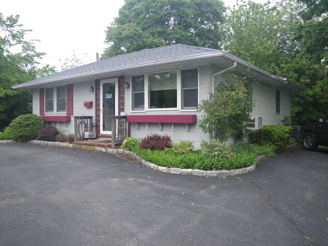
Property Record
33150 Main Rd, Cutchogue, NY 11935
NEARBY LISTINGS FOR SALE OR LEASE
-
-
View all Cutchogue listings for lease on LoopNet.com
Property Detail
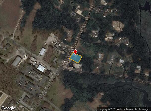
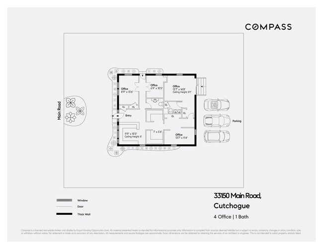
33150 Main Rd
Nassau County-Suffolk County, NY
BOOK 12444 PAGE 672 BILL 011177
1000-097-00-02-00-014-000
Suffolk
Commercialnec
New York
X
14
36103C0163H
0.25 AC
2024
Eastern Suffolk
2024
Long Island (New York)
170005
DEMOGRAPHICS near 33150 Main Rd
1 Mile
3 Mile
5 Mile
2024 Total Population
1,609
7,757
18,373
2029 Population
1,669
7,995
18,873
Pop Growth 2024-2029
+ 3.73%
+ 3.07%
+ 2.72%
Average Age
48
48
48
2024 Total Households
644
3,186
7,658
HH Growth 2024-2029
+ 3.73%
+ 3.01%
+ 2.65%
Median Household Inc
$114,660
$102,014
$100,930
Avg Household Size
2.40
2.40
2.30
2024 Avg HH Vehicles
2.00
2.00
2.00
Median Home Value
$716,981
$756,334
$739,870
Median Year Built
1978
1974
1974
Nearby Places
- Restaurants
- Banks
- Shops
- Fitness
- Groceries
PUBLIC TRANSPORTATION
COMMUTER RAIL
Southold Station (Greenport Branch - Long Island Rail Road)
DRIVE
WALK
Distance
Southold Station (Greenport Branch - Long Island Rail Road)
7 min
4.2 mi
Mattituck Station (Greenport Branch - Long Island Rail Road)
DRIVE
WALK
Distance
Mattituck Station (Greenport Branch - Long Island Rail Road)
7 min
4.8 mi
Freight Ports
Port of New Haven
DRIVE
WALK
Distance
Port of New Haven
166 min
71.3 mi
SALE & LEASE HISTORY
LISTING DATE
SALE/LEASE

Oct 28, 2021
For Sale
Oct 23, 2017
For Sale
Feb 16, 2023
For Lease
Nearby Properties
Address
Land Use
TOTAL SIZE
Lot Size
Zoning
Address
Land Use
TOTAL SIZE
Lot Size
Zoning
26.14 AC
R-80
Address
Land Use
TOTAL SIZE
Lot Size
Zoning
0.79 AC
VILLA
Address
Land Use
TOTAL SIZE
Lot Size
Zoning
Address
Land Use
TOTAL SIZE
Lot Size
Zoning
12.10 AC
R-80 B
Address
Land Use
TOTAL SIZE
Lot Size
Zoning
3.20 AC
R-80
Address
Land Use
TOTAL SIZE
Lot Size
Zoning
17.40 AC
RR
Address
Land Use
TOTAL SIZE
Lot Size
Zoning
4.91 AC
B
Address
Land Use
TOTAL SIZE
Lot Size
Zoning
0.47 AC
BUS1
Address
Land Use
TOTAL SIZE
Lot Size
Zoning
78.34 AC
AC
Address
Land Use
TOTAL SIZE
Lot Size
Zoning
Address
Land Use
TOTAL SIZE
Lot Size
Zoning
4.33 AC
R-80
Address
Land Use
TOTAL SIZE
Lot Size
Zoning
36.62 AC
R-80
Address
Land Use
TOTAL SIZE
Lot Size
Zoning
32.26 AC
R-80 R-40
Address
Land Use
TOTAL SIZE
Lot Size
Zoning
7.20 AC
AC
Address
Land Use
TOTAL SIZE
Lot Size
Zoning
72.30 AC
AC R-80
Address
Land Use
TOTAL SIZE
Lot Size
Zoning
59.94 AC
LI
Address
Land Use
TOTAL SIZE
Lot Size
Zoning
6 AC
R-40
Address
Land Use
TOTAL SIZE
Lot Size
Zoning
10.70 AC
R-40
Address
Land Use
TOTAL SIZE
Lot Size
Zoning
6.84 AC
AC
Address
Land Use
TOTAL SIZE
Lot Size
Zoning
Address
Land Use
TOTAL SIZE
Lot Size
Zoning
5.65 AC
LI
Address
Land Use
TOTAL SIZE
Lot Size
Zoning
99.76 AC
AC R-40
Address
Land Use
TOTAL SIZE
Lot Size
Zoning
6.52 AC
LI
Address
Land Use
TOTAL SIZE
Lot Size
Zoning
3.07 AC
LI
Address
Land Use
TOTAL SIZE
Lot Size
Zoning
21.24 AC
HD
Address
Land Use
TOTAL SIZE
Lot Size
Zoning
33.68 AC
AC
Address
Land Use
TOTAL SIZE
Lot Size
Zoning
2.61 AC
AC
Address
Land Use
TOTAL SIZE
Lot Size
Zoning
84.67 AC
AC R-80
Address
Land Use
TOTAL SIZE
Lot Size
Zoning
57.10 AC
R-80
Address
Land Use
TOTAL SIZE
Lot Size
Zoning
2.75 AC
LIO
The World's #1 Commercial Real Estate Marketplace
Connect with us
© 2025 CoStar Group
The information above has been obtained from sources believed reliable. While we do not doubt its accuracy we have not verified it and make no guarantee, warranty or representation about it. It is your responsibility to independently confirm its accuracy and completeness. Any projections, opinions, assumptions, or estimates used are for example only and do not represent the current or future performance of the property. The value of this transaction to you depends on tax and other factors which should be evaluated by your tax, financial, and legal advisors. You and your advisors should conduct a careful, independent investigation of the property to determine to your satisfaction the suitability of the property for your needs.