Property Record
3316 Benson Rd, Garner, NC 27529

Property Detail
3316 Benson Rd
1618.01-46-3894-000
BRITT LAND
Commercialnec
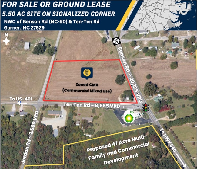
WAKE
CMX
North Carolina
B and X Area of moderate flood hazard, usually the area between the limits of the 100-year and 500-year floods.
6 AC
0
Southeast Wake County
2025
Raleigh/Durham
052814
Raleigh-Cary, NC
864 SF
NEARBY LISTINGS FOR SALE OR LEASE
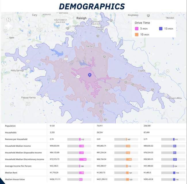
DEMOGRAPHICS near 3316 Benson Rd
1 mile
3 mile
5 mile
2025 Total Population
3,035
23,432
77,166
2030 Population
3,258
25,576
84,250
Pop Growth 2025-2030
+ 7.35%
+ 9.15%
+ 9.18%
Average Age
42
41
41
2025 Total Households
1,126
8,710
29,378
HH Growth 2025-2030
+ 7.73%
+ 9.46%
+ 9.52%
Median Household Inc
$93,768
$108,944
$97,159
Avg Household Size
2.70
2.60
2.60
2025 Avg HH Vehicles
2.00
2.00
2.00
Median Home Value
$385,361
$425,818
$398,166
Median Year Built
1998
2004
2002
Nearby Places
Map Layers
Map Styles
 Street
 Aerial
Layers
 Traffic
 Biking
Places
Listings with unknown addresses are not visible on the map
- Restaurants
- Banks
- Shops
- Fitness
- Groceries
PUBLIC TRANSPORTATION
AIRPORT
Raleigh-Durham International
Drive
Walk
Distance
Raleigh-Durham International
38 min
24.4 mi
Freight Ports
Port of Wilmington
Drive
Walk
Distance
Port of Wilmington
141 min
122.0 mi
SALE & LEASE HISTORY
LISTING DATE
SALE/LEASE

Oct 01, 2025
For Lease
Oct 01, 2025
For Sale
Nearby Properties
Address
Land Use
TOTAL SIZE
Lot Size
Zoning
Address
Land Use
TOTAL SIZE
Lot Size
Zoning
654,170 SF
16.14 AC
CMX-C
Address
Land Use
TOTAL SIZE
Lot Size
Zoning
323,031 SF
57.73 AC
R4
Address
Land Use
TOTAL SIZE
Lot Size
Zoning
15,231 SF
12.07 AC
COM
Address
Land Use
TOTAL SIZE
Lot Size
Zoning
112,243 SF
45.76 AC
RA
Address
Land Use
TOTAL SIZE
Lot Size
Zoning
5,640 SF
601.30 AC
RA
Address
Land Use
TOTAL SIZE
Lot Size
Zoning
68,099 SF
95.40 AC
R4
Address
Land Use
TOTAL SIZE
Lot Size
Zoning
70,069 SF
26.99 AC
MF-A
Address
Land Use
TOTAL SIZE
Lot Size
Zoning
65,096 SF
20.12 AC
NMX
Address
Land Use
TOTAL SIZE
Lot Size
Zoning
3,800 SF
664.21 AC
R-80W
Address
Land Use
TOTAL SIZE
Lot Size
Zoning
75,092 SF
3.56 AC
CU-HC
Address
Land Use
TOTAL SIZE
Lot Size
Zoning
42,088 SF
15.58 AC
R-30
Address
Land Use
TOTAL SIZE
Lot Size
Zoning
43,256 SF
15.08 AC
R-40W
Address
Land Use
TOTAL SIZE
Lot Size
Zoning
2,620 SF
138 AC
R8
Address
Land Use
TOTAL SIZE
Lot Size
Zoning
63.26 AC
IH
Address
Land Use
TOTAL SIZE
Lot Size
Zoning
24.34 AC
MF-A
Address
Land Use
TOTAL SIZE
Lot Size
Zoning
97.60 AC
R-40W
Address
Land Use
TOTAL SIZE
Lot Size
Zoning
90.70 AC
R2
Address
Land Use
TOTAL SIZE
Lot Size
Zoning
23,477 SF
10.35 AC
R-80W
Address
Land Use
TOTAL SIZE
Lot Size
Zoning
826 SF
49.18 AC
R-80W
Address
Land Use
TOTAL SIZE
Lot Size
Zoning
45.06 AC
IH
Address
Land Use
TOTAL SIZE
Lot Size
Zoning
53,002 SF
8.15 AC
HD
Address
Land Use
TOTAL SIZE
Lot Size
Zoning
63.42 AC
RA
Address
Land Use
TOTAL SIZE
Lot Size
Zoning
8,765 SF
75.88 AC
R2
Address
Land Use
TOTAL SIZE
Lot Size
Zoning
132.35 AC
R2
Address
Land Use
TOTAL SIZE
Lot Size
Zoning
66.50 AC
R-30
Address
Land Use
TOTAL SIZE
Lot Size
Zoning
64.50 AC
RA
Address
Land Use
TOTAL SIZE
Lot Size
Zoning
13.78 AC
IH
Address
Land Use
TOTAL SIZE
Lot Size
Zoning
20,544 SF
7.55 AC
R-30
Address
Land Use
TOTAL SIZE
Lot Size
Zoning
76.13 AC
CU-R-
Address
Land Use
TOTAL SIZE
Lot Size
Zoning
66.21 AC
R-30
The World's #1 Commercial Real Estate Marketplace
Connect with us
© 2026 CoStar Group
The information above has been obtained from sources believed reliable. While we do not doubt its accuracy we have not verified it and make no guarantee, warranty or representation about it. It is your responsibility to independently confirm its accuracy and completeness. Any projections, opinions, assumptions, or estimates used are for example only and do not represent the current or future performance of the property. The value of this transaction to you depends on tax and other factors which should be evaluated by your tax, financial, and legal advisors. You and your advisors should conduct a careful, independent investigation of the property to determine to your satisfaction the suitability of the property for your needs.