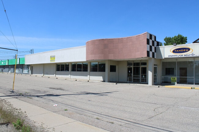
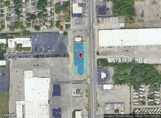
Property Record
3316 S Dort Hwy, Flint, MI 48507

NEARBY LISTINGS FOR SALE OR LEASE
Property Detail
3316 S Dort Hwy
41-20-476-045
UNPLATTED PART OF E 1/2 OF SE 1/4 OF SEC 20, T7N, R7E. BEG AT SW COR OF LOT 28 DORT ATHERTON THEATER PLAT; TH N 88 DEG 30 MIN
Commercialnec
Genesee
X
Michigan
26049C0307D
28
2024
1.36 AC
2025
Flint
003300
Detroit
32,108 SF
Flint, MI
DEMOGRAPHICS near 3316 S Dort Hwy
1 Mile
3 Mile
5 Mile
2024 Total Population
8,082
57,375
142,645
2029 Population
7,990
56,855
142,396
Pop Growth 2024-2029
(1.14%)
(0.91%)
(0.17%)
Average Age
35
39
39
2024 Total Households
3,208
24,042
59,080
HH Growth 2024-2029
(1.12%)
(0.96%)
(0.21%)
Median Household Inc
$32,991
$38,189
$42,469
Avg Household Size
2.40
2.30
2.30
2024 Avg HH Vehicles
1.00
1.00
2.00
Median Home Value
$71,484
$81,538
$96,967
Median Year Built
1959
1958
1961
Nearby Places
Map Layers
Map Styles
 Street
 Aerial
- Restaurants
- Banks
- Shops
- Fitness
- Groceries
PUBLIC TRANSPORTATION
COMMUTER RAIL
DRIVE
WALK
Distance
5 min
1.8 mi
AIRPORT
Bishop International
DRIVE
WALK
Distance
Bishop International
24 min
11.5 mi
SALE & LEASE HISTORY
LISTING DATE
SALE/LEASE

Sep 25, 2016
For Lease
Mar 06, 2018
For Sale
Jun 21, 2022
For Sale
Aug 23, 2017
For Lease
Nearby Properties
Address
Land Use
TOTAL SIZE
Lot Size
Zoning
Address
Land Use
TOTAL SIZE
Lot Size
Zoning
Address
Land Use
TOTAL SIZE
Lot Size
Zoning
290,267 SF
79 AC
PC
Address
Land Use
TOTAL SIZE
Lot Size
Zoning
130,291 SF
Address
Land Use
TOTAL SIZE
Lot Size
Zoning
227,755 SF
32.27 AC
C-2
Address
Land Use
TOTAL SIZE
Lot Size
Zoning
354,079 SF
48.41 AC
C-4
Address
Land Use
TOTAL SIZE
Lot Size
Zoning
144,896 SF
0.23 AC
DC
Address
Land Use
TOTAL SIZE
Lot Size
Zoning
115,556 SF
2.50 AC
DE
Address
Land Use
TOTAL SIZE
Lot Size
Zoning
371,636 SF
12.50 AC
M-1
Address
Land Use
TOTAL SIZE
Lot Size
Zoning
100,000 SF
Address
Land Use
TOTAL SIZE
Lot Size
Zoning
60,613 SF
12.91 AC
RO
Address
Land Use
TOTAL SIZE
Lot Size
Zoning
68,571 SF
0.81 AC
DC
Address
Land Use
TOTAL SIZE
Lot Size
Zoning
246,759 SF
19.03 AC
CC
Address
Land Use
TOTAL SIZE
Lot Size
Zoning
24.38 AC
RM
Address
Land Use
TOTAL SIZE
Lot Size
Zoning
91,726 SF
7.28 AC
HDM
Address
Land Use
TOTAL SIZE
Lot Size
Zoning
111,882 SF
5.36 AC
C-4
Address
Land Use
TOTAL SIZE
Lot Size
Zoning
419,038 SF
57.18 AC
M-2
Address
Land Use
TOTAL SIZE
Lot Size
Zoning
49,582 SF
25.15 AC
HRM
Address
Land Use
TOTAL SIZE
Lot Size
Zoning
364,289 SF
24.80 AC
GN-1
Address
Land Use
TOTAL SIZE
Lot Size
Zoning
136,506 SF
16.54 AC
C-4
Address
Land Use
TOTAL SIZE
Lot Size
Zoning
236,340 SF
25.17 AC
CE
Address
Land Use
TOTAL SIZE
Lot Size
Zoning
11.22 AC
RM
Address
Land Use
TOTAL SIZE
Lot Size
Zoning
2,321 SF
18.59 AC
M-1
Address
Land Use
TOTAL SIZE
Lot Size
Zoning
2,829 SF
75.78 AC
RMH
Address
Land Use
TOTAL SIZE
Lot Size
Zoning
85,697 SF
0.30 AC
DC
Address
Land Use
TOTAL SIZE
Lot Size
Zoning
123,170 SF
3.41 AC
DE
Address
Land Use
TOTAL SIZE
Lot Size
Zoning
62.08 AC
MHP
Address
Land Use
TOTAL SIZE
Lot Size
Zoning
65,488 SF
0.30 AC
DC
Address
Land Use
TOTAL SIZE
Lot Size
Zoning
320,622 SF
14.93 AC
M-2
Address
Land Use
TOTAL SIZE
Lot Size
Zoning
203,200 SF
0.92 AC
DE
Address
Land Use
TOTAL SIZE
Lot Size
Zoning
74,816 SF
The World's #1 Commercial Real Estate Marketplace
Connect with us
© 2025 CoStar Group
The information above has been obtained from sources believed reliable. While we do not doubt its accuracy we have not verified it and make no guarantee, warranty or representation about it. It is your responsibility to independently confirm its accuracy and completeness. Any projections, opinions, assumptions, or estimates used are for example only and do not represent the current or future performance of the property. The value of this transaction to you depends on tax and other factors which should be evaluated by your tax, financial, and legal advisors. You and your advisors should conduct a careful, independent investigation of the property to determine to your satisfaction the suitability of the property for your needs.