Property Record
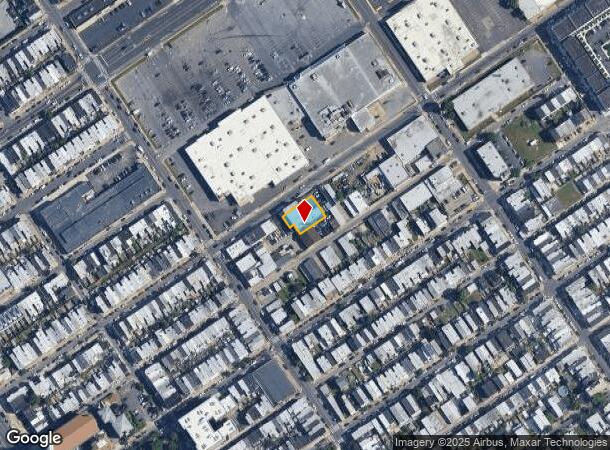
3317 Gaul St, Philadelphia, PA 19134
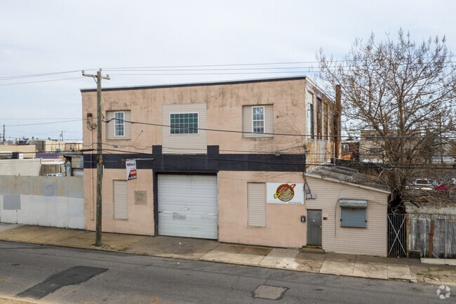
This Property Is For Sale
Current Lease Availabilities
NEARBY LISTINGS FOR SALE OR LEASE
Property Detail
3317 Gaul St
882021450
190.604 NE OF WESTMORELAN
Commercialnec
Philadelphia
X
Pennsylvania
34007C0026F
0.40 AC
2024
Kensington
2026
Philadelphia
037900
Philadelphia-Camden-Wilmington, PA-NJ-DE-MD
13,342 SF
DEMOGRAPHICS near 3317 Gaul St
1 Mile
3 Mile
5 Mile
2024 Total Population
39,227
305,078
912,512
2029 Population
38,100
297,703
890,369
Pop Growth 2024-2029
(2.87%)
(2.42%)
(2.43%)
Average Age
36
36
37
2024 Total Households
14,638
111,551
364,843
HH Growth 2024-2029
(3.14%)
(2.53%)
(2.57%)
Median Household Inc
$43,555
$41,589
$52,776
Avg Household Size
2.60
2.60
2.40
2024 Avg HH Vehicles
1.00
1.00
1.00
Median Home Value
$157,925
$164,510
$193,140
Median Year Built
1946
1947
1949
Nearby Places
- Restaurants
- Banks
- Shops
- Fitness
- Groceries
PUBLIC TRANSPORTATION
TRANSIT/SUBWAY
Richmond And Westmoreland (Route 15 - Southeastern Pennsylvania Transportation Authority Rapid Transit (SEPTA Subway & Trolley))
DRIVE
WALK
Distance
Richmond And Westmoreland (Route 15 - Southeastern Pennsylvania Transportation Authority Rapid Transit (SEPTA Subway & Trolley))
2 min
8 min
0.4 mi
Richmond St & Allegheny Av (63rd-Girard to Richmond-Westmorelnd - SEPTA)
DRIVE
WALK
Distance
Richmond St & Allegheny Av (63rd-Girard to Richmond-Westmorelnd - SEPTA)
2 min
10 min
0.5 mi
Richmond St & Clearfield St (63rd-Girard to Richmond-Westmorelnd - SEPTA)
DRIVE
WALK
Distance
Richmond St & Clearfield St (63rd-Girard to Richmond-Westmorelnd - SEPTA)
2 min
13 min
0.7 mi
Richmond St & Ann St (63rd-Girard to Richmond-Westmorelnd - SEPTA)
DRIVE
WALK
Distance
Richmond St & Ann St (63rd-Girard to Richmond-Westmorelnd - SEPTA)
3 min
17 min
0.9 mi
Richmond St & Cambria St (63rd-Girard to Richmond-Westmorelnd - SEPTA)
DRIVE
WALK
Distance
Richmond St & Cambria St (63rd-Girard to Richmond-Westmorelnd - SEPTA)
6 min
18 min
1.0 mi
COMMUTER RAIL
Bridesburg (R7 - Southeastern Pennsylvania Transportation Authority Regional Rail (SEPTA Regional Rail))
DRIVE
WALK
Distance
Bridesburg (R7 - Southeastern Pennsylvania Transportation Authority Regional Rail (SEPTA Regional Rail))
6 min
2.5 mi
Pennsauken Transit Center (Atlantic City Rail Line - NJ TRANSIT RAIL)
DRIVE
WALK
Distance
Pennsauken Transit Center (Atlantic City Rail Line - NJ TRANSIT RAIL)
14 min
7.0 mi
AIRPORT
Philadelphia International
DRIVE
WALK
Distance
Philadelphia International
25 min
15.1 mi
Trenton Mercer
DRIVE
WALK
Distance
Trenton Mercer
44 min
29.6 mi
Freight Ports
Port of Philadelphia
DRIVE
WALK
Distance
Port of Philadelphia
4 min
1.4 mi
Nearby Properties
Address
Land Use
TOTAL SIZE
Lot Size
Zoning
Address
Land Use
TOTAL SIZE
Lot Size
Zoning
880,950 SF
27.71 AC
SPENT
Address
Land Use
TOTAL SIZE
Lot Size
Zoning
1.88 AC
SPINS
Address
Land Use
TOTAL SIZE
Lot Size
Zoning
804,000 SF
4.29 AC
CMX3
Address
Land Use
TOTAL SIZE
Lot Size
Zoning
322,000 SF
7.44 AC
CMX3
Address
Land Use
TOTAL SIZE
Lot Size
Zoning
332,444 SF
1.32 AC
CMX3
Address
Land Use
TOTAL SIZE
Lot Size
Zoning
740,701 SF
47.70 AC
I2
Address
Land Use
TOTAL SIZE
Lot Size
Zoning
461,286 SF
2.64 AC
CMX4
Address
Land Use
TOTAL SIZE
Lot Size
Zoning
380,040 SF
1.22 AC
ICMX
Address
Land Use
TOTAL SIZE
Lot Size
Zoning
96,574 SF
2.42 AC
RM2
Address
Land Use
TOTAL SIZE
Lot Size
Zoning
458,556 SF
1.57 AC
CMX3
Address
Land Use
TOTAL SIZE
Lot Size
Zoning
485,616 SF
8.96 AC
CMX3
Address
Land Use
TOTAL SIZE
Lot Size
Zoning
242,655 SF
3.29 AC
CMX3
Address
Land Use
TOTAL SIZE
Lot Size
Zoning
8.50 AC
Address
Land Use
TOTAL SIZE
Lot Size
Zoning
324,477 SF
1.99 AC
CMX4
Address
Land Use
TOTAL SIZE
Lot Size
Zoning
293,510 SF
7.03 AC
SPINS
Address
Land Use
TOTAL SIZE
Lot Size
Zoning
17,886 SF
80 AC
SPPOA
Address
Land Use
TOTAL SIZE
Lot Size
Zoning
390,773 SF
2.86 AC
CMX3
Address
Land Use
TOTAL SIZE
Lot Size
Zoning
164,412 SF
4.44 AC
SPINS
Address
Land Use
TOTAL SIZE
Lot Size
Zoning
829,504 SF
4.77 AC
SPINS
Address
Land Use
TOTAL SIZE
Lot Size
Zoning
458,556 SF
1.39 AC
CMX3
Address
Land Use
TOTAL SIZE
Lot Size
Zoning
470,871 SF
41.87 AC
I3
Address
Land Use
TOTAL SIZE
Lot Size
Zoning
128,164 SF
6.82 AC
SPINS
Address
Land Use
TOTAL SIZE
Lot Size
Zoning
218,960 SF
1.55 AC
RM2
Address
Land Use
TOTAL SIZE
Lot Size
Zoning
163,400 SF
1.20 AC
CMX3
Address
Land Use
TOTAL SIZE
Lot Size
Zoning
500,000 SF
2.30 AC
CMX3
Address
Land Use
TOTAL SIZE
Lot Size
Zoning
209,503 SF
0.60 AC
CMX3
Address
Land Use
TOTAL SIZE
Lot Size
Zoning
265,000 SF
1.83 AC
CMX3
Address
Land Use
TOTAL SIZE
Lot Size
Zoning
235,276 SF
1.88 AC
CMX2.5
Address
Land Use
TOTAL SIZE
Lot Size
Zoning
561,600 SF
11.28 AC
CMX3
Address
Land Use
TOTAL SIZE
Lot Size
Zoning
184,842 SF
0.76 AC
CMX3
The World's #1 Commercial Real Estate Marketplace
Connect with us
© 2025 CoStar Group
The information above has been obtained from sources believed reliable. While we do not doubt its accuracy we have not verified it and make no guarantee, warranty or representation about it. It is your responsibility to independently confirm its accuracy and completeness. Any projections, opinions, assumptions, or estimates used are for example only and do not represent the current or future performance of the property. The value of this transaction to you depends on tax and other factors which should be evaluated by your tax, financial, and legal advisors. You and your advisors should conduct a careful, independent investigation of the property to determine to your satisfaction the suitability of the property for your needs.