Property Record
3317 Logan Dr, Oshkosh, WI 54901

Save to a Folder
{{folder.Name}}
{{folder.ListingIds.length}} Properties
{{folder.ListingIds.length}} Property
Create a New Folder
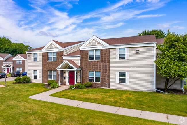
Property Detail
3317 Logan Dr
12-50184500
COM NE COR SE1/4 NE1/4 , TH WLY ALG N LI S SE1/4 NE1/41309.34 FT; TH S ALG W LI SD SE1/4 NE1/4 464.50 FT TO POB;TH CONT S ALG W LI SD SE1/4 NE1/4 717.38 FT; TH S89D5345
Commercialnec
Winnebago
MR-20-PD
Wisconsin
B and X Area of moderate flood hazard, usually the area between the limits of the 100-year and 500-year floods.
9.40 AC
2024
Appleton/Oshkosh
2025
Other Market Areas
001700
Oshkosh-Neenah, WI
135,562 SF
NEARBY LISTINGS FOR SALE OR LEASE
DEMOGRAPHICS near 3317 Logan Dr
1 mile
3 mile
5 mile
2025 Total Population
4,757
36,391
72,125
2030 Population
4,782
36,704
72,968
Pop Growth 2025-2030
+ 0.53%
+ 0.86%
+ 1.17%
Average Age
42
38
40
2025 Total Households
1,133
13,612
29,679
HH Growth 2025-2030
+ 1.68%
+ 1.17%
+ 1.37%
Median Household Inc
$80,086
$62,019
$63,897
Avg Household Size
2.40
2.20
2.20
2025 Avg HH Vehicles
2.00
2.00
2.00
Median Home Value
$247,386
$183,802
$193,429
Median Year Built
1990
1965
1971
Nearby Places
Map Layers
Map Styles
 Street
 Aerial
Layers
 Traffic
 Biking
Places
Listings with unknown addresses are not visible on the map
- Restaurants
- Banks
- Shops
- Fitness
- Groceries
PUBLIC TRANSPORTATION
AIRPORT
Appleton International
Drive
Walk
Distance
Appleton International
25 min
17.7 mi
Freight Ports
Port Milwaukee
Drive
Walk
Distance
Port Milwaukee
110 min
92.8 mi
Nearby Properties
Address
Land Use
TOTAL SIZE
Lot Size
Zoning
Address
Land Use
TOTAL SIZE
Lot Size
Zoning
32.81 AC
CBPPD
Address
Land Use
TOTAL SIZE
Lot Size
Zoning
552,602 SF
7.28 AC
M3
Address
Land Use
TOTAL SIZE
Lot Size
Zoning
485,007 SF
41.76 AC
M3
Address
Land Use
TOTAL SIZE
Lot Size
Zoning
195,847 SF
4.66 AC
UMU-PD
Address
Land Use
TOTAL SIZE
Lot Size
Zoning
2,316 SF
17.35 AC
MR-20-PD
Address
Land Use
TOTAL SIZE
Lot Size
Zoning
2.40 AC
CBP-PD
Address
Land Use
TOTAL SIZE
Lot Size
Zoning
70,335 SF
16 AC
HI
Address
Land Use
TOTAL SIZE
Lot Size
Zoning
152,505 SF
6.54 AC
MR-20-RFO
Address
Land Use
TOTAL SIZE
Lot Size
Zoning
84,363 SF
10.97 AC
C-2PD
Address
Land Use
TOTAL SIZE
Lot Size
Zoning
175,906 SF
11.60 AC
MR-20
Address
Land Use
TOTAL SIZE
Lot Size
Zoning
140,296 SF
13.58 AC
C-2
Address
Land Use
TOTAL SIZE
Lot Size
Zoning
366,482 SF
35.73 AC
M2
Address
Land Use
TOTAL SIZE
Lot Size
Zoning
4.76 AC
C2
Address
Land Use
TOTAL SIZE
Lot Size
Zoning
106,340 SF
5.37 AC
MR-20
Address
Land Use
TOTAL SIZE
Lot Size
Zoning
4.52 AC
SMU-PD
Address
Land Use
TOTAL SIZE
Lot Size
Zoning
96,928 SF
6.94 AC
MR-12
Address
Land Use
TOTAL SIZE
Lot Size
Zoning
179,700 SF
10.06 AC
M3
Address
Land Use
TOTAL SIZE
Lot Size
Zoning
37.96 AC
Address
Land Use
TOTAL SIZE
Lot Size
Zoning
71,538 SF
7.89 AC
I-PD
Address
Land Use
TOTAL SIZE
Lot Size
Zoning
76,815 SF
12.27 AC
C2
Address
Land Use
TOTAL SIZE
Lot Size
Zoning
621,225 SF
31.97 AC
M2
Address
Land Use
TOTAL SIZE
Lot Size
Zoning
71,610 SF
4.30 AC
MR-20
Address
Land Use
TOTAL SIZE
Lot Size
Zoning
24,751 SF
7.75 AC
C2
Address
Land Use
TOTAL SIZE
Lot Size
Zoning
62,266 SF
14.54 AC
HI
Address
Land Use
TOTAL SIZE
Lot Size
Zoning
14.92 AC
M1
Address
Land Use
TOTAL SIZE
Lot Size
Zoning
76,608 SF
3.45 AC
MR-20
Address
Land Use
TOTAL SIZE
Lot Size
Zoning
1.63 AC
SR2
Address
Land Use
TOTAL SIZE
Lot Size
Zoning
43,937 SF
1.97 AC
CBP-PD
Address
Land Use
TOTAL SIZE
Lot Size
Zoning
21.21 AC
B3
The World's #1 Commercial Real Estate Marketplace
Connect with us
© 2026 CoStar Group
The information above has been obtained from sources believed reliable. While we do not doubt its accuracy we have not verified it and make no guarantee, warranty or representation about it. It is your responsibility to independently confirm its accuracy and completeness. Any projections, opinions, assumptions, or estimates used are for example only and do not represent the current or future performance of the property. The value of this transaction to you depends on tax and other factors which should be evaluated by your tax, financial, and legal advisors. You and your advisors should conduct a careful, independent investigation of the property to determine to your satisfaction the suitability of the property for your needs.