Property Record
3319 E Us Highway 64, Lexington, NC 27292

NEARBY LISTINGS FOR SALE OR LEASE
-
-
View all Lexington listings for sale on LoopNet.com
Property Detail
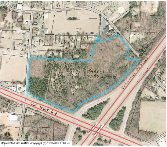
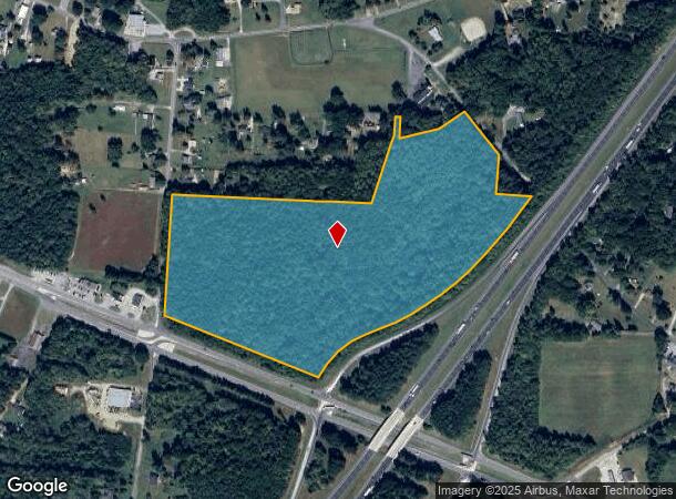
3319 E Us Highway 64
05-016-0-000-0109-0-0-0
L109 BK2381-1117 US 64
Vacantlandnec
Davidson
X
North Carolina
3710674500J
37.83 AC
2025
South Davidson County
2025
Greensboro/Winston-Salem
061805
Winston-Salem, NC
DEMOGRAPHICS near 3319 E Us Highway 64
1 Mile
3 Mile
5 Mile
2024 Total Population
838
6,756
32,670
2029 Population
871
7,053
34,552
Pop Growth 2024-2029
+ 3.94%
+ 4.40%
+ 5.76%
Average Age
43
42
41
2024 Total Households
356
2,690
13,118
HH Growth 2024-2029
+ 3.93%
+ 4.31%
+ 5.68%
Median Household Inc
$48,499
$45,568
$38,540
Avg Household Size
2.30
2.40
2.40
2024 Avg HH Vehicles
2.00
2.00
2.00
Median Home Value
$157,446
$160,449
$154,418
Median Year Built
1982
1979
1976
Nearby Places
Map Layers
Map Styles
 Street
 Aerial
- Restaurants
- Banks
- Shops
- Fitness
- Groceries
PUBLIC TRANSPORTATION
AIRPORT
Piedmont Triad International
DRIVE
WALK
Distance
Piedmont Triad International
48 min
36.0 mi
Freight Ports
Port of Wilmington
DRIVE
WALK
Distance
Port of Wilmington
252 min
209.5 mi
SALE & LEASE HISTORY
LISTING DATE
SALE/LEASE

Sep 24, 2016
For Sale
Nov 18, 2016
For Sale
Nearby Properties
Address
Land Use
TOTAL SIZE
Lot Size
Zoning
Address
Land Use
TOTAL SIZE
Lot Size
Zoning
4,788 SF
11.95 AC
HC
Address
Land Use
TOTAL SIZE
Lot Size
Zoning
84,523 SF
26.56 AC
RA1
Address
Land Use
TOTAL SIZE
Lot Size
Zoning
45,732 SF
5.82 AC
LI
Address
Land Use
TOTAL SIZE
Lot Size
Zoning
202.55 AC
LICZ
Address
Land Use
TOTAL SIZE
Lot Size
Zoning
128 SF
107.80 AC
PD
Address
Land Use
TOTAL SIZE
Lot Size
Zoning
41,784 SF
12.77 AC
OI
Address
Land Use
TOTAL SIZE
Lot Size
Zoning
14,648 SF
15.93 AC
OI
Address
Land Use
TOTAL SIZE
Lot Size
Zoning
19,061 SF
20.83 AC
OI
Address
Land Use
TOTAL SIZE
Lot Size
Zoning
7,080 SF
364.78 AC
RA3
Address
Land Use
TOTAL SIZE
Lot Size
Zoning
15,527 SF
3.03 AC
HC
Address
Land Use
TOTAL SIZE
Lot Size
Zoning
19,533 SF
2.71 AC
B
Address
Land Use
TOTAL SIZE
Lot Size
Zoning
8,883 SF
18.82 AC
RA2
Address
Land Use
TOTAL SIZE
Lot Size
Zoning
9,337 SF
6.98 AC
RA3
Address
Land Use
TOTAL SIZE
Lot Size
Zoning
68.73 AC
LICU
Address
Land Use
TOTAL SIZE
Lot Size
Zoning
10,847 SF
4.42 AC
HC
Address
Land Use
TOTAL SIZE
Lot Size
Zoning
32,525 SF
1.75 AC
HI
Address
Land Use
TOTAL SIZE
Lot Size
Zoning
11,349 SF
7.22 AC
RA3
Address
Land Use
TOTAL SIZE
Lot Size
Zoning
4,022 SF
5.80 AC
RA3
Address
Land Use
TOTAL SIZE
Lot Size
Zoning
49,270 SF
10.08 AC
HI
Address
Land Use
TOTAL SIZE
Lot Size
Zoning
10,584 SF
8.62 AC
RA1
Address
Land Use
TOTAL SIZE
Lot Size
Zoning
1,040 SF
95.18 AC
RA3
Address
Land Use
TOTAL SIZE
Lot Size
Zoning
5,596 SF
28.92 AC
LI
Address
Land Use
TOTAL SIZE
Lot Size
Zoning
9,894 SF
2 AC
HC
Address
Land Use
TOTAL SIZE
Lot Size
Zoning
12,133 SF
8.72 AC
RA2
Address
Land Use
TOTAL SIZE
Lot Size
Zoning
27,110 SF
4.47 AC
LI
Address
Land Use
TOTAL SIZE
Lot Size
Zoning
15,219 SF
15.10 AC
HI
Address
Land Use
TOTAL SIZE
Lot Size
Zoning
15,179 SF
2.13 AC
OI
Address
Land Use
TOTAL SIZE
Lot Size
Zoning
9,475 SF
14.25 AC
RA3
Address
Land Use
TOTAL SIZE
Lot Size
Zoning
4,907 SF
6.39 AC
HC
The World's #1 Commercial Real Estate Marketplace
Connect with us
© 2026 CoStar Group
The information above has been obtained from sources believed reliable. While we do not doubt its accuracy we have not verified it and make no guarantee, warranty or representation about it. It is your responsibility to independently confirm its accuracy and completeness. Any projections, opinions, assumptions, or estimates used are for example only and do not represent the current or future performance of the property. The value of this transaction to you depends on tax and other factors which should be evaluated by your tax, financial, and legal advisors. You and your advisors should conduct a careful, independent investigation of the property to determine to your satisfaction the suitability of the property for your needs.