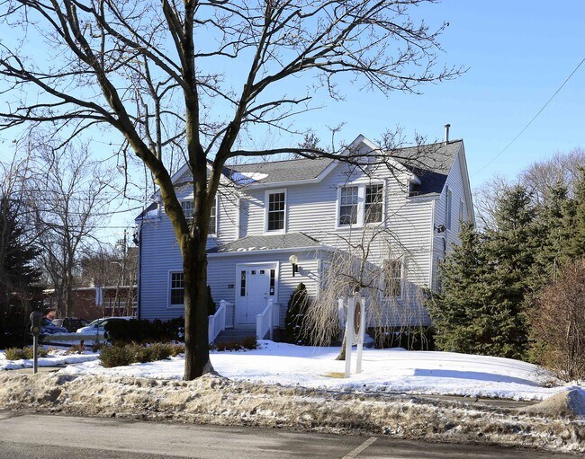
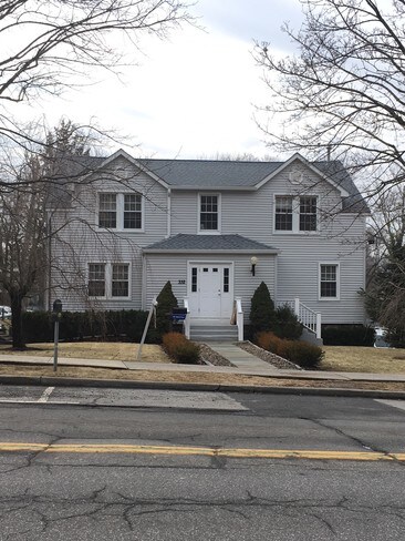
Property Record
332 E Main St, Mount Kisco, NY 10549

Property Detail
332 E Main St
5601-080-041-00003-000-0011
Westchester
Professionalbldglegalinsurancerealestateetc
New York
OD
11.000
B and X Area of moderate flood hazard, usually the area between the limits of the 100-year and 500-year floods.
0.54 AC
2025
North
2025
Westchester/So Connecticut
012900
New York-Jersey City-White Plains, NY-NJ
NEARBY LISTINGS FOR SALE OR LEASE
DEMOGRAPHICS near 332 E Main St
1 mile
3 mile
5 mile
2025 Total Population
9,304
23,186
60,604
2030 Population
9,274
23,453
61,409
Pop Growth 2025-2030
(0.32%)
+ 1.15%
+ 1.33%
Average Age
42
42
42
2025 Total Households
3,584
8,184
20,377
HH Growth 2025-2030
(0.22%)
+ 1.11%
+ 1.32%
Median Household Inc
$88,002
$140,994
$186,631
Avg Household Size
2.50
2.80
2.80
2025 Avg HH Vehicles
2.00
2.00
2.00
Median Home Value
$568,489
$784,049
$858,760
Median Year Built
1964
1966
1965
Nearby Places
Map Layers
Map Styles
 Street
 Aerial
Layers
 Traffic
 Biking
Places
Listings with unknown addresses are not visible on the map
- Restaurants
- Banks
- Shops
- Fitness
- Groceries
PUBLIC TRANSPORTATION
TRANSIT/SUBWAY
Mount Kisco Station (Harlem Line - Metro-North Commuter Railroad Company (Metro-North))
Drive
Walk
Distance
Mount Kisco Station (Harlem Line - Metro-North Commuter Railroad Company (Metro-North))
2 min
15 min
0.8 mi
COMMUTER RAIL
Mount Kisco Station (Harlem Line - Metro-North Commuter Railroad Company (Metro-North))
Drive
Walk
Distance
Mount Kisco Station (Harlem Line - Metro-North Commuter Railroad Company (Metro-North))
3 min
15 min
0.8 mi
Bedford Hills Station (Harlem Line - Metro-North Commuter Railroad Company (Metro-North))
Drive
Walk
Distance
Bedford Hills Station (Harlem Line - Metro-North Commuter Railroad Company (Metro-North))
7 min
3.6 mi
AIRPORT
Westchester County
Drive
Walk
Distance
Westchester County
18 min
11.9 mi
LaGuardia
Drive
Walk
Distance
LaGuardia
55 min
39.7 mi
New York Stewart International
Drive
Walk
Distance
New York Stewart International
72 min
41.9 mi
Freight Ports
NY - Red Hook Container Terminal
Drive
Walk
Distance
NY - Red Hook Container Terminal
68 min
47.9 mi
SALE & LEASE HISTORY
LISTING DATE
SALE/LEASE

Nov 10, 2017
For Lease
Nearby Properties
Address
Land Use
TOTAL SIZE
Lot Size
Zoning
Address
Land Use
TOTAL SIZE
Lot Size
Zoning
12.77 AC
H
Address
Land Use
TOTAL SIZE
Lot Size
Zoning
158.56 AC
Address
Land Use
TOTAL SIZE
Lot Size
Zoning
31 AC
ML
Address
Land Use
TOTAL SIZE
Lot Size
Zoning
20.54 AC
Address
Land Use
TOTAL SIZE
Lot Size
Zoning
450,000 SF
59.25 AC
Address
Land Use
TOTAL SIZE
Lot Size
Zoning
Address
Land Use
TOTAL SIZE
Lot Size
Zoning
85.40 AC
R-1A
Address
Land Use
TOTAL SIZE
Lot Size
Zoning
Address
Land Use
TOTAL SIZE
Lot Size
Zoning
4.86 AC
OG
Address
Land Use
TOTAL SIZE
Lot Size
Zoning
3.70 AC
OG
Address
Land Use
TOTAL SIZE
Lot Size
Zoning
4.29 AC
OG
Address
Land Use
TOTAL SIZE
Lot Size
Zoning
2.20 AC
CB-2
Address
Land Use
TOTAL SIZE
Lot Size
Zoning
11.71 AC
Address
Land Use
TOTAL SIZE
Lot Size
Zoning
25 AC
R-1A
Address
Land Use
TOTAL SIZE
Lot Size
Zoning
143.80 AC
Address
Land Use
TOTAL SIZE
Lot Size
Zoning
7.62 AC
RM-29
Address
Land Use
TOTAL SIZE
Lot Size
Zoning
100,000 SF
0.79 AC
Address
Land Use
TOTAL SIZE
Lot Size
Zoning
3.67 AC
CL
Address
Land Use
TOTAL SIZE
Lot Size
Zoning
3.13 AC
MG
Address
Land Use
TOTAL SIZE
Lot Size
Zoning
2.20 AC
CB-2
Address
Land Use
TOTAL SIZE
Lot Size
Zoning
3,814 SF
97.89 AC
R-2A
Address
Land Use
TOTAL SIZE
Lot Size
Zoning
2.05 AC
RT-6
Address
Land Use
TOTAL SIZE
Lot Size
Zoning
Address
Land Use
TOTAL SIZE
Lot Size
Zoning
6.26 AC
GC
Address
Land Use
TOTAL SIZE
Lot Size
Zoning
2.38 AC
CR
Address
Land Use
TOTAL SIZE
Lot Size
Zoning
4.20 AC
MG
Address
Land Use
TOTAL SIZE
Lot Size
Zoning
1,476 SF
8.15 AC
BR
Address
Land Use
TOTAL SIZE
Lot Size
Zoning
3.21 AC
CL
Address
Land Use
TOTAL SIZE
Lot Size
Zoning
3.99 AC
RT-6
Address
Land Use
TOTAL SIZE
Lot Size
Zoning
1.64 AC
MRD
The World's #1 Commercial Real Estate Marketplace
Connect with us
© 2026 CoStar Group
The information above has been obtained from sources believed reliable. While we do not doubt its accuracy we have not verified it and make no guarantee, warranty or representation about it. It is your responsibility to independently confirm its accuracy and completeness. Any projections, opinions, assumptions, or estimates used are for example only and do not represent the current or future performance of the property. The value of this transaction to you depends on tax and other factors which should be evaluated by your tax, financial, and legal advisors. You and your advisors should conduct a careful, independent investigation of the property to determine to your satisfaction the suitability of the property for your needs.