Property Record
335 Route 202, Somers, NY 10589
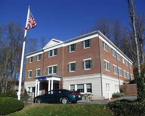
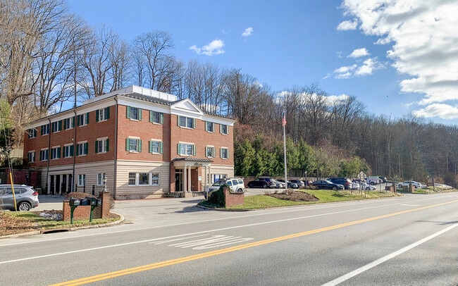

This Property Is For Sale
NEARBY LISTINGS FOR SALE OR LEASE
Property Detail
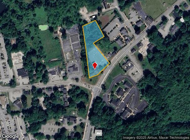
335 Route 202
5200-017-011-00001-000-0020
Westchester
Officebuilding
New York
X
20.000
36119C0058F
1.67 AC
0
North
2024
Westchester/So Connecticut
014909
New York-Jersey City-White Plains, NY-NJ
8,448 SF
DEMOGRAPHICS near 335 Route 202
1 Mile
3 Mile
5 Mile
2024 Total Population
3,937
19,920
46,720
2029 Population
3,889
19,614
46,048
Pop Growth 2024-2029
(1.22%)
(1.54%)
(1.44%)
Average Age
53
49
45
2024 Total Households
1,894
8,055
17,561
HH Growth 2024-2029
(1.58%)
(1.44%)
(1.42%)
Median Household Inc
$120,569
$133,830
$135,410
Avg Household Size
2.00
2.40
2.60
2024 Avg HH Vehicles
2.00
2.00
2.00
Median Home Value
$484,079
$514,574
$527,935
Median Year Built
1976
1977
1973
Nearby Places
- Restaurants
- Banks
- Shops
- Fitness
- Groceries
PUBLIC TRANSPORTATION
COMMUTER RAIL
Purdy's Station (Harlem Line - Metro-North Commuter Railroad Company (Metro-North))
DRIVE
WALK
Distance
Purdy's Station (Harlem Line - Metro-North Commuter Railroad Company (Metro-North))
4 min
1.7 mi
Croton Falls Station (Harlem Line - Metro-North Commuter Railroad Company (Metro-North))
DRIVE
WALK
Distance
Croton Falls Station (Harlem Line - Metro-North Commuter Railroad Company (Metro-North))
4 min
2.2 mi
AIRPORT
Westchester County
DRIVE
WALK
Distance
Westchester County
27 min
19.6 mi
New York Stewart International
DRIVE
WALK
Distance
New York Stewart International
61 min
44.0 mi
Freight Ports
Port of New Haven
DRIVE
WALK
Distance
Port of New Haven
77 min
52.0 mi
Nearby Properties
Address
Land Use
TOTAL SIZE
Lot Size
Zoning
Address
Land Use
TOTAL SIZE
Lot Size
Zoning
20,298 SF
331.64 AC
NW
Address
Land Use
TOTAL SIZE
Lot Size
Zoning
38.19 AC
Address
Land Use
TOTAL SIZE
Lot Size
Zoning
1,193 SF
94.75 AC
NW
Address
Land Use
TOTAL SIZE
Lot Size
Zoning
1,078,069 SF
723.08 AC
Address
Land Use
TOTAL SIZE
Lot Size
Zoning
447.03 AC
R-120
Address
Land Use
TOTAL SIZE
Lot Size
Zoning
Address
Land Use
TOTAL SIZE
Lot Size
Zoning
10 AC
Address
Land Use
TOTAL SIZE
Lot Size
Zoning
864 SF
4.77 AC
R
Address
Land Use
TOTAL SIZE
Lot Size
Zoning
Address
Land Use
TOTAL SIZE
Lot Size
Zoning
172.78 AC
Address
Land Use
TOTAL SIZE
Lot Size
Zoning
98.59 AC
Address
Land Use
TOTAL SIZE
Lot Size
Zoning
150.67 AC
Address
Land Use
TOTAL SIZE
Lot Size
Zoning
120.59 AC
Address
Land Use
TOTAL SIZE
Lot Size
Zoning
1,984 SF
17.90 AC
R-120
Address
Land Use
TOTAL SIZE
Lot Size
Zoning
19.11 AC
Address
Land Use
TOTAL SIZE
Lot Size
Zoning
2,996 SF
25.88 AC
RO
Address
Land Use
TOTAL SIZE
Lot Size
Zoning
114.82 AC
Address
Land Use
TOTAL SIZE
Lot Size
Zoning
38.98 AC
Address
Land Use
TOTAL SIZE
Lot Size
Zoning
93.51 AC
Address
Land Use
TOTAL SIZE
Lot Size
Zoning
30.81 AC
Address
Land Use
TOTAL SIZE
Lot Size
Zoning
11.80 AC
Address
Land Use
TOTAL SIZE
Lot Size
Zoning
2,431 SF
58.02 AC
R-80
Address
Land Use
TOTAL SIZE
Lot Size
Zoning
10.79 AC
NS
Address
Land Use
TOTAL SIZE
Lot Size
Zoning
69.12 AC
Address
Land Use
TOTAL SIZE
Lot Size
Zoning
37,619 SF
9.93 AC
GC-2
Address
Land Use
TOTAL SIZE
Lot Size
Zoning
1.61 AC
R
Address
Land Use
TOTAL SIZE
Lot Size
Zoning
30.01 AC
Address
Land Use
TOTAL SIZE
Lot Size
Zoning
9.06 AC
Address
Land Use
TOTAL SIZE
Lot Size
Zoning
Address
Land Use
TOTAL SIZE
Lot Size
Zoning
1,795 SF
25.31 AC
R-120
The World's #1 Commercial Real Estate Marketplace
Connect with us
© 2025 CoStar Group
The information above has been obtained from sources believed reliable. While we do not doubt its accuracy we have not verified it and make no guarantee, warranty or representation about it. It is your responsibility to independently confirm its accuracy and completeness. Any projections, opinions, assumptions, or estimates used are for example only and do not represent the current or future performance of the property. The value of this transaction to you depends on tax and other factors which should be evaluated by your tax, financial, and legal advisors. You and your advisors should conduct a careful, independent investigation of the property to determine to your satisfaction the suitability of the property for your needs.