Property Record
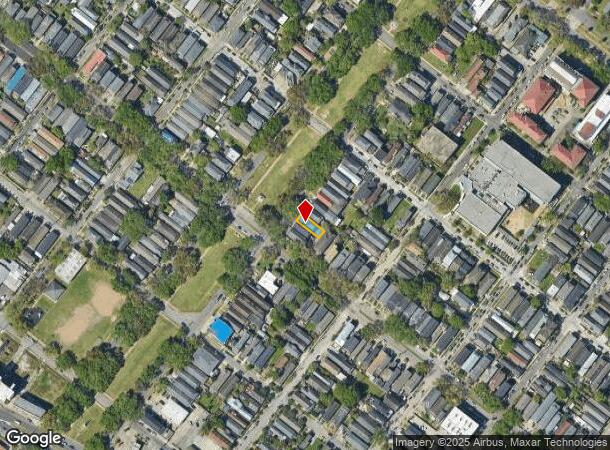
332 S Norman C Francis Pkwy, New Orleans, LA 70119
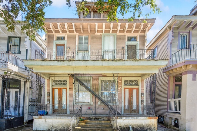
This Property Is For Sale
NEARBY LISTINGS FOR SALE OR LEASE
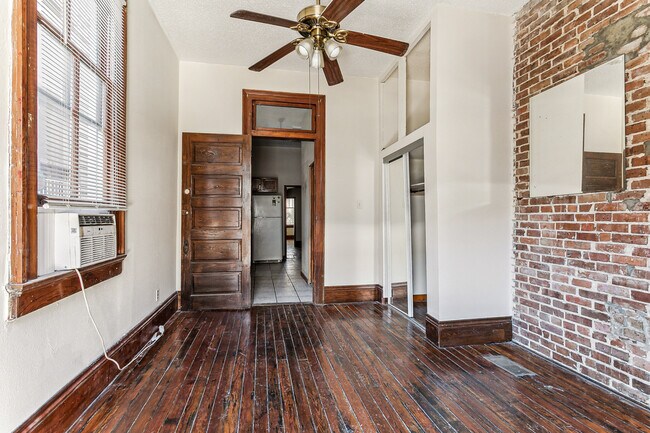
Property Detail
332 S Norman C Francis Pkwy
New Orleans-Metairie, LA
Orleans
1-05-2-064-27
Louisiana
Duplex
0.07 AC
AE
Mid-City
22051C0225F
New Orleans/Metairie/Kenner
2,950 SF
DEMOGRAPHICS near 332 S Norman C Francis Pkwy
1 Mile
3 Mile
5 Mile
2024 Total Population
22,779
176,325
348,477
2029 Population
22,166
171,245
336,991
Pop Growth 2024-2029
(2.69%)
(2.88%)
(3.30%)
Average Age
38
41
41
2024 Total Households
10,450
82,933
158,914
HH Growth 2024-2029
(3.06%)
(2.77%)
(3.32%)
Median Household Inc
$44,907
$53,328
$54,171
Avg Household Size
1.90
2.00
2.10
2024 Avg HH Vehicles
1.00
1.00
1.00
Median Home Value
$354,201
$392,245
$333,963
Median Year Built
1947
1948
1954
Nearby Places
- Restaurants
- Banks
- Shops
- Fitness
- Groceries
PUBLIC TRANSPORTATION
TRANSIT/SUBWAY
Canal and Jefferson Davis Pkwy (Canal-Cemeteries Streetcar - New Orleans Regional Transit Authority Streetcars (New Orleans Streetcars), Canal-Museum Streetcar - New Orleans Regional Transit Authority Streetcars (New Orleans Streetcars))
DRIVE
WALK
Distance
Canal and Jefferson Davis Pkwy (Canal-Cemeteries Streetcar - New Orleans Regional Transit Authority Streetcars (New Orleans Streetcars), Canal-Museum Streetcar - New Orleans Regional Transit Authority Streetcars (New Orleans Streetcars))
1 min
5 min
0.3 mi
Canal and Lopez (Canal-Cemeteries Streetcar - New Orleans Regional Transit Authority Streetcars (New Orleans Streetcars), Canal-Museum Streetcar - New Orleans Regional Transit Authority Streetcars (New Orleans Streetcars))
DRIVE
WALK
Distance
Canal and Lopez (Canal-Cemeteries Streetcar - New Orleans Regional Transit Authority Streetcars (New Orleans Streetcars), Canal-Museum Streetcar - New Orleans Regional Transit Authority Streetcars (New Orleans Streetcars))
1 min
7 min
0.3 mi
Canal and Clark (Canal-Cemeteries Streetcar - New Orleans Regional Transit Authority Streetcars (New Orleans Streetcars), Canal-Museum Streetcar - New Orleans Regional Transit Authority Streetcars (New Orleans Streetcars))
DRIVE
WALK
Distance
Canal and Clark (Canal-Cemeteries Streetcar - New Orleans Regional Transit Authority Streetcars (New Orleans Streetcars), Canal-Museum Streetcar - New Orleans Regional Transit Authority Streetcars (New Orleans Streetcars))
1 min
7 min
0.4 mi
Canal and Salcedo (Canal-Cemeteries Streetcar - New Orleans Regional Transit Authority Streetcars (New Orleans Streetcars), Canal-Museum Streetcar - New Orleans Regional Transit Authority Streetcars (New Orleans Streetcars))
DRIVE
WALK
Distance
Canal and Salcedo (Canal-Cemeteries Streetcar - New Orleans Regional Transit Authority Streetcars (New Orleans Streetcars), Canal-Museum Streetcar - New Orleans Regional Transit Authority Streetcars (New Orleans Streetcars))
2 min
8 min
0.4 mi
Canal and Gayoso (Canal-Cemeteries Streetcar - New Orleans Regional Transit Authority Streetcars (New Orleans Streetcars), Canal-Museum Streetcar - New Orleans Regional Transit Authority Streetcars (New Orleans Streetcars))
DRIVE
WALK
Distance
Canal and Gayoso (Canal-Cemeteries Streetcar - New Orleans Regional Transit Authority Streetcars (New Orleans Streetcars), Canal-Museum Streetcar - New Orleans Regional Transit Authority Streetcars (New Orleans Streetcars))
1 min
9 min
0.5 mi
COMMUTER RAIL
DRIVE
WALK
Distance
6 min
2.4 mi
AIRPORT
Louis Armstrong New Orleans International
DRIVE
WALK
Distance
Louis Armstrong New Orleans International
20 min
13.0 mi
Nearby Properties
Address
Land Use
TOTAL SIZE
Lot Size
Zoning
Address
Land Use
TOTAL SIZE
Lot Size
Zoning
300 SF
2.19 AC
LS
Address
Land Use
TOTAL SIZE
Lot Size
Zoning
85,052 SF
2.19 AC
LS
Address
Land Use
TOTAL SIZE
Lot Size
Zoning
80.92 AC
EC
Address
Land Use
TOTAL SIZE
Lot Size
Zoning
44.43 AC
CBD-4
Address
Land Use
TOTAL SIZE
Lot Size
Zoning
22.63 AC
Address
Land Use
TOTAL SIZE
Lot Size
Zoning
66.23 AC
CBD-4
Address
Land Use
TOTAL SIZE
Lot Size
Zoning
3.66 AC
MC
Address
Land Use
TOTAL SIZE
Lot Size
Zoning
834,043 SF
1.40 AC
CBD-2
Address
Land Use
TOTAL SIZE
Lot Size
Zoning
18.31 AC
CBD-4
Address
Land Use
TOTAL SIZE
Lot Size
Zoning
1.87 AC
CBD-2
Address
Land Use
TOTAL SIZE
Lot Size
Zoning
844,362 SF
5.85 AC
CBD-4
Address
Land Use
TOTAL SIZE
Lot Size
Zoning
444,121 SF
1.46 AC
CBD-1
Address
Land Use
TOTAL SIZE
Lot Size
Zoning
0.88 AC
CBD-2
Address
Land Use
TOTAL SIZE
Lot Size
Zoning
725,677 SF
54.19 AC
EC
Address
Land Use
TOTAL SIZE
Lot Size
Zoning
1.91 AC
CBD-1
Address
Land Use
TOTAL SIZE
Lot Size
Zoning
576,962 SF
3.31 AC
CBD-4
Address
Land Use
TOTAL SIZE
Lot Size
Zoning
1.79 AC
Address
Land Use
TOTAL SIZE
Lot Size
Zoning
609,449 SF
2 AC
EC
Address
Land Use
TOTAL SIZE
Lot Size
Zoning
512,729 SF
6.60 AC
Address
Land Use
TOTAL SIZE
Lot Size
Zoning
1.24 AC
CBD-1
Address
Land Use
TOTAL SIZE
Lot Size
Zoning
190,708 SF
1.09 AC
CBD-2
Address
Land Use
TOTAL SIZE
Lot Size
Zoning
225,284 SF
16.83 AC
S-RD
Address
Land Use
TOTAL SIZE
Lot Size
Zoning
499,287 SF
1.44 AC
VCE
Address
Land Use
TOTAL SIZE
Lot Size
Zoning
0.67 AC
CBD-3
Address
Land Use
TOTAL SIZE
Lot Size
Zoning
162,382 SF
1.25 AC
CBD-2
Address
Land Use
TOTAL SIZE
Lot Size
Zoning
35.06 AC
Address
Land Use
TOTAL SIZE
Lot Size
Zoning
258,024 SF
0.63 AC
CBD-2
Address
Land Use
TOTAL SIZE
Lot Size
Zoning
2.94 AC
CBD-1
Address
Land Use
TOTAL SIZE
Lot Size
Zoning
3.36 AC
EC
Address
Land Use
TOTAL SIZE
Lot Size
Zoning
462,672 SF
1.11 AC
CBD-1
The World's #1 Commercial Real Estate Marketplace
Connect with us
© 2025 CoStar Group
The information above has been obtained from sources believed reliable. While we do not doubt its accuracy we have not verified it and make no guarantee, warranty or representation about it. It is your responsibility to independently confirm its accuracy and completeness. Any projections, opinions, assumptions, or estimates used are for example only and do not represent the current or future performance of the property. The value of this transaction to you depends on tax and other factors which should be evaluated by your tax, financial, and legal advisors. You and your advisors should conduct a careful, independent investigation of the property to determine to your satisfaction the suitability of the property for your needs.