Property Record
332 Springvale Rd, Great Falls, VA 22066
NEARBY LISTINGS FOR SALE OR LEASE
Property Detail
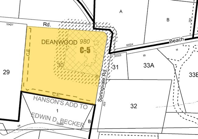
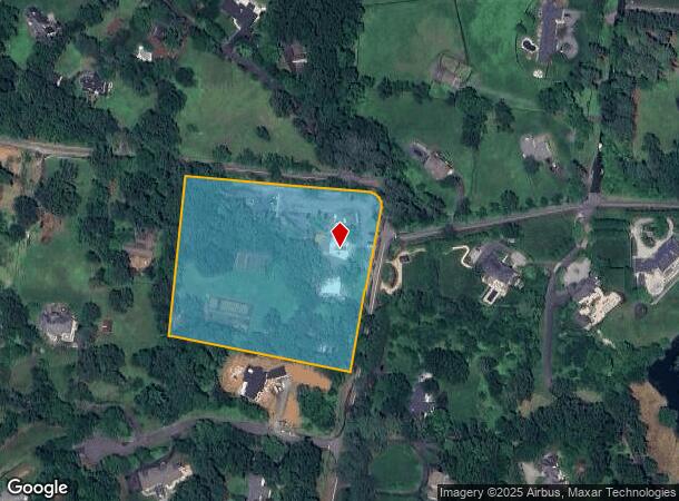
332 Springvale Rd
Washington-Arlington-Alexandria, DC-VA-MD-WV
Potomac
0034-01-0030
POTOMAC
Restaurantbuilding
Fairfax
X
Virginia
51059C0045E
30
2024
5.70 AC
2025
Great Falls
480402
Washington, DC
9,523 SF
DEMOGRAPHICS near 332 Springvale Rd
1 Mile
3 Mile
5 Mile
2024 Total Population
1,471
21,392
101,430
2029 Population
1,452
21,745
103,593
Pop Growth 2024-2029
(1.29%)
+ 1.65%
+ 2.13%
Average Age
43
42
41
2024 Total Households
470
6,975
34,804
HH Growth 2024-2029
(1.49%)
+ 1.76%
+ 1.89%
Median Household Inc
$249,359
$226,381
$170,827
Avg Household Size
3.10
3.00
2.80
2024 Avg HH Vehicles
2.00
3.00
2.00
Median Home Value
$1,109,798
$991,960
$766,213
Median Year Built
1984
1990
1986
Nearby Places
Map Layers
Map Styles
 Street
 Aerial
- Restaurants
- Banks
- Shops
- Fitness
- Groceries
PUBLIC TRANSPORTATION
AIRPORT
Washington Dulles International
DRIVE
WALK
Distance
Washington Dulles International
28 min
13.0 mi
Ronald Reagan Washington Ntl
DRIVE
WALK
Distance
Ronald Reagan Washington Ntl
42 min
25.6 mi
Freight Ports
Port of Baltimore
DRIVE
WALK
Distance
Port of Baltimore
80 min
53.8 mi
Nearby Properties
Address
Land Use
TOTAL SIZE
Lot Size
Zoning
Address
Land Use
TOTAL SIZE
Lot Size
Zoning
233.03 AC
100
Address
Land Use
TOTAL SIZE
Lot Size
Zoning
77,704 SF
487.22 AC
PDH4
Address
Land Use
TOTAL SIZE
Lot Size
Zoning
75,524 SF
90.33 AC
100
Address
Land Use
TOTAL SIZE
Lot Size
Zoning
85,600 SF
10.29 AC
CCSC
Address
Land Use
TOTAL SIZE
Lot Size
Zoning
130.56 AC
100
Address
Land Use
TOTAL SIZE
Lot Size
Zoning
47,598 SF
5.68 AC
497
Address
Land Use
TOTAL SIZE
Lot Size
Zoning
34.88 AC
RE2
Address
Land Use
TOTAL SIZE
Lot Size
Zoning
77,272 SF
15.88 AC
PDH4
Address
Land Use
TOTAL SIZE
Lot Size
Zoning
240.84 AC
100
Address
Land Use
TOTAL SIZE
Lot Size
Zoning
7.19 AC
PDH4
Address
Land Use
TOTAL SIZE
Lot Size
Zoning
13,851 SF
3.55 AC
480
Address
Land Use
TOTAL SIZE
Lot Size
Zoning
1,440 SF
85 AC
100
Address
Land Use
TOTAL SIZE
Lot Size
Zoning
31,196 SF
0.67 AC
480
Address
Land Use
TOTAL SIZE
Lot Size
Zoning
27,918 SF
4.86 AC
110
Address
Land Use
TOTAL SIZE
Lot Size
Zoning
122.52 AC
100
Address
Land Use
TOTAL SIZE
Lot Size
Zoning
26,633 SF
2.41 AC
450
Address
Land Use
TOTAL SIZE
Lot Size
Zoning
72,844 SF
5.08 AC
110
Address
Land Use
TOTAL SIZE
Lot Size
Zoning
32.49 AC
100
Address
Land Use
TOTAL SIZE
Lot Size
Zoning
12,983 SF
8.21 AC
497
Address
Land Use
TOTAL SIZE
Lot Size
Zoning
20,293 SF
2.03 AC
480
Address
Land Use
TOTAL SIZE
Lot Size
Zoning
23,516 SF
21.38 AC
RE2
Address
Land Use
TOTAL SIZE
Lot Size
Zoning
18,649 SF
5.02 AC
100
Address
Land Use
TOTAL SIZE
Lot Size
Zoning
18,406 SF
10.77 AC
PDH4
Address
Land Use
TOTAL SIZE
Lot Size
Zoning
12,351 SF
1.41 AC
480
Address
Land Use
TOTAL SIZE
Lot Size
Zoning
90,566 SF
10.20 AC
100
Address
Land Use
TOTAL SIZE
Lot Size
Zoning
25,128 SF
9.43 AC
100
Address
Land Use
TOTAL SIZE
Lot Size
Zoning
3,360 SF
18.01 AC
100
Address
Land Use
TOTAL SIZE
Lot Size
Zoning
24,728 SF
1.69 AC
497
Address
Land Use
TOTAL SIZE
Lot Size
Zoning
35,377 SF
6.85 AC
110
Address
Land Use
TOTAL SIZE
Lot Size
Zoning
1,208 SF
32.97 AC
110
The World's #1 Commercial Real Estate Marketplace
Connect with us
© 2026 CoStar Group
The information above has been obtained from sources believed reliable. While we do not doubt its accuracy we have not verified it and make no guarantee, warranty or representation about it. It is your responsibility to independently confirm its accuracy and completeness. Any projections, opinions, assumptions, or estimates used are for example only and do not represent the current or future performance of the property. The value of this transaction to you depends on tax and other factors which should be evaluated by your tax, financial, and legal advisors. You and your advisors should conduct a careful, independent investigation of the property to determine to your satisfaction the suitability of the property for your needs.