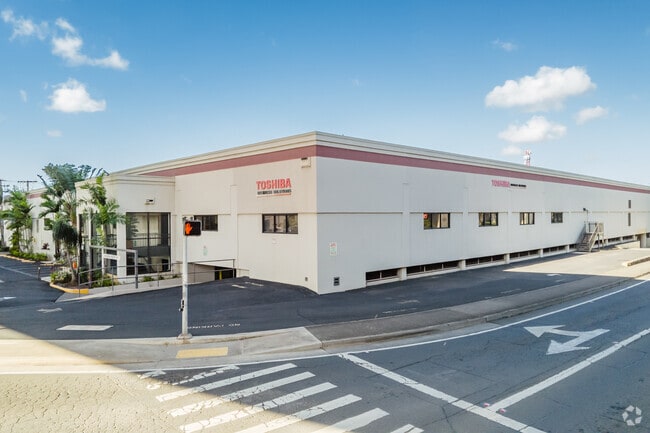
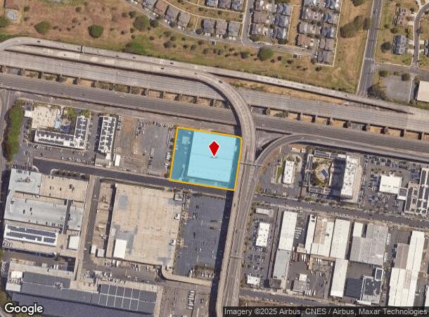
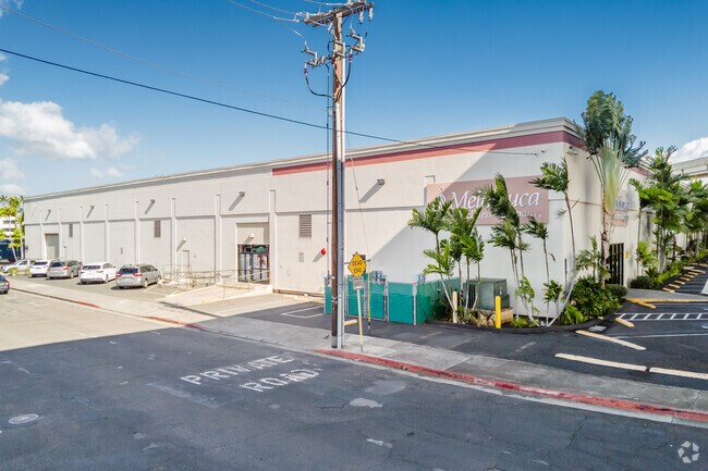
Property Record
3324 Koapaka St, Honolulu, HI 96819
NEARBY LISTINGS FOR SALE OR LEASE
Property Detail
3324 Koapaka St
1-1-1-015-004-0000
LOT 3861 95148 SF OR 2.184 ACRES MAP 682 LCAPP 1074 TOG/ R/O/W RDWY PURP OVER LOT 1125-B-6-A SUBJ/ALL IMPRVMTS WITHIN LOT 1125-A-2 FOC CIV NO 50078
Industrialgeneral
Honolulu
D
Hawaii
15003C0334G
3861
2024
2.18 AC
2025
Leeward
006203
Hawaii
149,013 SF
Urban Honolulu, HI
DEMOGRAPHICS near 3324 Koapaka St
1 Mile
3 Mile
5 Mile
2024 Total Population
19,802
97,356
236,780
2029 Population
19,261
94,530
230,172
Pop Growth 2024-2029
(2.73%)
(2.90%)
(2.79%)
Average Age
37
37
40
2024 Total Households
6,763
27,509
79,617
HH Growth 2024-2029
(3.28%)
(3.42%)
(3.00%)
Median Household Inc
$81,342
$87,444
$83,396
Avg Household Size
2.90
3.10
2.70
2024 Avg HH Vehicles
2.00
2.00
2.00
Median Home Value
$471,474
$733,116
$725,007
Median Year Built
1978
1976
1976
Nearby Places
Map Layers
Map Styles
 Street
 Aerial
- Restaurants
- Banks
- Shops
- Fitness
- Groceries
PUBLIC TRANSPORTATION
AIRPORT
Daniel K Inouye International
DRIVE
WALK
Distance
Daniel K Inouye International
4 min
1.1 mi
Freight Ports
Honolulu Harbor, Oahu
DRIVE
WALK
Distance
Honolulu Harbor, Oahu
11 min
4.6 mi
SALE & LEASE HISTORY
LISTING DATE
SALE/LEASE

Sep 25, 2016
For Lease
Jan 22, 2019
For Lease
Nearby Properties
Address
Land Use
TOTAL SIZE
Lot Size
Zoning
Address
Land Use
TOTAL SIZE
Lot Size
Zoning
1,675.63 AC
C/61/60
Address
Land Use
TOTAL SIZE
Lot Size
Zoning
355.21 AC
F-1
Address
Land Use
TOTAL SIZE
Lot Size
Zoning
1,725,655 SF
11 AC
I-2
Address
Land Use
TOTAL SIZE
Lot Size
Zoning
1,725,655 SF
11 AC
I-2
Address
Land Use
TOTAL SIZE
Lot Size
Zoning
12,430 SF
86.69 AC
I-3
Address
Land Use
TOTAL SIZE
Lot Size
Zoning
163,285 SF
15.08 AC
R-7.5
Address
Land Use
TOTAL SIZE
Lot Size
Zoning
26,537 SF
2,470.86 AC
I-2
Address
Land Use
TOTAL SIZE
Lot Size
Zoning
1,447,909 SF
12.54 AC
IMX-1
Address
Land Use
TOTAL SIZE
Lot Size
Zoning
919,972 SF
14.45 AC
I-2
Address
Land Use
TOTAL SIZE
Lot Size
Zoning
6.20 AC
I-2
Address
Land Use
TOTAL SIZE
Lot Size
Zoning
960 SF
71.97 AC
P-2
Address
Land Use
TOTAL SIZE
Lot Size
Zoning
16.46 AC
I-2
Address
Land Use
TOTAL SIZE
Lot Size
Zoning
267,131 SF
6.06 AC
I-2
Address
Land Use
TOTAL SIZE
Lot Size
Zoning
347,039 SF
12.61 AC
IMX-1
Address
Land Use
TOTAL SIZE
Lot Size
Zoning
12.54 AC
IMX-1
Address
Land Use
TOTAL SIZE
Lot Size
Zoning
9.58 AC
IMX-1
Address
Land Use
TOTAL SIZE
Lot Size
Zoning
154,018 SF
15.24 AC
F-1
Address
Land Use
TOTAL SIZE
Lot Size
Zoning
12.47 AC
F-1
Address
Land Use
TOTAL SIZE
Lot Size
Zoning
57,554 SF
10.05 AC
I-2
Address
Land Use
TOTAL SIZE
Lot Size
Zoning
14,553 SF
14.57 AC
B-2
Address
Land Use
TOTAL SIZE
Lot Size
Zoning
117,641 SF
9.61 AC
B-2
Address
Land Use
TOTAL SIZE
Lot Size
Zoning
245,081 SF
11.42 AC
IMX-1
Address
Land Use
TOTAL SIZE
Lot Size
Zoning
292,595 SF
3.12 AC
I-2
Address
Land Use
TOTAL SIZE
Lot Size
Zoning
299,696 SF
16.26 AC
BMX-3
Address
Land Use
TOTAL SIZE
Lot Size
Zoning
398,950 SF
3.97 AC
IMX-1
Address
Land Use
TOTAL SIZE
Lot Size
Zoning
100,170 SF
6.85 AC
IMX-1
Address
Land Use
TOTAL SIZE
Lot Size
Zoning
236,500 SF
5.41 AC
I-2
Address
Land Use
TOTAL SIZE
Lot Size
Zoning
165,493 SF
6.85 AC
B-2
Address
Land Use
TOTAL SIZE
Lot Size
Zoning
157,979 SF
5.71 AC
IMX-1
Address
Land Use
TOTAL SIZE
Lot Size
Zoning
358,916 SF
5.25 AC
IMX-1
The World's #1 Commercial Real Estate Marketplace
Connect with us
© 2025 CoStar Group
The information above has been obtained from sources believed reliable. While we do not doubt its accuracy we have not verified it and make no guarantee, warranty or representation about it. It is your responsibility to independently confirm its accuracy and completeness. Any projections, opinions, assumptions, or estimates used are for example only and do not represent the current or future performance of the property. The value of this transaction to you depends on tax and other factors which should be evaluated by your tax, financial, and legal advisors. You and your advisors should conduct a careful, independent investigation of the property to determine to your satisfaction the suitability of the property for your needs.