Property Record
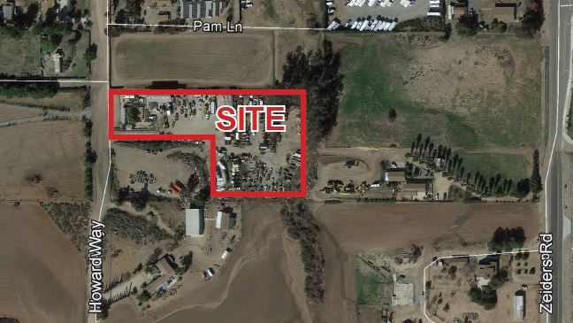
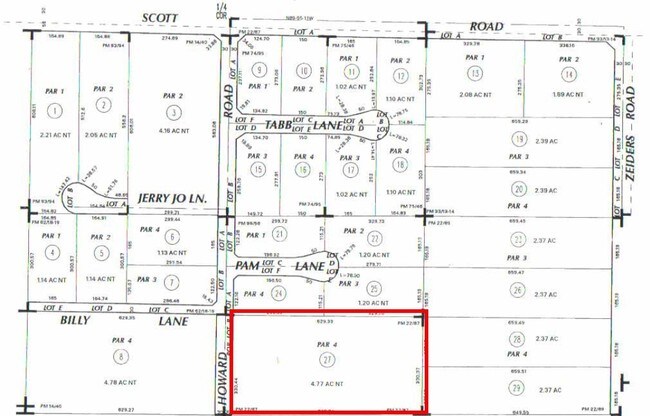
33250 Howard Rd, Menifee, CA 92584

Property Detail
33250 Howard Rd
384-130-027
4.77 ACRES NET IN PAR 4 PM 022/087 PM 7106
Commercialnec
Riverside
RR
California
B and X Area of moderate flood hazard, usually the area between the limits of the 100-year and 500-year floods.
4
2024
4.77 AC
2025
South Riverside
043279
Inland Empire (California)
1,575 SF
Riverside-San Bernardino-Ontario, CA
NEARBY LISTINGS FOR SALE OR LEASE
DEMOGRAPHICS near 33250 Howard Rd
1 mile
3 mile
5 mile
2025 Total Population
2,389
49,300
182,559
2030 Population
2,389
51,064
188,037
Pop Growth 2025-2030
0.00%
+ 3.58%
+ 3.00%
Average Age
37
36
38
2025 Total Households
754
14,170
56,095
HH Growth 2025-2030
(0.66%)
+ 3.16%
+ 2.49%
Median Household Inc
$139,139
$124,913
$111,005
Avg Household Size
3.10
3.40
3.10
2025 Avg HH Vehicles
2.00
3.00
2.00
Median Home Value
$729,166
$706,711
$680,131
Median Year Built
2001
2005
2002
Nearby Places
Map Layers
Map Styles
 Street
 Aerial
Layers
 Traffic
 Biking
Places
Listings with unknown addresses are not visible on the map
- Restaurants
- Banks
- Shops
- Fitness
- Groceries
PUBLIC TRANSPORTATION
AIRPORT
Ontario International
Drive
Walk
Distance
Ontario International
56 min
44.6 mi
SALE & LEASE HISTORY
LISTING DATE
SALE/LEASE

Sep 22, 2021
For Lease
Jun 17, 2021
For Lease
Aug 21, 2017
For Sale
Nearby Properties
Address
Land Use
TOTAL SIZE
Lot Size
Zoning
Address
Land Use
TOTAL SIZE
Lot Size
Zoning
276,770 SF
17.18 AC
Address
Land Use
TOTAL SIZE
Lot Size
Zoning
61,012 SF
19.12 AC
SPZONE
Address
Land Use
TOTAL SIZE
Lot Size
Zoning
42,104 SF
11.76 AC
RR
Address
Land Use
TOTAL SIZE
Lot Size
Zoning
33,793 SF
8.47 AC
Address
Land Use
TOTAL SIZE
Lot Size
Zoning
227,434 SF
17.09 AC
Address
Land Use
TOTAL SIZE
Lot Size
Zoning
220,606 SF
12.10 AC
Address
Land Use
TOTAL SIZE
Lot Size
Zoning
136,706 SF
10.85 AC
RR
Address
Land Use
TOTAL SIZE
Lot Size
Zoning
120,000 SF
5.81 AC
RR
Address
Land Use
TOTAL SIZE
Lot Size
Zoning
31,477 SF
4.24 AC
RR
Address
Land Use
TOTAL SIZE
Lot Size
Zoning
137,810 SF
9.76 AC
Address
Land Use
TOTAL SIZE
Lot Size
Zoning
359,724 SF
14.35 AC
Address
Land Use
TOTAL SIZE
Lot Size
Zoning
97,222 SF
6.57 AC
Address
Land Use
TOTAL SIZE
Lot Size
Zoning
130,830 SF
26 AC
SP
Address
Land Use
TOTAL SIZE
Lot Size
Zoning
172,887 SF
15.10 AC
SPZONE
Address
Land Use
TOTAL SIZE
Lot Size
Zoning
56,572 SF
4.80 AC
RR
Address
Land Use
TOTAL SIZE
Lot Size
Zoning
93,757 SF
6.19 AC
Address
Land Use
TOTAL SIZE
Lot Size
Zoning
152,838 SF
8.66 AC
Address
Land Use
TOTAL SIZE
Lot Size
Zoning
60,675 SF
5.68 AC
Address
Land Use
TOTAL SIZE
Lot Size
Zoning
139,410 SF
13 AC
SPZONE
Address
Land Use
TOTAL SIZE
Lot Size
Zoning
72,835 SF
5.23 AC
Address
Land Use
TOTAL SIZE
Lot Size
Zoning
14,081 SF
1.39 AC
SPZONE
Address
Land Use
TOTAL SIZE
Lot Size
Zoning
18.08 AC
RR
Address
Land Use
TOTAL SIZE
Lot Size
Zoning
11,165 SF
1.05 AC
SPZONE
Address
Land Use
TOTAL SIZE
Lot Size
Zoning
27,540 SF
3.13 AC
RC
The World's #1 Commercial Real Estate Marketplace
Connect with us
© 2026 CoStar Group
The information above has been obtained from sources believed reliable. While we do not doubt its accuracy we have not verified it and make no guarantee, warranty or representation about it. It is your responsibility to independently confirm its accuracy and completeness. Any projections, opinions, assumptions, or estimates used are for example only and do not represent the current or future performance of the property. The value of this transaction to you depends on tax and other factors which should be evaluated by your tax, financial, and legal advisors. You and your advisors should conduct a careful, independent investigation of the property to determine to your satisfaction the suitability of the property for your needs.