Property Record
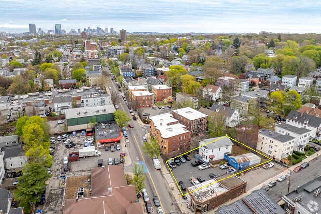
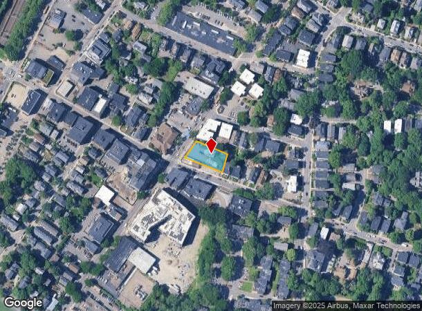
3326 Washington St, Jamaica Plain, MA 02130
NEARBY LISTINGS FOR SALE OR LEASE
Property Detail
3326 Washington St
JAMA-000000-000011-002341
Mass Wholesale Fd Whs
Storebuilding
Suffolk
X
Massachusetts
25025C0086G
0.28 AC
2025
Roxbury/Dorchester
2025
Boston
120301
Boston-Cambridge-Newton, MA-NH
3,404 SF
DEMOGRAPHICS near 3326 Washington St
1 Mile
3 Mile
5 Mile
2024 Total Population
39,404
404,700
819,179
2029 Population
37,077
386,272
789,257
Pop Growth 2024-2029
(5.91%)
(4.55%)
(3.65%)
Average Age
38
37
38
2024 Total Households
16,428
156,646
337,992
HH Growth 2024-2029
(6.62%)
(4.97%)
(3.93%)
Median Household Inc
$83,703
$72,482
$92,635
Avg Household Size
2.30
2.30
2.20
2024 Avg HH Vehicles
1.00
1.00
1.00
Median Home Value
$719,470
$750,391
$786,258
Median Year Built
1948
1948
1950
Nearby Places
Map Layers
Map Styles
 Street
 Aerial
- Restaurants
- Banks
- Shops
- Fitness
- Groceries
PUBLIC TRANSPORTATION
TRANSIT/SUBWAY
Green Street Station (Orange Line - Massachusetts Bay Transportation Authority Subway (The T))
DRIVE
WALK
Distance
Green Street Station (Orange Line - Massachusetts Bay Transportation Authority Subway (The T))
0 min
3 min
0.2 mi
Stony Brook Station (Orange Line - Massachusetts Bay Transportation Authority Subway (The T))
DRIVE
WALK
Distance
Stony Brook Station (Orange Line - Massachusetts Bay Transportation Authority Subway (The T))
1 min
12 min
0.6 mi
Forest Hills Station (Orange Line - Massachusetts Bay Transportation Authority Subway (The T))
DRIVE
WALK
Distance
Forest Hills Station (Orange Line - Massachusetts Bay Transportation Authority Subway (The T))
2 min
16 min
0.8 mi
COMMUTER RAIL
Forest Hills (Needham Line - Massachusetts Bay Transportation Authority Commuter Rail (Purple Line))
DRIVE
WALK
Distance
Forest Hills (Needham Line - Massachusetts Bay Transportation Authority Commuter Rail (Purple Line))
2 min
16 min
0.8 mi
Four Corners/Geneva (Fairmount Line - MBTA, Franklin/Foxboro Line - MBTA)
DRIVE
WALK
Distance
Four Corners/Geneva (Fairmount Line - MBTA, Franklin/Foxboro Line - MBTA)
6 min
2.3 mi
AIRPORT
General Edward Lawrence Logan International
DRIVE
WALK
Distance
General Edward Lawrence Logan International
15 min
7.5 mi
Freight Ports
Port of Boston
DRIVE
WALK
Distance
Port of Boston
13 min
5.8 mi
SALE & LEASE HISTORY
LISTING DATE
SALE/LEASE

May 07, 2024
For Sale
Nearby Properties
Address
Land Use
TOTAL SIZE
Lot Size
Zoning
Address
Land Use
TOTAL SIZE
Lot Size
Zoning
909,764 SF
25.13 AC
E
Address
Land Use
TOTAL SIZE
Lot Size
Zoning
610,560 SF
4.01 AC
E
Address
Land Use
TOTAL SIZE
Lot Size
Zoning
596,972 SF
7.32 AC
E
Address
Land Use
TOTAL SIZE
Lot Size
Zoning
118,759 SF
0.92 AC
C
Address
Land Use
TOTAL SIZE
Lot Size
Zoning
377,634 SF
4.86 AC
E
Address
Land Use
TOTAL SIZE
Lot Size
Zoning
227,107 SF
7.70 AC
E
Address
Land Use
TOTAL SIZE
Lot Size
Zoning
254,208 SF
3.83 AC
E
Address
Land Use
TOTAL SIZE
Lot Size
Zoning
262,120 SF
0.62 AC
C
Address
Land Use
TOTAL SIZE
Lot Size
Zoning
547,851 SF
8.14 AC
E
Address
Land Use
TOTAL SIZE
Lot Size
Zoning
305,455 SF
0.54 AC
RC
Address
Land Use
TOTAL SIZE
Lot Size
Zoning
303,055 SF
2.15 AC
RC
Address
Land Use
TOTAL SIZE
Lot Size
Zoning
269,232 SF
0.46 AC
C
Address
Land Use
TOTAL SIZE
Lot Size
Zoning
468,308 SF
0.78 AC
E
Address
Land Use
TOTAL SIZE
Lot Size
Zoning
443,356 SF
2.40 AC
C
Address
Land Use
TOTAL SIZE
Lot Size
Zoning
249,135 SF
1.99 AC
RC
Address
Land Use
TOTAL SIZE
Lot Size
Zoning
191,648 SF
0.65 AC
RC
Address
Land Use
TOTAL SIZE
Lot Size
Zoning
522,465 SF
5.34 AC
E
Address
Land Use
TOTAL SIZE
Lot Size
Zoning
76,658 SF
0.38 AC
E
Address
Land Use
TOTAL SIZE
Lot Size
Zoning
172,000 SF
0.31 AC
A
Address
Land Use
TOTAL SIZE
Lot Size
Zoning
208,468 SF
1.44 AC
RC
Address
Land Use
TOTAL SIZE
Lot Size
Zoning
268,675 SF
1.72 AC
I
Address
Land Use
TOTAL SIZE
Lot Size
Zoning
341,572 SF
1.71 AC
A
Address
Land Use
TOTAL SIZE
Lot Size
Zoning
147,997 SF
2.03 AC
GMR2
Address
Land Use
TOTAL SIZE
Lot Size
Zoning
225,241 SF
2.02 AC
E
Address
Land Use
TOTAL SIZE
Lot Size
Zoning
0.20 AC
E
Address
Land Use
TOTAL SIZE
Lot Size
Zoning
285,456 SF
1.43 AC
E
Address
Land Use
TOTAL SIZE
Lot Size
Zoning
432,703 SF
10.46 AC
E
Address
Land Use
TOTAL SIZE
Lot Size
Zoning
315,912 SF
1.08 AC
E
Address
Land Use
TOTAL SIZE
Lot Size
Zoning
146,751 SF
3.39 AC
E
Address
Land Use
TOTAL SIZE
Lot Size
Zoning
317,049 SF
11.22 AC
M05
The World's #1 Commercial Real Estate Marketplace
Connect with us
© 2025 CoStar Group
The information above has been obtained from sources believed reliable. While we do not doubt its accuracy we have not verified it and make no guarantee, warranty or representation about it. It is your responsibility to independently confirm its accuracy and completeness. Any projections, opinions, assumptions, or estimates used are for example only and do not represent the current or future performance of the property. The value of this transaction to you depends on tax and other factors which should be evaluated by your tax, financial, and legal advisors. You and your advisors should conduct a careful, independent investigation of the property to determine to your satisfaction the suitability of the property for your needs.