Property Record
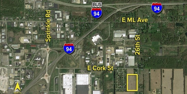
3328 S 26Th St, Kalamazoo, MI 49048
NEARBY LISTINGS FOR SALE OR LEASE
Property Detail
3328 S 26Th St
Kalamazoo-Portage, MI
SEC 31-2-10 BEG ON E LI 330.31 FT S 00DEG-39?-27? W OF NE COR TH CONT S 00DEG-39?-27? W 264.11 FT TH N 89DEG-15?-56? W 659.82
07-31-234-021
Kalamazoo
Agriculturalland
Michigan
2024
4 AC
2025
Southern Kalamazoo County
002204
West Michigan
DEMOGRAPHICS near 3328 S 26Th St
1 Mile
3 Mile
5 Mile
2024 Total Population
383
20,176
78,127
2029 Population
379
20,086
78,072
Pop Growth 2024-2029
(1.04%)
(0.45%)
(0.07%)
Average Age
43
37
37
2024 Total Households
148
8,237
33,325
HH Growth 2024-2029
(0.68%)
(0.55%)
(0.08%)
Median Household Inc
$66,111
$53,325
$51,367
Avg Household Size
2.40
2.40
2.20
2024 Avg HH Vehicles
2.00
2.00
2.00
Median Home Value
$223,256
$128,734
$149,685
Median Year Built
1966
1957
1958
Nearby Places
Map Layers
Map Styles
 Street
 Aerial
- Restaurants
- Banks
- Shops
- Fitness
- Groceries
PUBLIC TRANSPORTATION
AIRPORT
Kalamazoo/Battle Creek International
DRIVE
WALK
Distance
Kalamazoo/Battle Creek International
8 min
4.8 mi
Freight Ports
Port of Baltimore
DRIVE
WALK
Distance
Port of Baltimore
1 min
510.1 mi
SALE & LEASE HISTORY
LISTING DATE
SALE/LEASE

Sep 24, 2016
For Sale
May 02, 2019
For Sale
Jul 27, 2021
For Sale
Nearby Properties
Address
Land Use
TOTAL SIZE
Lot Size
Zoning
Address
Land Use
TOTAL SIZE
Lot Size
Zoning
82,520 SF
39.35 AC
I-1
Address
Land Use
TOTAL SIZE
Lot Size
Zoning
33.60 AC
Address
Land Use
TOTAL SIZE
Lot Size
Zoning
61.61 AC
Address
Land Use
TOTAL SIZE
Lot Size
Zoning
134,876 SF
16.45 AC
RM-15
Address
Land Use
TOTAL SIZE
Lot Size
Zoning
17,858 SF
15.27 AC
RM-1
Address
Land Use
TOTAL SIZE
Lot Size
Zoning
498,424 SF
41.72 AC
M-2
Address
Land Use
TOTAL SIZE
Lot Size
Zoning
298,908 SF
40.33 AC
Address
Land Use
TOTAL SIZE
Lot Size
Zoning
606,439 SF
34.61 AC
M-2
Address
Land Use
TOTAL SIZE
Lot Size
Zoning
Address
Land Use
TOTAL SIZE
Lot Size
Zoning
291,184 SF
26.35 AC
I-1
Address
Land Use
TOTAL SIZE
Lot Size
Zoning
80,064 SF
6.13 AC
M-1
Address
Land Use
TOTAL SIZE
Lot Size
Zoning
157,123 SF
M
Address
Land Use
TOTAL SIZE
Lot Size
Zoning
793,429 SF
36.48 AC
M
Address
Land Use
TOTAL SIZE
Lot Size
Zoning
393,522 SF
33.31 AC
M-2
Address
Land Use
TOTAL SIZE
Lot Size
Zoning
129,350 SF
42.30 AC
I-1
Address
Land Use
TOTAL SIZE
Lot Size
Zoning
104,366 SF
9.76 AC
B-3
Address
Land Use
TOTAL SIZE
Lot Size
Zoning
10.04 AC
I-1
Address
Land Use
TOTAL SIZE
Lot Size
Zoning
Address
Land Use
TOTAL SIZE
Lot Size
Zoning
79,947 SF
12.13 AC
M
Address
Land Use
TOTAL SIZE
Lot Size
Zoning
69,987 SF
8.58 AC
RM-15
Address
Land Use
TOTAL SIZE
Lot Size
Zoning
2,286 SF
74.31 AC
Address
Land Use
TOTAL SIZE
Lot Size
Zoning
105,000 SF
10.04 AC
I-1
Address
Land Use
TOTAL SIZE
Lot Size
Zoning
142,107 SF
14.97 AC
M-1
Address
Land Use
TOTAL SIZE
Lot Size
Zoning
10.76 AC
N/A
Address
Land Use
TOTAL SIZE
Lot Size
Zoning
478,944 SF
18.41 AC
M
Address
Land Use
TOTAL SIZE
Lot Size
Zoning
313,777 SF
15.30 AC
M-2
Address
Land Use
TOTAL SIZE
Lot Size
Zoning
80,640 SF
14.04 AC
Address
Land Use
TOTAL SIZE
Lot Size
Zoning
50,000 SF
17.50 AC
I-1
Address
Land Use
TOTAL SIZE
Lot Size
Zoning
30.40 AC
Address
Land Use
TOTAL SIZE
Lot Size
Zoning
The World's #1 Commercial Real Estate Marketplace
Connect with us
© 2025 CoStar Group
The information above has been obtained from sources believed reliable. While we do not doubt its accuracy we have not verified it and make no guarantee, warranty or representation about it. It is your responsibility to independently confirm its accuracy and completeness. Any projections, opinions, assumptions, or estimates used are for example only and do not represent the current or future performance of the property. The value of this transaction to you depends on tax and other factors which should be evaluated by your tax, financial, and legal advisors. You and your advisors should conduct a careful, independent investigation of the property to determine to your satisfaction the suitability of the property for your needs.