Property Record
333 3Rd St, Baton Rouge, LA 70801
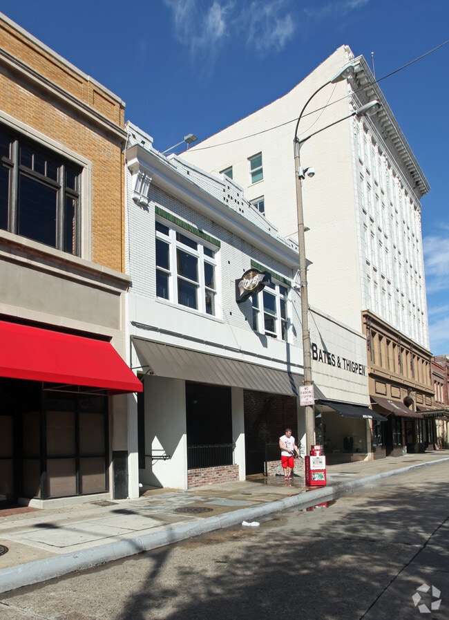


Property Detail
333 3Rd St
Baton Rouge, LA
WARD: 1-1, SUBDIVISION: DEVALL TOWN, LOT: 9-B, BLOCK: 3. LOT 9-B, SQ. 3, DEVALL TOWN(RESTAURANT)
00012602
E BATON ROUGE
Storesoffices
Louisiana
B and X Area of moderate flood hazard, usually the area between the limits of the 100-year and 500-year floods.
9-b
2025
0.09 AC
2025
North CBD
005100
Baton Rouge
7,350 SF
NEARBY LISTINGS FOR SALE OR LEASE
-
-
-
-
-
-
-
No Photo
-
View all Baton Rouge listings for sale on LoopNet.com
DEMOGRAPHICS near 333 3Rd St
1 mile
3 mile
5 mile
2025 Total Population
4,669
57,207
144,979
2030 Population
4,778
58,259
146,593
Pop Growth 2025-2030
+ 2.33%
+ 1.84%
+ 1.11%
Average Age
39
37
36
2025 Total Households
2,516
22,969
59,767
HH Growth 2025-2030
+ 1.91%
+ 2.05%
+ 1.22%
Median Household Inc
$46,998
$39,085
$40,478
Avg Household Size
1.70
2.10
2.20
2025 Avg HH Vehicles
1.00
1.00
1.00
Median Home Value
$221,925
$190,144
$221,435
Median Year Built
1962
1962
1973
Nearby Places
Map Layers
Map Styles
 Street
 Aerial
Transit
 Traffic
 Biking
Places
Listings with unknown addresses are not visible on the map
- Restaurants
- Banks
- Shops
- Fitness
- Groceries
PUBLIC TRANSPORTATION
AIRPORT
Baton Rouge Metro Ryan Field
Drive
Walk
Distance
Baton Rouge Metro Ryan Field
14 min
8.2 mi
Freight Ports
Port of Greater Baton Rouge
Drive
Walk
Distance
Port of Greater Baton Rouge
10 min
3.9 mi
SALE & LEASE HISTORY
LISTING DATE
SALE/LEASE

Feb 23, 2019
For Sale
Nearby Properties
Address
Land Use
TOTAL SIZE
Lot Size
Zoning
Address
Land Use
TOTAL SIZE
Lot Size
Zoning
Address
Land Use
TOTAL SIZE
Lot Size
Zoning
Address
Land Use
TOTAL SIZE
Lot Size
Zoning
Address
Land Use
TOTAL SIZE
Lot Size
Zoning
332,000 SF
1.42 AC
Address
Land Use
TOTAL SIZE
Lot Size
Zoning
290,620 SF
1.76 AC
Address
Land Use
TOTAL SIZE
Lot Size
Zoning
Address
Land Use
TOTAL SIZE
Lot Size
Zoning
8.83 AC
Address
Land Use
TOTAL SIZE
Lot Size
Zoning
153 AC
Address
Land Use
TOTAL SIZE
Lot Size
Zoning
50,025 SF
6.68 AC
Address
Land Use
TOTAL SIZE
Lot Size
Zoning
25,369 SF
1,200 AC
Address
Land Use
TOTAL SIZE
Lot Size
Zoning
385,397 SF
509.42 AC
Address
Land Use
TOTAL SIZE
Lot Size
Zoning
681,854 SF
4.50 AC
Address
Land Use
TOTAL SIZE
Lot Size
Zoning
55,755 SF
9.29 AC
Address
Land Use
TOTAL SIZE
Lot Size
Zoning
244,833 SF
0.84 AC
Address
Land Use
TOTAL SIZE
Lot Size
Zoning
76,498 SF
10.93 AC
Address
Land Use
TOTAL SIZE
Lot Size
Zoning
17.51 AC
Address
Land Use
TOTAL SIZE
Lot Size
Zoning
350,000 SF
1.20 AC
Address
Land Use
TOTAL SIZE
Lot Size
Zoning
521,303 SF
16.24 AC
Address
Land Use
TOTAL SIZE
Lot Size
Zoning
100,000 SF
Address
Land Use
TOTAL SIZE
Lot Size
Zoning
Address
Land Use
TOTAL SIZE
Lot Size
Zoning
207,577 SF
0.93 AC
Address
Land Use
TOTAL SIZE
Lot Size
Zoning
Address
Land Use
TOTAL SIZE
Lot Size
Zoning
23,809 SF
5.28 AC
Address
Land Use
TOTAL SIZE
Lot Size
Zoning
2,074 SF
18.72 AC
Address
Land Use
TOTAL SIZE
Lot Size
Zoning
149,372 SF
0.19 AC
Address
Land Use
TOTAL SIZE
Lot Size
Zoning
15.49 AC
Address
Land Use
TOTAL SIZE
Lot Size
Zoning
166,222 SF
1.06 AC
Address
Land Use
TOTAL SIZE
Lot Size
Zoning
0.19 AC
Address
Land Use
TOTAL SIZE
Lot Size
Zoning
336,660 SF
Address
Land Use
TOTAL SIZE
Lot Size
Zoning
The World's #1 Commercial Real Estate Marketplace
Connect with us
© 2026 CoStar Group
The information above has been obtained from sources believed reliable. While we do not doubt its accuracy we have not verified it and make no guarantee, warranty or representation about it. It is your responsibility to independently confirm its accuracy and completeness. Any projections, opinions, assumptions, or estimates used are for example only and do not represent the current or future performance of the property. The value of this transaction to you depends on tax and other factors which should be evaluated by your tax, financial, and legal advisors. You and your advisors should conduct a careful, independent investigation of the property to determine to your satisfaction the suitability of the property for your needs.