Property Record
333 Bonnie Brae Dr, Spartanburg, SC 29303
NEARBY LISTINGS FOR SALE OR LEASE
Property Detail
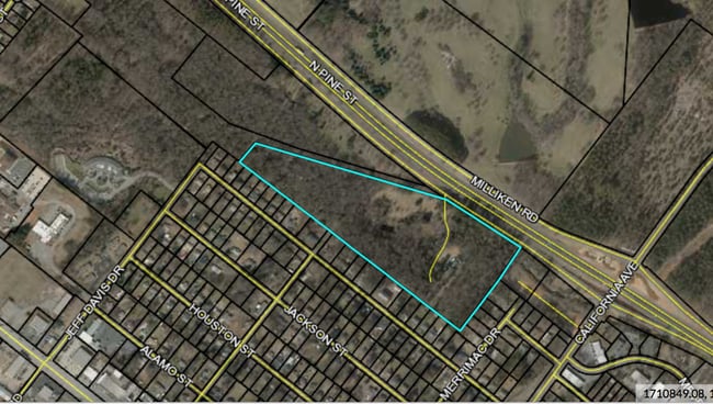
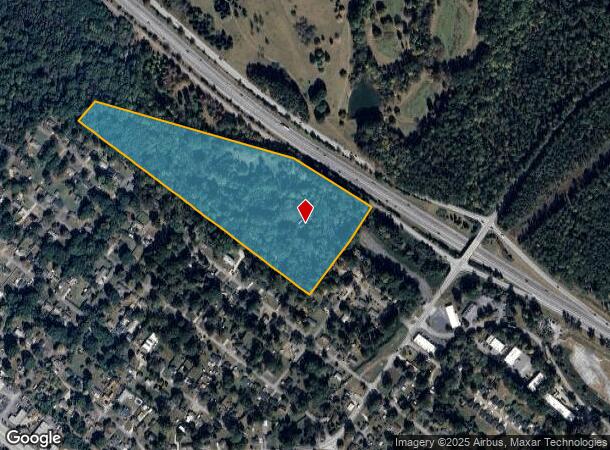
333 Bonnie Brae Dr
6-13-08-001.00
S SIDE I 585 W OF MERRIMAC ST PB 14-31
Taxexempt
Spartanburg
X
South Carolina
45083C0252D
20.70 AC
2024
North Side/Rt 9 Corridor
2025
Greenville/Spartanburg
021600
Spartanburg, SC
3,168 SF
DEMOGRAPHICS near 333 Bonnie Brae Dr
1 Mile
3 Mile
5 Mile
2024 Total Population
4,745
44,781
108,427
2029 Population
5,382
50,853
122,815
Pop Growth 2024-2029
+ 13.42%
+ 13.56%
+ 13.27%
Average Age
40
36
38
2024 Total Households
1,732
16,606
42,664
HH Growth 2024-2029
+ 13.97%
+ 14.42%
+ 13.74%
Median Household Inc
$38,026
$39,298
$48,278
Avg Household Size
2.40
2.30
2.40
2024 Avg HH Vehicles
2.00
2.00
2.00
Median Home Value
$125,545
$129,808
$162,948
Median Year Built
1974
1978
1979
Nearby Places
Map Layers
Map Styles
 Street
 Aerial
- Restaurants
- Banks
- Shops
- Fitness
- Groceries
PUBLIC TRANSPORTATION
COMMUTER RAIL
Spartanburg Amtrak Station (Crescent - Amtrak)
DRIVE
WALK
Distance
Spartanburg Amtrak Station (Crescent - Amtrak)
6 min
2.4 mi
AIRPORT
Greenville Spartanburg International
DRIVE
WALK
Distance
Greenville Spartanburg International
30 min
20.3 mi
Freight Ports
North Charleston Terminal
DRIVE
WALK
Distance
North Charleston Terminal
225 min
199.6 mi
SALE & LEASE HISTORY
LISTING DATE
SALE/LEASE

Nov 12, 2020
For Sale
Nearby Properties
Address
Land Use
TOTAL SIZE
Lot Size
Zoning
Address
Land Use
TOTAL SIZE
Lot Size
Zoning
5,130 SF
19.69 AC
Address
Land Use
TOTAL SIZE
Lot Size
Zoning
2,134 SF
27.72 AC
Address
Land Use
TOTAL SIZE
Lot Size
Zoning
9,312 SF
9.06 AC
Address
Land Use
TOTAL SIZE
Lot Size
Zoning
5,672 SF
10.20 AC
Address
Land Use
TOTAL SIZE
Lot Size
Zoning
27,491 SF
2.95 AC
Address
Land Use
TOTAL SIZE
Lot Size
Zoning
5,547 SF
6.58 AC
Address
Land Use
TOTAL SIZE
Lot Size
Zoning
141,112 SF
3.38 AC
Address
Land Use
TOTAL SIZE
Lot Size
Zoning
15,108 SF
16.27 AC
Address
Land Use
TOTAL SIZE
Lot Size
Zoning
2,100 SF
10.12 AC
Address
Land Use
TOTAL SIZE
Lot Size
Zoning
19,876 SF
0.03 AC
Address
Land Use
TOTAL SIZE
Lot Size
Zoning
3,171 SF
21.41 AC
Address
Land Use
TOTAL SIZE
Lot Size
Zoning
12,740 SF
1.48 AC
Address
Land Use
TOTAL SIZE
Lot Size
Zoning
13,160 SF
1.62 AC
Address
Land Use
TOTAL SIZE
Lot Size
Zoning
106,100 SF
24.56 AC
Address
Land Use
TOTAL SIZE
Lot Size
Zoning
6,517 SF
6.68 AC
Address
Land Use
TOTAL SIZE
Lot Size
Zoning
12,069 SF
0.03 AC
Address
Land Use
TOTAL SIZE
Lot Size
Zoning
44,301 SF
7.47 AC
Address
Land Use
TOTAL SIZE
Lot Size
Zoning
40,995 SF
0.74 AC
Address
Land Use
TOTAL SIZE
Lot Size
Zoning
31,913 SF
1.03 AC
Address
Land Use
TOTAL SIZE
Lot Size
Zoning
31,054 SF
0.48 AC
Address
Land Use
TOTAL SIZE
Lot Size
Zoning
122,626 SF
7.70 AC
Address
Land Use
TOTAL SIZE
Lot Size
Zoning
8,872 SF
0.03 AC
Address
Land Use
TOTAL SIZE
Lot Size
Zoning
2,022 SF
3.50 AC
Address
Land Use
TOTAL SIZE
Lot Size
Zoning
6,110 SF
6.01 AC
Address
Land Use
TOTAL SIZE
Lot Size
Zoning
6,798 SF
31.44 AC
Address
Land Use
TOTAL SIZE
Lot Size
Zoning
83,698 SF
18.14 AC
Address
Land Use
TOTAL SIZE
Lot Size
Zoning
81,040 SF
15.39 AC
Address
Land Use
TOTAL SIZE
Lot Size
Zoning
89,435 SF
5.33 AC
Address
Land Use
TOTAL SIZE
Lot Size
Zoning
101,622 SF
19.63 AC
Address
Land Use
TOTAL SIZE
Lot Size
Zoning
20,976 SF
23.72 AC
The World's #1 Commercial Real Estate Marketplace
Connect with us
© 2025 CoStar Group
The information above has been obtained from sources believed reliable. While we do not doubt its accuracy we have not verified it and make no guarantee, warranty or representation about it. It is your responsibility to independently confirm its accuracy and completeness. Any projections, opinions, assumptions, or estimates used are for example only and do not represent the current or future performance of the property. The value of this transaction to you depends on tax and other factors which should be evaluated by your tax, financial, and legal advisors. You and your advisors should conduct a careful, independent investigation of the property to determine to your satisfaction the suitability of the property for your needs.