Property Record
333 E Mill Pond Rd, Lehi, UT 84043
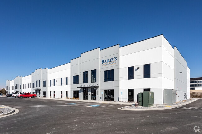

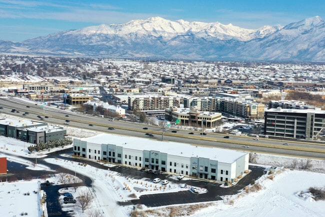
Property Detail
333 E Mill Pond Rd
Provo-Orem-Lehi, UT
LOT 1, NEW STAR COMMERCIAL DEVELOPMENT SUB AREA 2.998 AC.
47-368-0001
UTAH
Industrialgeneral
Utah
2024
1
2025
3 AC
000103
Utah County
42,205 SF
Salt Lake City
NEARBY LISTINGS FOR SALE OR LEASE
DEMOGRAPHICS near 333 E Mill Pond Rd
1 mile
3 mile
5 mile
2025 Total Population
9,124
83,554
192,237
2030 Population
10,209
92,002
213,089
Pop Growth 2025-2030
+ 11.89%
+ 10.11%
+ 10.85%
Average Age
33
32
32
2025 Total Households
2,771
23,148
53,917
HH Growth 2025-2030
+ 12.99%
+ 11.03%
+ 11.62%
Median Household Inc
$98,593
$120,281
$122,869
Avg Household Size
3.20
3.60
3.60
2025 Avg HH Vehicles
2.00
3.00
2.00
Median Home Value
$634,835
$647,809
$665,935
Median Year Built
2003
2001
2007
Nearby Places
Map Layers
Map Styles
 Street
 Aerial
Layers
 Traffic
 Biking
Places
Listings with unknown addresses are not visible on the map
- Restaurants
- Banks
- Shops
- Fitness
- Groceries
PUBLIC TRANSPORTATION
AIRPORT
Salt Lake City International
Drive
Walk
Distance
Salt Lake City International
42 min
33.9 mi
Freight Ports
Port of Long Beach
Drive
Walk
Distance
Port of Long Beach
708 min
673.2 mi
SALE & LEASE HISTORY
LISTING DATE
SALE/LEASE

Oct 05, 2020
For Lease
Nov 26, 2024
For Lease
Nov 06, 2023
For Lease
Nearby Properties
Address
Land Use
TOTAL SIZE
Lot Size
Zoning
Address
Land Use
TOTAL SIZE
Lot Size
Zoning
359,445 SF
6.46 AC
Address
Land Use
TOTAL SIZE
Lot Size
Zoning
305,553 SF
13.08 AC
Address
Land Use
TOTAL SIZE
Lot Size
Zoning
181,908 SF
1.43 AC
Address
Land Use
TOTAL SIZE
Lot Size
Zoning
227,030 SF
21.91 AC
Address
Land Use
TOTAL SIZE
Lot Size
Zoning
201,838 SF
8.83 AC
Address
Land Use
TOTAL SIZE
Lot Size
Zoning
153,790 SF
12.07 AC
Address
Land Use
TOTAL SIZE
Lot Size
Zoning
200,016 SF
8.82 AC
Address
Land Use
TOTAL SIZE
Lot Size
Zoning
122,777 SF
6.68 AC
Address
Land Use
TOTAL SIZE
Lot Size
Zoning
149,937 SF
13.49 AC
Address
Land Use
TOTAL SIZE
Lot Size
Zoning
143,438 SF
7.43 AC
Address
Land Use
TOTAL SIZE
Lot Size
Zoning
100,814 SF
8.22 AC
Address
Land Use
TOTAL SIZE
Lot Size
Zoning
62,104 SF
8.97 AC
Address
Land Use
TOTAL SIZE
Lot Size
Zoning
110,561 SF
6.47 AC
Address
Land Use
TOTAL SIZE
Lot Size
Zoning
1,121 SF
4.07 AC
Address
Land Use
TOTAL SIZE
Lot Size
Zoning
137,193 SF
12.45 AC
Address
Land Use
TOTAL SIZE
Lot Size
Zoning
111,292 SF
5.36 AC
Address
Land Use
TOTAL SIZE
Lot Size
Zoning
100,973 SF
5.71 AC
Address
Land Use
TOTAL SIZE
Lot Size
Zoning
120,431 SF
7.92 AC
Address
Land Use
TOTAL SIZE
Lot Size
Zoning
76,420 SF
3.94 AC
Address
Land Use
TOTAL SIZE
Lot Size
Zoning
91,812 SF
6.99 AC
Address
Land Use
TOTAL SIZE
Lot Size
Zoning
124,836 SF
8.74 AC
Address
Land Use
TOTAL SIZE
Lot Size
Zoning
114,574 SF
6.78 AC
Address
Land Use
TOTAL SIZE
Lot Size
Zoning
65,449 SF
2.27 AC
Address
Land Use
TOTAL SIZE
Lot Size
Zoning
157,950 SF
6.53 AC
Address
Land Use
TOTAL SIZE
Lot Size
Zoning
96,361 SF
7.86 AC
Address
Land Use
TOTAL SIZE
Lot Size
Zoning
107,722 SF
5.65 AC
Address
Land Use
TOTAL SIZE
Lot Size
Zoning
105,188 SF
10.64 AC
Address
Land Use
TOTAL SIZE
Lot Size
Zoning
97,088 SF
3.88 AC
Address
Land Use
TOTAL SIZE
Lot Size
Zoning
95,683 SF
9.32 AC
Address
Land Use
TOTAL SIZE
Lot Size
Zoning
58,277 SF
7.49 AC
The World's #1 Commercial Real Estate Marketplace
Connect with us
© 2026 CoStar Group
The information above has been obtained from sources believed reliable. While we do not doubt its accuracy we have not verified it and make no guarantee, warranty or representation about it. It is your responsibility to independently confirm its accuracy and completeness. Any projections, opinions, assumptions, or estimates used are for example only and do not represent the current or future performance of the property. The value of this transaction to you depends on tax and other factors which should be evaluated by your tax, financial, and legal advisors. You and your advisors should conduct a careful, independent investigation of the property to determine to your satisfaction the suitability of the property for your needs.