Property Record
333 Kent Rd, Kent, CT 06757
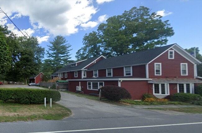

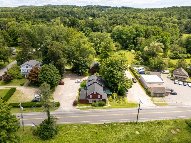
Property Detail
333 Kent Rd
Torrington, CT
Nw Hills
KENT-000006-000011-000005
Connecticut
Commercialbuilding
5
2025
5.42 AC
2025
New Milford/SW Litchfield
266100
Hartford
5,198 SF
NEARBY LISTINGS FOR SALE OR LEASE
-
-
View all Kent listings for sale on LoopNet.com
DEMOGRAPHICS near 333 Kent Rd
1 mile
3 mile
5 mile
2025 Total Population
243
4,724
11,093
2030 Population
254
4,849
11,413
Pop Growth 2025-2030
+ 4.53%
+ 2.65%
+ 2.88%
Average Age
44
44
44
2025 Total Households
93
1,772
4,257
HH Growth 2025-2030
+ 5.38%
+ 2.82%
+ 3.08%
Median Household Inc
$94,444
$131,349
$120,603
Avg Household Size
2.20
2.60
2.50
2025 Avg HH Vehicles
2.00
2.00
2.00
Median Home Value
$394,117
$425,811
$438,335
Median Year Built
1988
1983
1977
Nearby Places
Map Layers
Map Styles
 Street
 Aerial
Transit
 Traffic
 Biking
Places
Listings with unknown addresses are not visible on the map
- Restaurants
- Banks
- Shops
- Fitness
- Groceries
PUBLIC TRANSPORTATION
COMMUTER RAIL
Harlem Valley-Wingdale Station (Harlem Line - Metro-North Commuter Railroad Company (Metro-North))
Drive
Walk
Distance
Harlem Valley-Wingdale Station (Harlem Line - Metro-North Commuter Railroad Company (Metro-North))
11 min
5.3 mi
Freight Ports
Port of New Haven
Drive
Walk
Distance
Port of New Haven
80 min
51.9 mi
SALE & LEASE HISTORY
LISTING DATE
SALE/LEASE

Jul 21, 2025
For Sale
Apr 19, 2023
For Sale
Nearby Properties
Address
Land Use
TOTAL SIZE
Lot Size
Zoning
Address
Land Use
TOTAL SIZE
Lot Size
Zoning
Address
Land Use
TOTAL SIZE
Lot Size
Zoning
45,538 SF
294.20 AC
RU Y
Address
Land Use
TOTAL SIZE
Lot Size
Zoning
26,696 SF
196.53 AC
RU Y
Address
Land Use
TOTAL SIZE
Lot Size
Zoning
2,709 SF
172.34 AC
R80
Address
Land Use
TOTAL SIZE
Lot Size
Zoning
7,924 SF
8.55 AC
R80
Address
Land Use
TOTAL SIZE
Lot Size
Zoning
121,016 SF
24.95 AC
CO
Address
Land Use
TOTAL SIZE
Lot Size
Zoning
2,214 SF
148.12 AC
Address
Land Use
TOTAL SIZE
Lot Size
Zoning
100.09 AC
Address
Land Use
TOTAL SIZE
Lot Size
Zoning
25.06 AC
Address
Land Use
TOTAL SIZE
Lot Size
Zoning
6,470 SF
7.70 AC
Address
Land Use
TOTAL SIZE
Lot Size
Zoning
12,800 SF
35.01 AC
Address
Land Use
TOTAL SIZE
Lot Size
Zoning
143 AC
Address
Land Use
TOTAL SIZE
Lot Size
Zoning
Address
Land Use
TOTAL SIZE
Lot Size
Zoning
Address
Land Use
TOTAL SIZE
Lot Size
Zoning
194.40 AC
RU
Address
Land Use
TOTAL SIZE
Lot Size
Zoning
10.02 AC
Address
Land Use
TOTAL SIZE
Lot Size
Zoning
267.17 AC
Address
Land Use
TOTAL SIZE
Lot Size
Zoning
3,024 SF
128.18 AC
R2
Address
Land Use
TOTAL SIZE
Lot Size
Zoning
168.50 AC
R80
Address
Land Use
TOTAL SIZE
Lot Size
Zoning
Address
Land Use
TOTAL SIZE
Lot Size
Zoning
14,721 SF
236.90 AC
RC Y
Address
Land Use
TOTAL SIZE
Lot Size
Zoning
1,763 SF
8.61 AC
Address
Land Use
TOTAL SIZE
Lot Size
Zoning
Address
Land Use
TOTAL SIZE
Lot Size
Zoning
8 AC
CO Y
Address
Land Use
TOTAL SIZE
Lot Size
Zoning
146 AC
Address
Land Use
TOTAL SIZE
Lot Size
Zoning
4,268 SF
4.30 AC
Address
Land Use
TOTAL SIZE
Lot Size
Zoning
1,522 SF
293.49 AC
Address
Land Use
TOTAL SIZE
Lot Size
Zoning
1,326 SF
12.10 AC
Address
Land Use
TOTAL SIZE
Lot Size
Zoning
3,188 SF
7.38 AC
Address
Land Use
TOTAL SIZE
Lot Size
Zoning
6,212 SF
100 AC
RU Y
The World's #1 Commercial Real Estate Marketplace
Connect with us
© 2026 CoStar Group
The information above has been obtained from sources believed reliable. While we do not doubt its accuracy we have not verified it and make no guarantee, warranty or representation about it. It is your responsibility to independently confirm its accuracy and completeness. Any projections, opinions, assumptions, or estimates used are for example only and do not represent the current or future performance of the property. The value of this transaction to you depends on tax and other factors which should be evaluated by your tax, financial, and legal advisors. You and your advisors should conduct a careful, independent investigation of the property to determine to your satisfaction the suitability of the property for your needs.