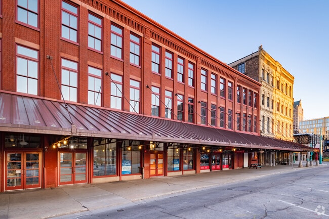
Property Record
333 N Broadway, Milwaukee, WI 53202

NEARBY LISTINGS FOR SALE OR LEASE
-
-
-
-
-
-
-
-
-
-
-
-
-
-
1801-1805 N Dr Martin Luther King Jr Dr
Milwaukee, WI 53212
$280,000 - $760,000
1,721 - 6,714 SF
Retail
-
-
-
-
View all Milwaukee listings for lease on LoopNet.com
Property Detail
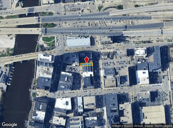
333 N Broadway
Milwaukee-Waukesha-West Allis, WI
Town Of Milwaukee
392-0996-000-5
PLAT OF MILWAUKEE IN SECS (28-29-33)-7-22 BLOCK 37 S 1/2 OF N 55 LOT 2 BID #02
Warehouse
Milwaukee
X
Wisconsin
55079C0091E
2
2024
0.08 AC
2024
Third Ward/Walkers Pt
187400
Milwaukee/Madison
8,496 SF
DEMOGRAPHICS near 333 N Broadway
1 Mile
3 Mile
5 Mile
2024 Total Population
19,025
197,088
411,762
2029 Population
18,973
194,091
404,653
Pop Growth 2024-2029
(0.27%)
(1.52%)
(1.73%)
Average Age
36
34
36
2024 Total Households
11,549
85,899
173,787
HH Growth 2024-2029
(0.19%)
(1.42%)
(1.74%)
Median Household Inc
$71,335
$42,022
$47,838
Avg Household Size
1.50
2.10
2.20
2024 Avg HH Vehicles
1.00
1.00
1.00
Median Home Value
$332,211
$178,805
$180,223
Median Year Built
1968
1948
1947
Nearby Places
Map Layers
Map Styles
 Street
 Aerial
- Restaurants
- Banks
- Shops
- Fitness
- Groceries
PUBLIC TRANSPORTATION
COMMUTER RAIL
DRIVE
WALK
Distance
3 min
10 min
0.5 mi
DRIVE
WALK
Distance
18 min
7.4 mi
AIRPORT
General Mitchell International
DRIVE
WALK
Distance
General Mitchell International
17 min
8.5 mi
SALE & LEASE HISTORY
LISTING DATE
SALE/LEASE

Oct 25, 2017
For Lease
Nov 18, 2016
For Lease
Nearby Properties
Address
Land Use
TOTAL SIZE
Lot Size
Zoning
Address
Land Use
TOTAL SIZE
Lot Size
Zoning
1,140,196 SF
5.33 AC
C9F(A)
Address
Land Use
TOTAL SIZE
Lot Size
Zoning
8.05 AC
TL
Address
Land Use
TOTAL SIZE
Lot Size
Zoning
730,000 SF
6.94 AC
PD
Address
Land Use
TOTAL SIZE
Lot Size
Zoning
237,850 SF
5.02 AC
RM7
Address
Land Use
TOTAL SIZE
Lot Size
Zoning
1,330,372 SF
2.48 AC
C9F(A)
Address
Land Use
TOTAL SIZE
Lot Size
Zoning
41.05 AC
IO2
Address
Land Use
TOTAL SIZE
Lot Size
Zoning
715,000 SF
2.71 AC
C9F(B)
Address
Land Use
TOTAL SIZE
Lot Size
Zoning
3.04 AC
TL
Address
Land Use
TOTAL SIZE
Lot Size
Zoning
523,726 SF
0.79 AC
C9B(B)
Address
Land Use
TOTAL SIZE
Lot Size
Zoning
607,577 SF
1.67 AC
PD
Address
Land Use
TOTAL SIZE
Lot Size
Zoning
370,160 SF
2.93 AC
C9F(A)
Address
Land Use
TOTAL SIZE
Lot Size
Zoning
380,817 SF
0.82 AC
C9F(A)
Address
Land Use
TOTAL SIZE
Lot Size
Zoning
362,007 SF
1.02 AC
C9F(A)
Address
Land Use
TOTAL SIZE
Lot Size
Zoning
495,212 SF
0.48 AC
C9F(A)
Address
Land Use
TOTAL SIZE
Lot Size
Zoning
414,410 SF
2.16 AC
C9F(A)
Address
Land Use
TOTAL SIZE
Lot Size
Zoning
280,000 SF
2.74 AC
RED
Address
Land Use
TOTAL SIZE
Lot Size
Zoning
417,704 SF
0.81 AC
PD
Address
Land Use
TOTAL SIZE
Lot Size
Zoning
173,610 SF
1.70 AC
IM
Address
Land Use
TOTAL SIZE
Lot Size
Zoning
378,717 SF
0.61 AC
C9D(A)
Address
Land Use
TOTAL SIZE
Lot Size
Zoning
535,904 SF
3.88 AC
C9A(A)
Address
Land Use
TOTAL SIZE
Lot Size
Zoning
491,759 SF
3 AC
C9F(A)
Address
Land Use
TOTAL SIZE
Lot Size
Zoning
272,475 SF
0.66 AC
PD
Address
Land Use
TOTAL SIZE
Lot Size
Zoning
319,559 SF
6.29 AC
PD
Address
Land Use
TOTAL SIZE
Lot Size
Zoning
300,416 SF
1.24 AC
PD
Address
Land Use
TOTAL SIZE
Lot Size
Zoning
4.53 AC
C9F(A)
Address
Land Use
TOTAL SIZE
Lot Size
Zoning
382,921 SF
2.81 AC
PD
Address
Land Use
TOTAL SIZE
Lot Size
Zoning
425,000 SF
1.42 AC
C9F(A)
Address
Land Use
TOTAL SIZE
Lot Size
Zoning
179 AC
IH
Address
Land Use
TOTAL SIZE
Lot Size
Zoning
180,407 SF
0.63 AC
PD
Address
Land Use
TOTAL SIZE
Lot Size
Zoning
534,786 SF
1.81 AC
C9D(A)
The World's #1 Commercial Real Estate Marketplace
Connect with us
© 2025 CoStar Group
The information above has been obtained from sources believed reliable. While we do not doubt its accuracy we have not verified it and make no guarantee, warranty or representation about it. It is your responsibility to independently confirm its accuracy and completeness. Any projections, opinions, assumptions, or estimates used are for example only and do not represent the current or future performance of the property. The value of this transaction to you depends on tax and other factors which should be evaluated by your tax, financial, and legal advisors. You and your advisors should conduct a careful, independent investigation of the property to determine to your satisfaction the suitability of the property for your needs.