Property Record
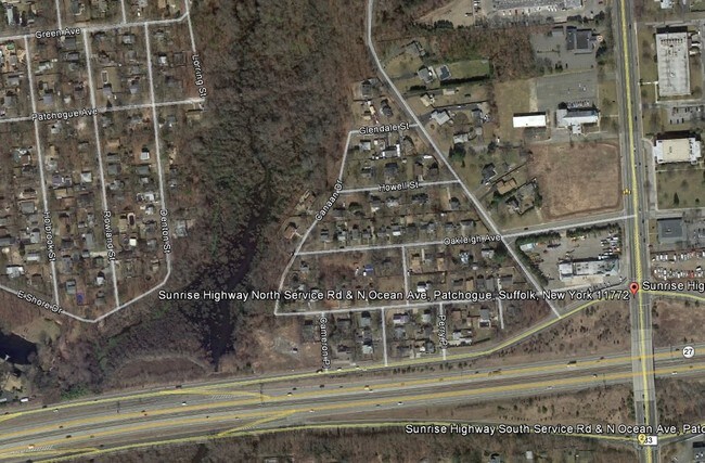
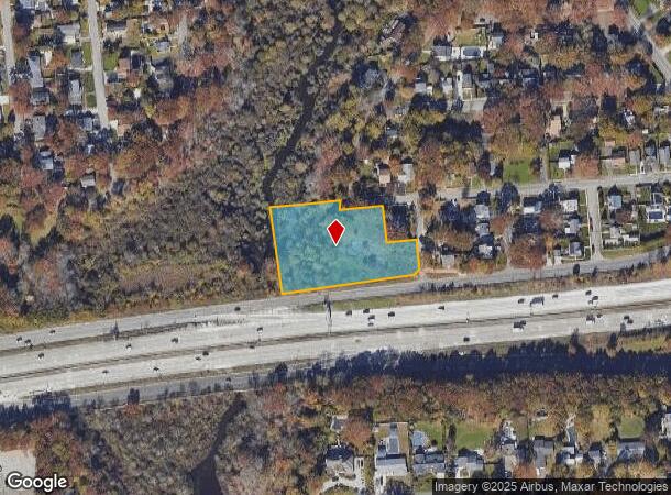
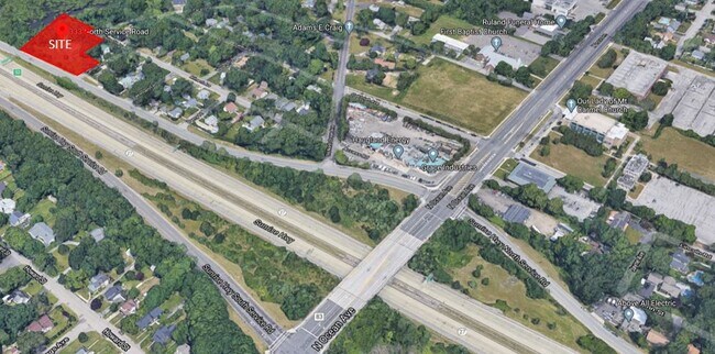
333 N Service Rd, Patchogue, NY 11772

This Property Is For Sale
NEARBY LISTINGS FOR SALE OR LEASE
-
-
-
-
No Photo
-
View all Patchogue listings for sale on LoopNet.com
Property Detail
333 N Service Rd
Nassau County-Suffolk County, NY
Patchogue (M To Z)
0200-973-10-02-00-036-000
N HIGH OF PATCH E CAMERON PLACE S S
Commercialacreage
Suffolk
A
New York
36103C0694H
36
2024
1.80 AC
2024
Central Suffolk
158806
Long Island (New York)
DEMOGRAPHICS near 333 N Service Rd
1 Mile
3 Mile
5 Mile
2024 Total Population
11,932
80,370
175,036
2029 Population
11,700
79,473
173,244
Pop Growth 2024-2029
(1.94%)
(1.12%)
(1.02%)
Average Age
41
42
42
2024 Total Households
4,675
30,168
61,574
HH Growth 2024-2029
(2.12%)
(1.29%)
(1.23%)
Median Household Inc
$100,322
$106,641
$110,880
Avg Household Size
2.50
2.60
2.70
2024 Avg HH Vehicles
2.00
2.00
2.00
Median Home Value
$387,574
$453,126
$450,018
Median Year Built
1966
1974
1973
Nearby Places
Map Layers
Map Styles
 Street
 Aerial
- Restaurants
- Banks
- Shops
- Fitness
- Groceries
PUBLIC TRANSPORTATION
COMMUTER RAIL
Patchogue Station (Montauk Branch - Long Island Rail Road)
DRIVE
WALK
Distance
Patchogue Station (Montauk Branch - Long Island Rail Road)
5 min
1.8 mi
Medford Station (Greenport Branch - Long Island Rail Road)
DRIVE
WALK
Distance
Medford Station (Greenport Branch - Long Island Rail Road)
7 min
3.4 mi
AIRPORT
Long Island MacArthur
DRIVE
WALK
Distance
Long Island MacArthur
11 min
5.3 mi
Freight Ports
Port of New Haven
DRIVE
WALK
Distance
Port of New Haven
131 min
50.4 mi
Nearby Properties
Address
Land Use
TOTAL SIZE
Lot Size
Zoning
Address
Land Use
TOTAL SIZE
Lot Size
Zoning
30.25 AC
CA
Address
Land Use
TOTAL SIZE
Lot Size
Zoning
33.47 AC
AA
Address
Land Use
TOTAL SIZE
Lot Size
Zoning
95.19 AC
Address
Land Use
TOTAL SIZE
Lot Size
Zoning
29.86 AC
CA
Address
Land Use
TOTAL SIZE
Lot Size
Zoning
26.28 AC
CA
Address
Land Use
TOTAL SIZE
Lot Size
Zoning
7,290 SF
15.71 AC
CA
Address
Land Use
TOTAL SIZE
Lot Size
Zoning
96 SF
18.29 AC
BUS3
Address
Land Use
TOTAL SIZE
Lot Size
Zoning
3,025 SF
5.60 AC
AA
Address
Land Use
TOTAL SIZE
Lot Size
Zoning
12.70 AC
IND1
Address
Land Use
TOTAL SIZE
Lot Size
Zoning
5.01 AC
AA278
Address
Land Use
TOTAL SIZE
Lot Size
Zoning
42.37 AC
Address
Land Use
TOTAL SIZE
Lot Size
Zoning
12.14 AC
BUS3
Address
Land Use
TOTAL SIZE
Lot Size
Zoning
14.73 AC
AA
Address
Land Use
TOTAL SIZE
Lot Size
Zoning
11.19 AC
Address
Land Use
TOTAL SIZE
Lot Size
Zoning
16.90 AC
AA
Address
Land Use
TOTAL SIZE
Lot Size
Zoning
19.70 AC
AA
Address
Land Use
TOTAL SIZE
Lot Size
Zoning
14.70 AC
BUS3
Address
Land Use
TOTAL SIZE
Lot Size
Zoning
17.52 AC
ICD
Address
Land Use
TOTAL SIZE
Lot Size
Zoning
9,148 SF
10.30 AC
CA
Address
Land Use
TOTAL SIZE
Lot Size
Zoning
14.75 AC
CA
Address
Land Use
TOTAL SIZE
Lot Size
Zoning
3,278 SF
0.51 AC
VILLA
Address
Land Use
TOTAL SIZE
Lot Size
Zoning
3,942 SF
0.45 AC
VILLA
Address
Land Use
TOTAL SIZE
Lot Size
Zoning
13.39 AC
C
Address
Land Use
TOTAL SIZE
Lot Size
Zoning
2,432 SF
21.76 AC
IND1
Address
Land Use
TOTAL SIZE
Lot Size
Zoning
12.32 AC
IND1
Address
Land Use
TOTAL SIZE
Lot Size
Zoning
4.23 AC
IND1
Address
Land Use
TOTAL SIZE
Lot Size
Zoning
11.14 AC
IND1
Address
Land Use
TOTAL SIZE
Lot Size
Zoning
8.10 AC
GSC
Address
Land Use
TOTAL SIZE
Lot Size
Zoning
3,960 SF
0.72 AC
R40
Address
Land Use
TOTAL SIZE
Lot Size
Zoning
8.60 AC
IND1
The World's #1 Commercial Real Estate Marketplace
Connect with us
© 2026 CoStar Group
The information above has been obtained from sources believed reliable. While we do not doubt its accuracy we have not verified it and make no guarantee, warranty or representation about it. It is your responsibility to independently confirm its accuracy and completeness. Any projections, opinions, assumptions, or estimates used are for example only and do not represent the current or future performance of the property. The value of this transaction to you depends on tax and other factors which should be evaluated by your tax, financial, and legal advisors. You and your advisors should conduct a careful, independent investigation of the property to determine to your satisfaction the suitability of the property for your needs.