Property Record
333 University Ave, Sacramento, CA 95825


Current Lease Availabilities
NEARBY LISTINGS FOR SALE OR LEASE
Property Detail
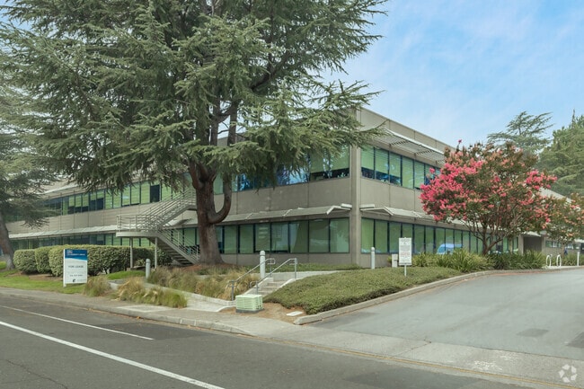
333 University Ave
Sacramento--Roseville--Arden-Arcade, CA
Parcel Map Of Gianulias/Uop Investors
295-0390-014
PARCEL MAP OF GIANULIAS/UOP INVESTORS, LOT 2
Officebuilding
Sacramento
X
California
06067C0183H
2
2024
3.31 AC
2025
Campus Commons
005403
Sacramento
61,152 SF
DEMOGRAPHICS near 333 University Ave
1 Mile
3 Mile
5 Mile
2024 Total Population
16,850
141,276
414,118
2029 Population
17,007
142,669
417,764
Pop Growth 2024-2029
+ 0.93%
+ 0.99%
+ 0.88%
Average Age
41
39
38
2024 Total Households
8,326
60,249
161,792
HH Growth 2024-2029
+ 1.02%
+ 1.03%
+ 0.99%
Median Household Inc
$66,018
$72,904
$66,443
Avg Household Size
1.90
2.20
2.40
2024 Avg HH Vehicles
1.00
2.00
2.00
Median Home Value
$620,694
$529,373
$457,998
Median Year Built
1973
1965
1965
Nearby Places
Map Layers
Map Styles
 Street
 Aerial
- Restaurants
- Banks
- Shops
- Fitness
- Groceries
PUBLIC TRANSPORTATION
AIRPORT
Sacramento International
DRIVE
WALK
Distance
Sacramento International
23 min
19.1 mi
Nearby Properties
Address
Land Use
TOTAL SIZE
Lot Size
Zoning
Address
Land Use
TOTAL SIZE
Lot Size
Zoning
1,095,507 SF
1.39 AC
H-SPD C-2-
Address
Land Use
TOTAL SIZE
Lot Size
Zoning
10.28 AC
H
Address
Land Use
TOTAL SIZE
Lot Size
Zoning
7,742 SF
12.66 AC
M-1S-SWR
Address
Land Use
TOTAL SIZE
Lot Size
Zoning
299,943 SF
4.95 AC
H
Address
Land Use
TOTAL SIZE
Lot Size
Zoning
201,132 SF
28.11 AC
C-2
Address
Land Use
TOTAL SIZE
Lot Size
Zoning
1.33 AC
R-1
Address
Land Use
TOTAL SIZE
Lot Size
Zoning
756,831 SF
1.39 AC
C-2-SPD
Address
Land Use
TOTAL SIZE
Lot Size
Zoning
9.29 AC
R-1 OB-R-P
Address
Land Use
TOTAL SIZE
Lot Size
Zoning
1.15 AC
R-1
Address
Land Use
TOTAL SIZE
Lot Size
Zoning
490,607 SF
32.63 AC
RD-30
Address
Land Use
TOTAL SIZE
Lot Size
Zoning
2.87 AC
C-2
Address
Land Use
TOTAL SIZE
Lot Size
Zoning
31,163 SF
1.57 AC
C-2-TO-SPD
Address
Land Use
TOTAL SIZE
Lot Size
Zoning
10.49 AC
C-2
Address
Land Use
TOTAL SIZE
Lot Size
Zoning
350,049 SF
8.51 AC
MRD-SWR
Address
Land Use
TOTAL SIZE
Lot Size
Zoning
319,856 SF
12.27 AC
R-3-R-PUD
Address
Land Use
TOTAL SIZE
Lot Size
Zoning
226,731 SF
15.73 AC
OB-PUD
Address
Land Use
TOTAL SIZE
Lot Size
Zoning
281,448 SF
13.42 AC
RMX-TO R-2
Address
Land Use
TOTAL SIZE
Lot Size
Zoning
390,860 SF
20.17 AC
R-3-R-PUD
Address
Land Use
TOTAL SIZE
Lot Size
Zoning
320,072 SF
2.65 AC
C-2
Address
Land Use
TOTAL SIZE
Lot Size
Zoning
383,000 SF
25.52 AC
M-1
Address
Land Use
TOTAL SIZE
Lot Size
Zoning
179,178 SF
3.35 AC
RO
Address
Land Use
TOTAL SIZE
Lot Size
Zoning
2.59 AC
OB-R
Address
Land Use
TOTAL SIZE
Lot Size
Zoning
122,425 SF
0.59 AC
C-2-SPD
Address
Land Use
TOTAL SIZE
Lot Size
Zoning
1.15 AC
R-1
Address
Land Use
TOTAL SIZE
Lot Size
Zoning
148,642 SF
7.15 AC
RD-30
Address
Land Use
TOTAL SIZE
Lot Size
Zoning
156,462 SF
8.36 AC
R-3
Address
Land Use
TOTAL SIZE
Lot Size
Zoning
280,519 SF
2.50 AC
C-2-SPD
Address
Land Use
TOTAL SIZE
Lot Size
Zoning
335,346 SF
16.65 AC
SC-R-PUD
Address
Land Use
TOTAL SIZE
Lot Size
Zoning
420,421 SF
25.39 AC
BP
Address
Land Use
TOTAL SIZE
Lot Size
Zoning
258,252 SF
1.66 AC
C-2-SPD
The World's #1 Commercial Real Estate Marketplace
Connect with us
© 2026 CoStar Group
The information above has been obtained from sources believed reliable. While we do not doubt its accuracy we have not verified it and make no guarantee, warranty or representation about it. It is your responsibility to independently confirm its accuracy and completeness. Any projections, opinions, assumptions, or estimates used are for example only and do not represent the current or future performance of the property. The value of this transaction to you depends on tax and other factors which should be evaluated by your tax, financial, and legal advisors. You and your advisors should conduct a careful, independent investigation of the property to determine to your satisfaction the suitability of the property for your needs.