Property Record
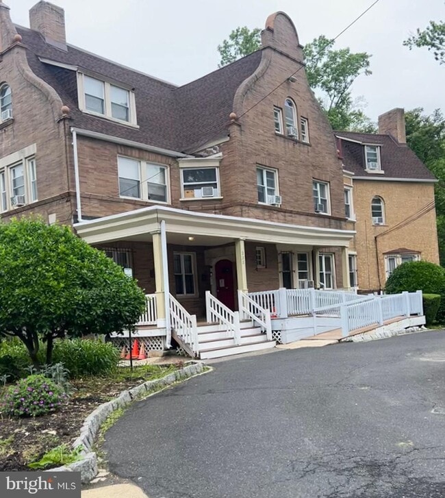
580 Pelham Rd, Philadelphia, PA 19119

This Property Is For Sale
NEARBY LISTINGS FOR SALE OR LEASE
Property Detail
580 Pelham Rd
881097230
NEC UPSAL ST & INTER
Transientlodging
Philadelphia
X
Pennsylvania
42091C0387G
0.55 AC
0
Northwest Philadelphia
2026
Philadelphia
023700
Philadelphia-Camden-Wilmington, PA-NJ-DE-MD
6,506 SF
DEMOGRAPHICS near 580 Pelham Rd
1 Mile
3 Mile
5 Mile
2024 Total Population
30,859
261,874
644,564
2029 Population
29,995
254,504
633,792
Pop Growth 2024-2029
(2.80%)
(2.81%)
(1.67%)
Average Age
42
41
39
2024 Total Households
13,878
114,534
257,305
HH Growth 2024-2029
(3.15%)
(2.94%)
(1.80%)
Median Household Inc
$57,008
$55,178
$50,483
Avg Household Size
2.10
2.20
2.30
2024 Avg HH Vehicles
1.00
1.00
1.00
Median Home Value
$283,563
$223,395
$223,985
Median Year Built
1947
1949
1948
Nearby Places
Map Layers
Map Styles
 Street
 Aerial
- Restaurants
- Banks
- Shops
- Fitness
- Groceries
PUBLIC TRANSPORTATION
COMMUTER RAIL
Upsal (R8 - Southeastern Pennsylvania Transportation Authority Regional Rail (SEPTA Regional Rail))
DRIVE
WALK
Distance
Upsal (R8 - Southeastern Pennsylvania Transportation Authority Regional Rail (SEPTA Regional Rail))
0 min
3 min
0.1 mi
Carpenter (R8 - Southeastern Pennsylvania Transportation Authority Regional Rail (SEPTA Regional Rail))
DRIVE
WALK
Distance
Carpenter (R8 - Southeastern Pennsylvania Transportation Authority Regional Rail (SEPTA Regional Rail))
3 min
13 min
0.7 mi
AIRPORT
Philadelphia International
DRIVE
WALK
Distance
Philadelphia International
34 min
18.3 mi
Trenton Mercer
DRIVE
WALK
Distance
Trenton Mercer
54 min
31.5 mi
Freight Ports
Port of Philadelphia
DRIVE
WALK
Distance
Port of Philadelphia
19 min
8.9 mi
Nearby Properties
Address
Land Use
TOTAL SIZE
Lot Size
Zoning
Address
Land Use
TOTAL SIZE
Lot Size
Zoning
391,885 SF
7.15 AC
RM4
Address
Land Use
TOTAL SIZE
Lot Size
Zoning
638,776 SF
20 AC
RM2
Address
Land Use
TOTAL SIZE
Lot Size
Zoning
455,889 SF
33 AC
I2
Address
Land Use
TOTAL SIZE
Lot Size
Zoning
520,280 SF
14.84 AC
RM3
Address
Land Use
TOTAL SIZE
Lot Size
Zoning
22,648 SF
38.69 AC
RM3
Address
Land Use
TOTAL SIZE
Lot Size
Zoning
451,857 SF
3.57 AC
CMX2
Address
Land Use
TOTAL SIZE
Lot Size
Zoning
609,000 SF
22.44 AC
RM2
Address
Land Use
TOTAL SIZE
Lot Size
Zoning
425,535 SF
4.60 AC
RM3
Address
Land Use
TOTAL SIZE
Lot Size
Zoning
563,768 SF
20.20 AC
RM2
Address
Land Use
TOTAL SIZE
Lot Size
Zoning
253,400 SF
10.90 AC
RM2
Address
Land Use
TOTAL SIZE
Lot Size
Zoning
121,578 SF
3.13 AC
RSA3
Address
Land Use
TOTAL SIZE
Lot Size
Zoning
587,330 SF
34.37 AC
SPINS
Address
Land Use
TOTAL SIZE
Lot Size
Zoning
287,286 SF
1.26 AC
CMX5
Address
Land Use
TOTAL SIZE
Lot Size
Zoning
368,612 SF
20.06 AC
CMX2
Address
Land Use
TOTAL SIZE
Lot Size
Zoning
17,886 SF
80 AC
SPPOA
Address
Land Use
TOTAL SIZE
Lot Size
Zoning
418,017 SF
19.10 AC
CO
Address
Land Use
TOTAL SIZE
Lot Size
Zoning
495,017 SF
9.65 AC
CMX3
Address
Land Use
TOTAL SIZE
Lot Size
Zoning
194,304 SF
9.33 AC
RM2
Address
Land Use
TOTAL SIZE
Lot Size
Zoning
210,738 SF
8.73 AC
RM4
Address
Land Use
TOTAL SIZE
Lot Size
Zoning
218,030 SF
23.75 AC
CA2
Address
Land Use
TOTAL SIZE
Lot Size
Zoning
180,750 SF
1.60 AC
CMX3
Address
Land Use
TOTAL SIZE
Lot Size
Zoning
178,738 SF
6.11 AC
CMX3
Address
Land Use
TOTAL SIZE
Lot Size
Zoning
568,410 SF
33.08 AC
RMX1
Address
Land Use
TOTAL SIZE
Lot Size
Zoning
293,734 SF
4.42 AC
ICMX
Address
Land Use
TOTAL SIZE
Lot Size
Zoning
305,100 SF
5.28 AC
RM4
Address
Land Use
TOTAL SIZE
Lot Size
Zoning
394,649 SF
27.93 AC
C0
Address
Land Use
TOTAL SIZE
Lot Size
Zoning
249,341 SF
21.82 AC
CA2
Address
Land Use
TOTAL SIZE
Lot Size
Zoning
415,059 SF
11.59 AC
RSD3
Address
Land Use
TOTAL SIZE
Lot Size
Zoning
211,200 SF
1.46 AC
CMX2
Address
Land Use
TOTAL SIZE
Lot Size
Zoning
408,216 SF
16.62 AC
C0
The World's #1 Commercial Real Estate Marketplace
Connect with us
© 2026 CoStar Group
The information above has been obtained from sources believed reliable. While we do not doubt its accuracy we have not verified it and make no guarantee, warranty or representation about it. It is your responsibility to independently confirm its accuracy and completeness. Any projections, opinions, assumptions, or estimates used are for example only and do not represent the current or future performance of the property. The value of this transaction to you depends on tax and other factors which should be evaluated by your tax, financial, and legal advisors. You and your advisors should conduct a careful, independent investigation of the property to determine to your satisfaction the suitability of the property for your needs.