Property Record
3331 Rinconada Blvd, Las Cruces, NM 88011


NEARBY LISTINGS FOR SALE OR LEASE
Property Detail
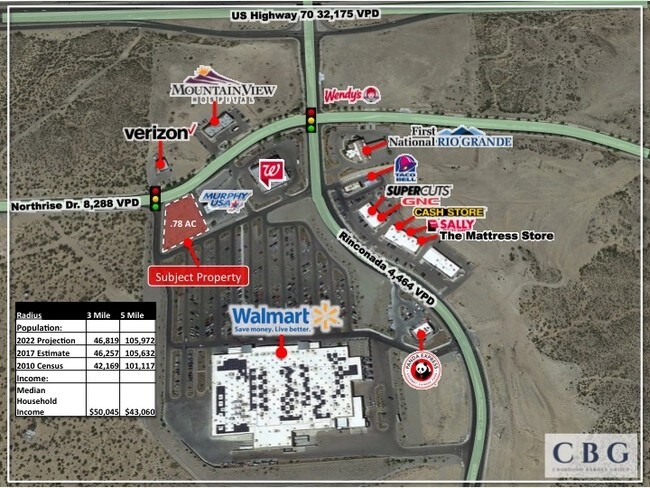
3331 Rinconada Blvd
Las Cruces, NM
Pueblo De Las Alamedas
02-39600
SUBD: PUEBLO DE LAS ALAMEDAS REPLAT NO 1 (BK 22 PG 281-286 - 0727584) LOT: 20 S: 28 T: 22S R: 2E
Commercialacreage
Dona Ana
X
New Mexico
35013C1101G
20
2024
25.05 AC
2025
Las Cruces/Alamogordo
001210
Other Market Areas
195,560 SF
DEMOGRAPHICS near 3331 Rinconada Blvd
1 Mile
3 Mile
5 Mile
2024 Total Population
4,952
58,990
121,193
2029 Population
5,262
62,573
127,995
Pop Growth 2024-2029
+ 6.26%
+ 6.07%
+ 5.61%
Average Age
40
38
38
2024 Total Households
2,135
23,089
48,818
HH Growth 2024-2029
+ 6.42%
+ 6.12%
+ 5.63%
Median Household Inc
$77,588
$60,330
$47,881
Avg Household Size
2.30
2.50
2.40
2024 Avg HH Vehicles
2.00
2.00
2.00
Median Home Value
$256,160
$213,251
$188,763
Median Year Built
2004
2001
1990
Nearby Places
Map Layers
Map Styles
 Street
 Aerial
- Restaurants
- Banks
- Shops
- Fitness
- Groceries
SALE & LEASE HISTORY
LISTING DATE
SALE/LEASE

Aug 08, 2017
For Lease
Nearby Properties
Address
Land Use
TOTAL SIZE
Lot Size
Zoning
Address
Land Use
TOTAL SIZE
Lot Size
Zoning
266,671 SF
23.96 AC
PUD
Address
Land Use
TOTAL SIZE
Lot Size
Zoning
106,866 SF
10.61 AC
R1
Address
Land Use
TOTAL SIZE
Lot Size
Zoning
280,731 SF
15.55 AC
PUD
Address
Land Use
TOTAL SIZE
Lot Size
Zoning
29,466 SF
1.33 AC
C2
Address
Land Use
TOTAL SIZE
Lot Size
Zoning
78,452 SF
60 AC
A2
Address
Land Use
TOTAL SIZE
Lot Size
Zoning
66,410 SF
7 AC
PUD
Address
Land Use
TOTAL SIZE
Lot Size
Zoning
6,232 SF
22.74 AC
C2
Address
Land Use
TOTAL SIZE
Lot Size
Zoning
154,592 SF
14.12 AC
A2
Address
Land Use
TOTAL SIZE
Lot Size
Zoning
170,972 SF
16.38 AC
R4
Address
Land Use
TOTAL SIZE
Lot Size
Zoning
135,605 SF
6 AC
PUD
Address
Land Use
TOTAL SIZE
Lot Size
Zoning
49,295 SF
6.29 AC
R3
Address
Land Use
TOTAL SIZE
Lot Size
Zoning
7,483 SF
16.15 AC
PUD
Address
Land Use
TOTAL SIZE
Lot Size
Zoning
65,535 SF
5.64 AC
R1
Address
Land Use
TOTAL SIZE
Lot Size
Zoning
14.47 AC
R4
Address
Land Use
TOTAL SIZE
Lot Size
Zoning
78,845 SF
14.81 AC
A2
Address
Land Use
TOTAL SIZE
Lot Size
Zoning
132,179 SF
14.24 AC
M1
Address
Land Use
TOTAL SIZE
Lot Size
Zoning
44,506 SF
C2
Address
Land Use
TOTAL SIZE
Lot Size
Zoning
119,985 SF
6 AC
R1
Address
Land Use
TOTAL SIZE
Lot Size
Zoning
136,629 SF
15.78 AC
C2
Address
Land Use
TOTAL SIZE
Lot Size
Zoning
62,645 SF
5.50 AC
R3
Address
Land Use
TOTAL SIZE
Lot Size
Zoning
102,505 SF
6.44 AC
PUD
Address
Land Use
TOTAL SIZE
Lot Size
Zoning
21,048 SF
22.24 AC
C2
Address
Land Use
TOTAL SIZE
Lot Size
Zoning
22,456 SF
1.93 AC
PUD
Address
Land Use
TOTAL SIZE
Lot Size
Zoning
85,310 SF
5.23 AC
R2
Address
Land Use
TOTAL SIZE
Lot Size
Zoning
36,799 SF
2.08 AC
PUD
Address
Land Use
TOTAL SIZE
Lot Size
Zoning
109,641 SF
12.01 AC
M1
Address
Land Use
TOTAL SIZE
Lot Size
Zoning
51,916 SF
4.19 AC
M1
The World's #1 Commercial Real Estate Marketplace
Connect with us
© 2026 CoStar Group
The information above has been obtained from sources believed reliable. While we do not doubt its accuracy we have not verified it and make no guarantee, warranty or representation about it. It is your responsibility to independently confirm its accuracy and completeness. Any projections, opinions, assumptions, or estimates used are for example only and do not represent the current or future performance of the property. The value of this transaction to you depends on tax and other factors which should be evaluated by your tax, financial, and legal advisors. You and your advisors should conduct a careful, independent investigation of the property to determine to your satisfaction the suitability of the property for your needs.