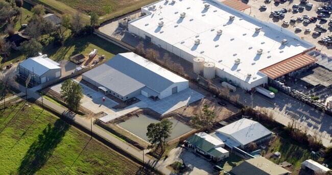
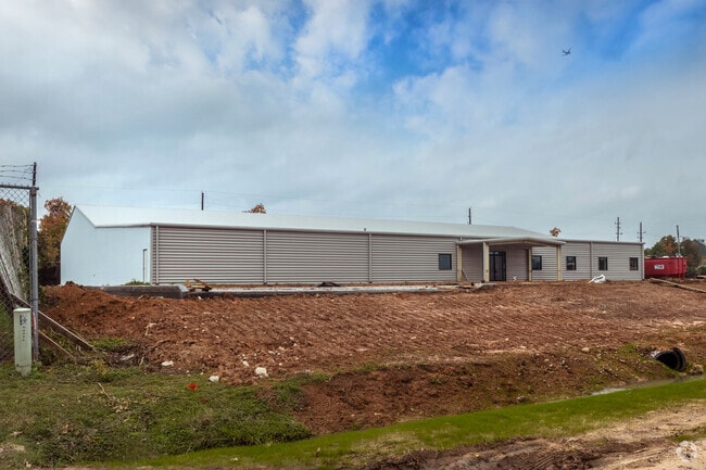
Property Record
33315 Katy Lee Ln, Magnolia, TX 77354
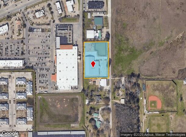
NEARBY LISTINGS FOR SALE OR LEASE
Property Detail
33315 Katy Lee Ln
Houston-The Woodlands-Sugar Land, TX
Green Hills
5430-01-01400
S543001 - GREEN HILLS, LOT 14, 16, 18, 20, 22, ACRES 2.34
Commercialnec
Montgomery
X
Texas
48339C0510G
14,16
2024
2.34 AC
2025
The Woodlands/Conroe
690608
Houston
27,250 SF
DEMOGRAPHICS near 33315 Katy Lee Ln
1 Mile
3 Mile
5 Mile
2024 Total Population
8,408
53,139
122,388
2029 Population
10,334
64,795
149,095
Pop Growth 2024-2029
+ 22.91%
+ 21.93%
+ 21.82%
Average Age
39
39
39
2024 Total Households
3,176
18,532
43,420
HH Growth 2024-2029
+ 23.30%
+ 22.19%
+ 22.03%
Median Household Inc
$115,402
$137,105
$129,773
Avg Household Size
2.60
2.80
2.80
2024 Avg HH Vehicles
2.00
2.00
2.00
Median Home Value
$332,373
$412,255
$392,320
Median Year Built
2007
2003
2005
Nearby Places
- Restaurants
- Banks
- Shops
- Fitness
- Groceries
PUBLIC TRANSPORTATION
AIRPORT
George Bush Intcntl/Houston
DRIVE
WALK
Distance
George Bush Intcntl/Houston
41 min
32.1 mi
Freight Ports
Port of Houston
DRIVE
WALK
Distance
Port of Houston
64 min
47.8 mi
SALE & LEASE HISTORY
LISTING DATE
SALE/LEASE

Nov 12, 2018
For Sale
Dec 10, 2019
For Lease
Aug 23, 2022
For Lease
Aug 23, 2022
For Sale
Nearby Properties
Address
Land Use
TOTAL SIZE
Lot Size
Zoning
Address
Land Use
TOTAL SIZE
Lot Size
Zoning
370,029 SF
16.12 AC
Address
Land Use
TOTAL SIZE
Lot Size
Zoning
392,613 SF
19.35 AC
2
Address
Land Use
TOTAL SIZE
Lot Size
Zoning
361,747 SF
16.71 AC
Address
Land Use
TOTAL SIZE
Lot Size
Zoning
367,449 SF
7.78 AC
Address
Land Use
TOTAL SIZE
Lot Size
Zoning
296,538 SF
12.58 AC
Address
Land Use
TOTAL SIZE
Lot Size
Zoning
426,425 SF
8.74 AC
Address
Land Use
TOTAL SIZE
Lot Size
Zoning
295,608 SF
10.07 AC
6
Address
Land Use
TOTAL SIZE
Lot Size
Zoning
194,272 SF
11.06 AC
Address
Land Use
TOTAL SIZE
Lot Size
Zoning
289,611 SF
13.57 AC
Address
Land Use
TOTAL SIZE
Lot Size
Zoning
203,460 SF
39.49 AC
2
Address
Land Use
TOTAL SIZE
Lot Size
Zoning
222,687 SF
8.03 AC
2
Address
Land Use
TOTAL SIZE
Lot Size
Zoning
198,969 SF
32.78 AC
Address
Land Use
TOTAL SIZE
Lot Size
Zoning
141,496 SF
18.30 AC
2
Address
Land Use
TOTAL SIZE
Lot Size
Zoning
190,824 SF
3.62 AC
Address
Land Use
TOTAL SIZE
Lot Size
Zoning
139,140 SF
18.22 AC
6
Address
Land Use
TOTAL SIZE
Lot Size
Zoning
13.76 AC
Address
Land Use
TOTAL SIZE
Lot Size
Zoning
107,000 SF
4.81 AC
Address
Land Use
TOTAL SIZE
Lot Size
Zoning
211,965 SF
25.17 AC
Address
Land Use
TOTAL SIZE
Lot Size
Zoning
76,599 SF
6.17 AC
Address
Land Use
TOTAL SIZE
Lot Size
Zoning
172,784 SF
20.60 AC
2
Address
Land Use
TOTAL SIZE
Lot Size
Zoning
278,939 SF
13.76 AC
Address
Land Use
TOTAL SIZE
Lot Size
Zoning
190,000 SF
24.21 AC
Address
Land Use
TOTAL SIZE
Lot Size
Zoning
165,218 SF
17.40 AC
2
Address
Land Use
TOTAL SIZE
Lot Size
Zoning
51,134 SF
25 AC
2
Address
Land Use
TOTAL SIZE
Lot Size
Zoning
94,128 SF
51.19 AC
2
Address
Land Use
TOTAL SIZE
Lot Size
Zoning
77,299 SF
7.08 AC
Address
Land Use
TOTAL SIZE
Lot Size
Zoning
133,266 SF
2.95 AC
2
Address
Land Use
TOTAL SIZE
Lot Size
Zoning
122,940 SF
17.10 AC
6
Address
Land Use
TOTAL SIZE
Lot Size
Zoning
1,440 SF
126.83 AC
2
Address
Land Use
TOTAL SIZE
Lot Size
Zoning
151,978 SF
21.94 AC
The World's #1 Commercial Real Estate Marketplace
Connect with us
© 2025 CoStar Group
The information above has been obtained from sources believed reliable. While we do not doubt its accuracy we have not verified it and make no guarantee, warranty or representation about it. It is your responsibility to independently confirm its accuracy and completeness. Any projections, opinions, assumptions, or estimates used are for example only and do not represent the current or future performance of the property. The value of this transaction to you depends on tax and other factors which should be evaluated by your tax, financial, and legal advisors. You and your advisors should conduct a careful, independent investigation of the property to determine to your satisfaction the suitability of the property for your needs.