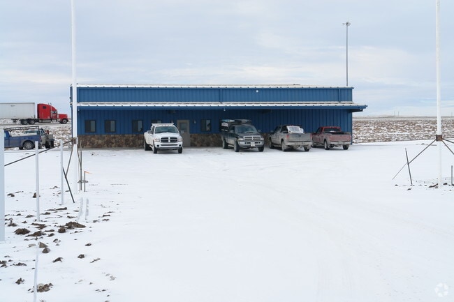
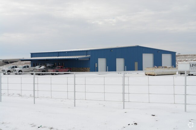
Property Record
3332 Nebraska Rd, Ottawa, KS 66067
NEARBY LISTINGS FOR SALE OR LEASE
Property Detail
3332 Nebraska Rd
099-30-0-00-00-019.00-0
S30, T16, R20E, ACRES 7.6, TR BEG 163.5N SE/C SE4 N260.8 E113 NLY409.8 WLY41.7 N509 W384.9 S114.2 SELY1079 E132.3 TO POB
Warehouse
Franklin
X
Kansas
20059C0090E
7.64 AC
2024
Ottawa
2025
Kansas City
954500
Ottawa, KS
7,500 SF
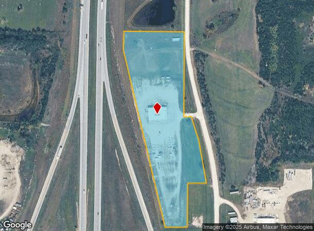
DEMOGRAPHICS near 3332 Nebraska Rd
1 Mile
3 Mile
5 Mile
2024 Total Population
168
10,939
14,601
2029 Population
169
11,088
14,770
Pop Growth 2024-2029
+ 0.60%
+ 1.36%
+ 1.16%
Average Age
41
39
39
2024 Total Households
69
4,343
5,855
HH Growth 2024-2029
0.00%
+ 1.36%
+ 1.16%
Median Household Inc
$68,499
$60,452
$61,451
Avg Household Size
2.40
2.40
2.40
2024 Avg HH Vehicles
3.00
2.00
2.00
Median Home Value
$146,153
$140,115
$152,496
Median Year Built
1979
1963
1969
Nearby Places
Map Layers
Map Styles
 Street
 Aerial
- Restaurants
- Banks
- Shops
- Fitness
- Groceries
SALE & LEASE HISTORY
LISTING DATE
SALE/LEASE

May 30, 2018
For Lease
May 30, 2018
For Sale
Nearby Properties
Address
Land Use
TOTAL SIZE
Lot Size
Zoning
Address
Land Use
TOTAL SIZE
Lot Size
Zoning
115,413 SF
7.63 AC
O1
Address
Land Use
TOTAL SIZE
Lot Size
Zoning
35,262 SF
33.20 AC
R
Address
Land Use
TOTAL SIZE
Lot Size
Zoning
63,811 SF
17.60 AC
MH
Address
Land Use
TOTAL SIZE
Lot Size
Zoning
1,124,676 SF
208.76 AC
I1SX
Address
Land Use
TOTAL SIZE
Lot Size
Zoning
52,556 SF
26.31 AC
C2
Address
Land Use
TOTAL SIZE
Lot Size
Zoning
79,735 SF
3.20 AC
C3
Address
Land Use
TOTAL SIZE
Lot Size
Zoning
17,373 SF
82.20 AC
I1
Address
Land Use
TOTAL SIZE
Lot Size
Zoning
50,753 SF
7.30 AC
R
Address
Land Use
TOTAL SIZE
Lot Size
Zoning
18,000 SF
5.04 AC
RS
Address
Land Use
TOTAL SIZE
Lot Size
Zoning
15,895 SF
1.06 AC
R1
Address
Land Use
TOTAL SIZE
Lot Size
Zoning
285,548 SF
26.93 AC
I1
Address
Land Use
TOTAL SIZE
Lot Size
Zoning
49,756 SF
4.16 AC
C2
Address
Land Use
TOTAL SIZE
Lot Size
Zoning
33,454 SF
1.36 AC
R2
Address
Land Use
TOTAL SIZE
Lot Size
Zoning
21,707 SF
1.12 AC
C3
Address
Land Use
TOTAL SIZE
Lot Size
Zoning
31,788 SF
1.55 AC
C3
Address
Land Use
TOTAL SIZE
Lot Size
Zoning
1.60 AC
Address
Land Use
TOTAL SIZE
Lot Size
Zoning
90,000 SF
41.40 AC
I2
Address
Land Use
TOTAL SIZE
Lot Size
Zoning
Address
Land Use
TOTAL SIZE
Lot Size
Zoning
27,933 SF
0.69 AC
C3
Address
Land Use
TOTAL SIZE
Lot Size
Zoning
18,978 SF
2.17 AC
R
Address
Land Use
TOTAL SIZE
Lot Size
Zoning
11,456 SF
10.05 AC
RE
Address
Land Use
TOTAL SIZE
Lot Size
Zoning
24,478 SF
3.30 AC
R
Address
Land Use
TOTAL SIZE
Lot Size
Zoning
13,901 SF
0.95 AC
C1
Address
Land Use
TOTAL SIZE
Lot Size
Zoning
32.37 AC
R1
Address
Land Use
TOTAL SIZE
Lot Size
Zoning
15,000 SF
11.91 AC
RS
Address
Land Use
TOTAL SIZE
Lot Size
Zoning
58,274 SF
6.94 AC
C2
Address
Land Use
TOTAL SIZE
Lot Size
Zoning
12,000 SF
0.34 AC
R2
Address
Land Use
TOTAL SIZE
Lot Size
Zoning
12,000 SF
0.47 AC
C3
Address
Land Use
TOTAL SIZE
Lot Size
Zoning
24,496 SF
0.34 AC
C3
Address
Land Use
TOTAL SIZE
Lot Size
Zoning
8,020 SF
22 AC
I1
The World's #1 Commercial Real Estate Marketplace
Connect with us
© 2026 CoStar Group
The information above has been obtained from sources believed reliable. While we do not doubt its accuracy we have not verified it and make no guarantee, warranty or representation about it. It is your responsibility to independently confirm its accuracy and completeness. Any projections, opinions, assumptions, or estimates used are for example only and do not represent the current or future performance of the property. The value of this transaction to you depends on tax and other factors which should be evaluated by your tax, financial, and legal advisors. You and your advisors should conduct a careful, independent investigation of the property to determine to your satisfaction the suitability of the property for your needs.