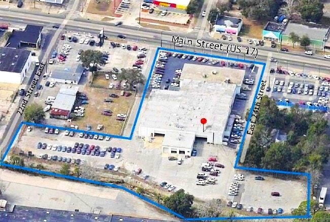
Property Record
3333 N Main St, Jacksonville, FL 32206


Current Lease Availabilities
NEARBY LISTINGS FOR SALE OR LEASE
Property Detail
3333 N Main St
Jacksonville, FL
Lonb Branch Blk L
133434-0000
AH-526 55-2S-26E 2.93 LONG BRANCH LOTS 8,9,10,PT CL ST RECD O/R 16901-1664 BLK L
Vehiclerentalsvehiclesales
Duval
X
Florida
12031C0357J
8,9,1
2024
2.94 AC
2025
Downtown
001300
Jacksonville (Florida)
36,624 SF
DEMOGRAPHICS near 3333 N Main St
1 Mile
3 Mile
5 Mile
2024 Total Population
12,528
80,991
206,027
2029 Population
13,425
86,233
217,886
Pop Growth 2024-2029
+ 7.16%
+ 6.47%
+ 5.76%
Average Age
38
38
39
2024 Total Households
5,168
32,533
84,446
HH Growth 2024-2029
+ 7.26%
+ 6.81%
+ 6.03%
Median Household Inc
$28,196
$30,740
$38,952
Avg Household Size
2.40
2.30
2.30
2024 Avg HH Vehicles
1.00
1.00
1.00
Median Home Value
$131,072
$119,275
$160,412
Median Year Built
1953
1962
1963
Nearby Places
Map Layers
Map Styles
 Street
 Aerial
- Restaurants
- Banks
- Shops
- Fitness
- Groceries
PUBLIC TRANSPORTATION
COMMUTER RAIL
DRIVE
WALK
Distance
9 min
4.7 mi
AIRPORT
Jacksonville International
DRIVE
WALK
Distance
Jacksonville International
21 min
13.4 mi
Freight Ports
Jacksonville Port
DRIVE
WALK
Distance
Jacksonville Port
6 min
2.0 mi
Nearby Properties
Address
Land Use
TOTAL SIZE
Lot Size
Zoning
Address
Land Use
TOTAL SIZE
Lot Size
Zoning
543,383 SF
7.87 AC
CCBD
Address
Land Use
TOTAL SIZE
Lot Size
Zoning
1,150,143 SF
43.90 AC
CCBD
Address
Land Use
TOTAL SIZE
Lot Size
Zoning
705,940 SF
25.12 AC
PBF-1
Address
Land Use
TOTAL SIZE
Lot Size
Zoning
1,146,106 SF
206.66 AC
PBF-2
Address
Land Use
TOTAL SIZE
Lot Size
Zoning
407,122 SF
4.50 AC
CCBD
Address
Land Use
TOTAL SIZE
Lot Size
Zoning
165,408 SF
2.45 AC
CCBD
Address
Land Use
TOTAL SIZE
Lot Size
Zoning
521,850 SF
10.06 AC
CCBD
Address
Land Use
TOTAL SIZE
Lot Size
Zoning
831,560 SF
1.16 AC
PUD
Address
Land Use
TOTAL SIZE
Lot Size
Zoning
187,278 SF
1.71 AC
CCBD
Address
Land Use
TOTAL SIZE
Lot Size
Zoning
127,732 SF
1.44 AC
CCBD
Address
Land Use
TOTAL SIZE
Lot Size
Zoning
313,472 SF
35.44 AC
CCBD
Address
Land Use
TOTAL SIZE
Lot Size
Zoning
146,636 SF
2.88 AC
CCBD
Address
Land Use
TOTAL SIZE
Lot Size
Zoning
264,277 SF
2.07 AC
CCBD
Address
Land Use
TOTAL SIZE
Lot Size
Zoning
369,638 SF
6.30 AC
CCBD
Address
Land Use
TOTAL SIZE
Lot Size
Zoning
326,485 SF
1.56 AC
CCBD
Address
Land Use
TOTAL SIZE
Lot Size
Zoning
992,501 SF
2.97 AC
CCBD
Address
Land Use
TOTAL SIZE
Lot Size
Zoning
503,858 SF
1.32 AC
CCBD
Address
Land Use
TOTAL SIZE
Lot Size
Zoning
194,877 SF
11.64 AC
CCBD
Address
Land Use
TOTAL SIZE
Lot Size
Zoning
453,728 SF
8.20 AC
CCBD
Address
Land Use
TOTAL SIZE
Lot Size
Zoning
299,055 SF
18.93 AC
CCBD
Address
Land Use
TOTAL SIZE
Lot Size
Zoning
212,152 SF
8.17 AC
CCBD
Address
Land Use
TOTAL SIZE
Lot Size
Zoning
270,000 SF
8.90 AC
PUD
Address
Land Use
TOTAL SIZE
Lot Size
Zoning
700,443 SF
8 AC
CCBD
Address
Land Use
TOTAL SIZE
Lot Size
Zoning
329,412 SF
1.75 AC
CCBD
Address
Land Use
TOTAL SIZE
Lot Size
Zoning
189,151 SF
3.57 AC
PUD
Address
Land Use
TOTAL SIZE
Lot Size
Zoning
213,439 SF
1.96 AC
CCBD
Address
Land Use
TOTAL SIZE
Lot Size
Zoning
165,035 SF
1.52 AC
CCBD
Address
Land Use
TOTAL SIZE
Lot Size
Zoning
163,471 SF
7.85 AC
PBF-2
Address
Land Use
TOTAL SIZE
Lot Size
Zoning
488,100 SF
35.32 AC
CRO
Address
Land Use
TOTAL SIZE
Lot Size
Zoning
125,571 SF
5.97 AC
CCBD
The World's #1 Commercial Real Estate Marketplace
Connect with us
© 2025 CoStar Group
The information above has been obtained from sources believed reliable. While we do not doubt its accuracy we have not verified it and make no guarantee, warranty or representation about it. It is your responsibility to independently confirm its accuracy and completeness. Any projections, opinions, assumptions, or estimates used are for example only and do not represent the current or future performance of the property. The value of this transaction to you depends on tax and other factors which should be evaluated by your tax, financial, and legal advisors. You and your advisors should conduct a careful, independent investigation of the property to determine to your satisfaction the suitability of the property for your needs.