Property Record
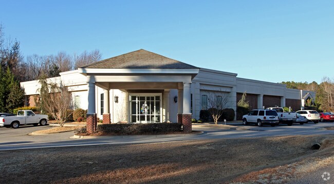
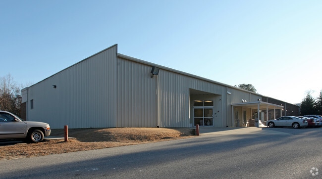
3333 Nc Highway 242 N, Benson, NC 27504

Property Detail
3333 Nc Highway 242 N
01E08020G
DR TURLINGTON 49/107 1630
Medicalbuilding
JOHNSTON
COM
North Carolina
B and X Area of moderate flood hazard, usually the area between the limits of the 100-year and 500-year floods.
2.73 AC
0
Johnston County
2025
Raleigh/Durham
041402
Raleigh-Cary, NC
14,699 SF
NEARBY LISTINGS FOR SALE OR LEASE
-
-
View all Benson listings for sale on LoopNet.com
DEMOGRAPHICS near 3333 Nc Highway 242 N
1 mile
3 mile
5 mile
2025 Total Population
812
8,629
18,121
2030 Population
922
9,736
20,320
Pop Growth 2025-2030
+ 13.55%
+ 12.83%
+ 12.14%
Average Age
41
40
40
2025 Total Households
296
3,321
6,953
HH Growth 2025-2030
+ 13.51%
+ 12.92%
+ 12.20%
Median Household Inc
$82,608
$70,650
$65,550
Avg Household Size
2.60
2.50
2.50
2025 Avg HH Vehicles
2.00
2.00
2.00
Median Home Value
$280,146
$271,602
$269,681
Median Year Built
1996
1988
1990
Nearby Places
Map Layers
Map Styles
 Street
 Aerial
Layers
 Traffic
 Biking
Places
Listings with unknown addresses are not visible on the map
- Restaurants
- Banks
- Shops
- Fitness
- Groceries
PUBLIC TRANSPORTATION
AIRPORT
Fayetteville Regional/Grannis Field
Drive
Walk
Distance
Fayetteville Regional/Grannis Field
50 min
39.4 mi
Raleigh-Durham International
Drive
Walk
Distance
Raleigh-Durham International
53 min
43.7 mi
Nearby Properties
Address
Land Use
TOTAL SIZE
Lot Size
Zoning
Address
Land Use
TOTAL SIZE
Lot Size
Zoning
140,487 SF
61.33 AC
RAG
Address
Land Use
TOTAL SIZE
Lot Size
Zoning
145,754 SF
19.40 AC
IND
Address
Land Use
TOTAL SIZE
Lot Size
Zoning
16,412 SF
22.86 AC
RES
Address
Land Use
TOTAL SIZE
Lot Size
Zoning
17,408 SF
32.38 AC
RES
Address
Land Use
TOTAL SIZE
Lot Size
Zoning
319,020 SF
17.30 AC
IND
Address
Land Use
TOTAL SIZE
Lot Size
Zoning
43,683 SF
14.64 AC
RES
Address
Land Use
TOTAL SIZE
Lot Size
Zoning
71,496 SF
2.11 AC
RES
Address
Land Use
TOTAL SIZE
Lot Size
Zoning
1,188 SF
33 AC
IND
Address
Land Use
TOTAL SIZE
Lot Size
Zoning
5,399 SF
0.94 AC
SUP
Address
Land Use
TOTAL SIZE
Lot Size
Zoning
24,060 SF
3.34 AC
COM
Address
Land Use
TOTAL SIZE
Lot Size
Zoning
54,851 SF
8.47 AC
RES
Address
Land Use
TOTAL SIZE
Lot Size
Zoning
1,280 SF
64.02 AC
COM
Address
Land Use
TOTAL SIZE
Lot Size
Zoning
4,252 SF
4.94 AC
SUP
Address
Land Use
TOTAL SIZE
Lot Size
Zoning
70,250 SF
9.57 AC
IND
Address
Land Use
TOTAL SIZE
Lot Size
Zoning
18,492 SF
1.16 AC
RES
Address
Land Use
TOTAL SIZE
Lot Size
Zoning
3,533 SF
4.83 AC
RES
Address
Land Use
TOTAL SIZE
Lot Size
Zoning
2,160 SF
5.83 AC
RES
Address
Land Use
TOTAL SIZE
Lot Size
Zoning
1,196 SF
10.05 AC
COM
Address
Land Use
TOTAL SIZE
Lot Size
Zoning
5,187 SF
0.48 AC
OFR
Address
Land Use
TOTAL SIZE
Lot Size
Zoning
8,400 SF
7.18 AC
COM
Address
Land Use
TOTAL SIZE
Lot Size
Zoning
22,000 SF
6.10 AC
COM
Address
Land Use
TOTAL SIZE
Lot Size
Zoning
9,588 SF
1.11 AC
COM
Address
Land Use
TOTAL SIZE
Lot Size
Zoning
3,676 SF
1.21 AC
COM
Address
Land Use
TOTAL SIZE
Lot Size
Zoning
4,408 SF
3.71 AC
COM
Address
Land Use
TOTAL SIZE
Lot Size
Zoning
4,000 SF
5.09 AC
COM
Address
Land Use
TOTAL SIZE
Lot Size
Zoning
20,000 SF
8.49 AC
IND
Address
Land Use
TOTAL SIZE
Lot Size
Zoning
3,452 SF
5.20 AC
RES
Address
Land Use
TOTAL SIZE
Lot Size
Zoning
134.81 AC
IND
Address
Land Use
TOTAL SIZE
Lot Size
Zoning
6,286 SF
4.98 AC
OFR
Address
Land Use
TOTAL SIZE
Lot Size
Zoning
20,250 SF
18.42 AC
COM
The World's #1 Commercial Real Estate Marketplace
Connect with us
© 2026 CoStar Group
The information above has been obtained from sources believed reliable. While we do not doubt its accuracy we have not verified it and make no guarantee, warranty or representation about it. It is your responsibility to independently confirm its accuracy and completeness. Any projections, opinions, assumptions, or estimates used are for example only and do not represent the current or future performance of the property. The value of this transaction to you depends on tax and other factors which should be evaluated by your tax, financial, and legal advisors. You and your advisors should conduct a careful, independent investigation of the property to determine to your satisfaction the suitability of the property for your needs.