Property Record
3333 W 159Th St, Markham, IL 60428
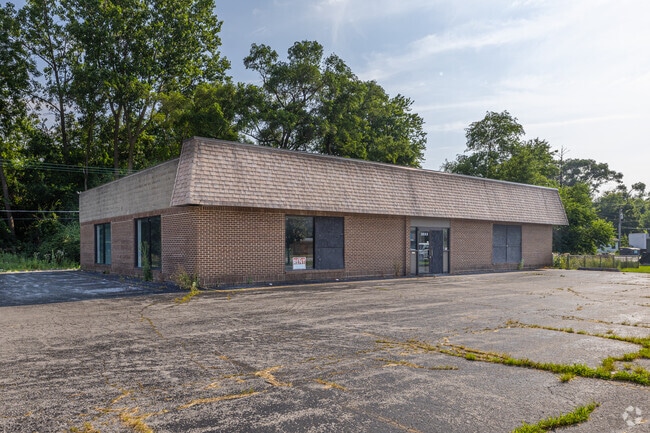

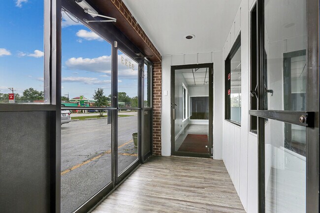
Property Detail
3333 W 159Th St
28-23-204-003-0000
Cook
Commercialbuilding
Illinois
B and X Area of moderate flood hazard, usually the area between the limits of the 100-year and 500-year floods.
3
2023
0.16 AC
2025
Near South Cook
825600
Chicago
3,950 SF
Chicago-Naperville-Elgin, IL-IN
NEARBY LISTINGS FOR SALE OR LEASE
DEMOGRAPHICS near 3333 W 159Th St
1 mile
3 mile
5 mile
2025 Total Population
8,654
97,560
248,621
2030 Population
8,922
100,061
254,088
Pop Growth 2025-2030
+ 3.10%
+ 2.56%
+ 2.20%
Average Age
39
40
41
2025 Total Households
2,763
33,944
92,167
HH Growth 2025-2030
+ 2.86%
+ 2.40%
+ 2.05%
Median Household Inc
$60,842
$61,275
$68,843
Avg Household Size
2.90
2.70
2.60
2025 Avg HH Vehicles
2.00
2.00
2.00
Median Home Value
$146,464
$180,480
$194,961
Median Year Built
1962
1968
1968
Nearby Places
Map Layers
Map Styles
 Street
 Aerial
Layers
 Traffic
 Biking
Places
Listings with unknown addresses are not visible on the map
- Restaurants
- Banks
- Shops
- Fitness
- Groceries
PUBLIC TRANSPORTATION
COMMUTER RAIL
Oak Forest Station (Rock Island District Line - Northeast Illinois Regional Commuter Railroad (Metra))
Drive
Walk
Distance
Oak Forest Station (Rock Island District Line - Northeast Illinois Regional Commuter Railroad (Metra))
4 min
2.2 mi
Midlothian Station (Rock Island District Line - Northeast Illinois Regional Commuter Railroad (Metra))
Drive
Walk
Distance
Midlothian Station (Rock Island District Line - Northeast Illinois Regional Commuter Railroad (Metra))
5 min
2.7 mi
AIRPORT
Chicago Midway International
Drive
Walk
Distance
Chicago Midway International
26 min
15.8 mi
Chicago O'Hare International
Drive
Walk
Distance
Chicago O'Hare International
51 min
37.6 mi
Freight Ports
Port Milwaukee
Drive
Walk
Distance
Port Milwaukee
132 min
109.3 mi
SALE & LEASE HISTORY
LISTING DATE
SALE/LEASE

Jul 24, 2025
For Lease
Aug 03, 2021
For Sale
Nearby Properties
Address
Land Use
TOTAL SIZE
Lot Size
Zoning
Address
Land Use
TOTAL SIZE
Lot Size
Zoning
1.45 AC
Address
Land Use
TOTAL SIZE
Lot Size
Zoning
Address
Land Use
TOTAL SIZE
Lot Size
Zoning
Address
Land Use
TOTAL SIZE
Lot Size
Zoning
44,184 SF
5 AC
Address
Land Use
TOTAL SIZE
Lot Size
Zoning
203,995 SF
20.27 AC
Address
Land Use
TOTAL SIZE
Lot Size
Zoning
62,380 SF
4.65 AC
Address
Land Use
TOTAL SIZE
Lot Size
Zoning
Address
Land Use
TOTAL SIZE
Lot Size
Zoning
Address
Land Use
TOTAL SIZE
Lot Size
Zoning
67,314 SF
1.19 AC
Address
Land Use
TOTAL SIZE
Lot Size
Zoning
49,229 SF
1.31 AC
Address
Land Use
TOTAL SIZE
Lot Size
Zoning
132,322 SF
2 AC
Address
Land Use
TOTAL SIZE
Lot Size
Zoning
Address
Land Use
TOTAL SIZE
Lot Size
Zoning
1.38 AC
Address
Land Use
TOTAL SIZE
Lot Size
Zoning
15,150 SF
1.64 AC
Address
Land Use
TOTAL SIZE
Lot Size
Zoning
20,579 SF
1.14 AC
Address
Land Use
TOTAL SIZE
Lot Size
Zoning
59,497 SF
5.10 AC
Address
Land Use
TOTAL SIZE
Lot Size
Zoning
5.42 AC
Address
Land Use
TOTAL SIZE
Lot Size
Zoning
185,463 SF
10.96 AC
Address
Land Use
TOTAL SIZE
Lot Size
Zoning
Address
Land Use
TOTAL SIZE
Lot Size
Zoning
66,320 SF
12.11 AC
Address
Land Use
TOTAL SIZE
Lot Size
Zoning
90,220 SF
2.21 AC
Address
Land Use
TOTAL SIZE
Lot Size
Zoning
93,559 SF
9.97 AC
Address
Land Use
TOTAL SIZE
Lot Size
Zoning
68,208 SF
1.28 AC
Address
Land Use
TOTAL SIZE
Lot Size
Zoning
2,320 SF
18 AC
Address
Land Use
TOTAL SIZE
Lot Size
Zoning
36,920 SF
14.86 AC
Address
Land Use
TOTAL SIZE
Lot Size
Zoning
28.54 AC
Address
Land Use
TOTAL SIZE
Lot Size
Zoning
Address
Land Use
TOTAL SIZE
Lot Size
Zoning
6,990 SF
0.68 AC
Address
Land Use
TOTAL SIZE
Lot Size
Zoning
63,900 SF
6.21 AC
The World's #1 Commercial Real Estate Marketplace
Connect with us
© 2026 CoStar Group
The information above has been obtained from sources believed reliable. While we do not doubt its accuracy we have not verified it and make no guarantee, warranty or representation about it. It is your responsibility to independently confirm its accuracy and completeness. Any projections, opinions, assumptions, or estimates used are for example only and do not represent the current or future performance of the property. The value of this transaction to you depends on tax and other factors which should be evaluated by your tax, financial, and legal advisors. You and your advisors should conduct a careful, independent investigation of the property to determine to your satisfaction the suitability of the property for your needs.