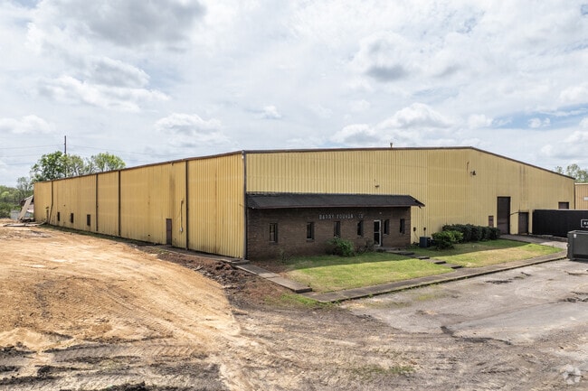
Property Record
3333 35Th Ave N, Birmingham, AL 35207

Current Lease Availabilities
NEARBY LISTINGS FOR SALE OR LEASE
Property Detail
3333 35Th Ave N
Birmingham-Hoover, AL
N Bham Re-L4a&5A 22-13-1
22-00-13-1-004-001.000
LOT 6-A RESUR LOTS 4-A & 5-A FAIRFIELD INCLUDING VACATED STREET 128/82
Miningfacilityoilgasmineralpreciousmetals
Jefferson
X
Alabama
01073C0391H
6-a
2023
2.60 AC
2024
Fultondale
005500
Birmingham
40,500 SF
DEMOGRAPHICS near 3333 35Th Ave N
1 Mile
3 Mile
5 Mile
2024 Total Population
3,800
35,888
122,903
2029 Population
3,764
36,224
122,997
Pop Growth 2024-2029
(0.95%)
+ 0.94%
+ 0.08%
Average Age
38
39
39
2024 Total Households
1,532
14,383
53,521
HH Growth 2024-2029
(0.59%)
+ 0.98%
+ 0.11%
Median Household Inc
$20,113
$29,983
$41,133
Avg Household Size
2.40
2.30
2.10
2024 Avg HH Vehicles
1.00
1.00
1.00
Median Home Value
$56,908
$76,631
$156,189
Median Year Built
1958
1964
1965
Nearby Places
Map Layers
Map Styles
 Street
 Aerial
- Restaurants
- Banks
- Shops
- Fitness
- Groceries
PUBLIC TRANSPORTATION
COMMUTER RAIL
Birmingham (Crescent - Amtrak)
DRIVE
WALK
Distance
Birmingham (Crescent - Amtrak)
9 min
4.5 mi
AIRPORT
Birmingham-Shuttlesworth International
DRIVE
WALK
Distance
Birmingham-Shuttlesworth International
12 min
5.4 mi
Freight Ports
Port of Mobile
DRIVE
WALK
Distance
Port of Mobile
287 min
260.2 mi
Nearby Properties
Address
Land Use
TOTAL SIZE
Lot Size
Zoning
Address
Land Use
TOTAL SIZE
Lot Size
Zoning
145,865 SF
142 AC
M1-M
Address
Land Use
TOTAL SIZE
Lot Size
Zoning
224,049 SF
4.33 AC
M1
Address
Land Use
TOTAL SIZE
Lot Size
Zoning
183,862 SF
9.66 AC
B4
Address
Land Use
TOTAL SIZE
Lot Size
Zoning
94,958 SF
4.47 AC
M1
Address
Land Use
TOTAL SIZE
Lot Size
Zoning
298,966 SF
73 AC
M1
Address
Land Use
TOTAL SIZE
Lot Size
Zoning
1.66 AC
M1-B
Address
Land Use
TOTAL SIZE
Lot Size
Zoning
29,136 SF
1.58 AC
B4
Address
Land Use
TOTAL SIZE
Lot Size
Zoning
37,733 SF
0.84 AC
B-4
Address
Land Use
TOTAL SIZE
Lot Size
Zoning
37,640 SF
1.76 AC
B4
Address
Land Use
TOTAL SIZE
Lot Size
Zoning
123,136 SF
4.59 AC
M2
Address
Land Use
TOTAL SIZE
Lot Size
Zoning
2.20 AC
M1
Address
Land Use
TOTAL SIZE
Lot Size
Zoning
Address
Land Use
TOTAL SIZE
Lot Size
Zoning
237,826 SF
12 AC
B3
Address
Land Use
TOTAL SIZE
Lot Size
Zoning
2,017,741 SF
37.70 AC
M2M1
Address
Land Use
TOTAL SIZE
Lot Size
Zoning
64,253 SF
1.09 AC
B4
Address
Land Use
TOTAL SIZE
Lot Size
Zoning
249,627 SF
5.29 AC
B4-M
Address
Land Use
TOTAL SIZE
Lot Size
Zoning
216,610 SF
20 AC
R3
Address
Land Use
TOTAL SIZE
Lot Size
Zoning
225,000 SF
14 AC
B-2
Address
Land Use
TOTAL SIZE
Lot Size
Zoning
345,035 SF
39 AC
M1
Address
Land Use
TOTAL SIZE
Lot Size
Zoning
87,159 SF
1.62 AC
B4
Address
Land Use
TOTAL SIZE
Lot Size
Zoning
96,102 SF
1.74 AC
B4
Address
Land Use
TOTAL SIZE
Lot Size
Zoning
89,915 SF
3.28 AC
M1
Address
Land Use
TOTAL SIZE
Lot Size
Zoning
39,731 SF
2.50 AC
M1
Address
Land Use
TOTAL SIZE
Lot Size
Zoning
186,000 SF
12.63 AC
QM1
Address
Land Use
TOTAL SIZE
Lot Size
Zoning
0.87 AC
B-4
Address
Land Use
TOTAL SIZE
Lot Size
Zoning
51,584 SF
1.10 AC
B4
Address
Land Use
TOTAL SIZE
Lot Size
Zoning
186,911 SF
12 AC
QM1
Address
Land Use
TOTAL SIZE
Lot Size
Zoning
140,000 SF
4.80 AC
M3
Address
Land Use
TOTAL SIZE
Lot Size
Zoning
113,147 SF
115 AC
M1
Address
Land Use
TOTAL SIZE
Lot Size
Zoning
108,813 SF
156 AC
M-1
The World's #1 Commercial Real Estate Marketplace
Connect with us
© 2025 CoStar Group
The information above has been obtained from sources believed reliable. While we do not doubt its accuracy we have not verified it and make no guarantee, warranty or representation about it. It is your responsibility to independently confirm its accuracy and completeness. Any projections, opinions, assumptions, or estimates used are for example only and do not represent the current or future performance of the property. The value of this transaction to you depends on tax and other factors which should be evaluated by your tax, financial, and legal advisors. You and your advisors should conduct a careful, independent investigation of the property to determine to your satisfaction the suitability of the property for your needs.