Property Record
3335 Us Highway 160, Reeds Spring, MO 65737
NEARBY LISTINGS FOR SALE OR LEASE
-
-
View all Reeds Spring listings for sale on LoopNet.com
Property Detail
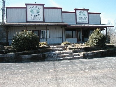
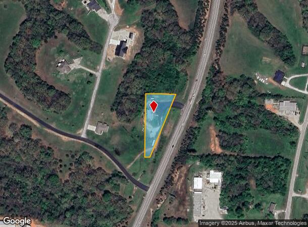
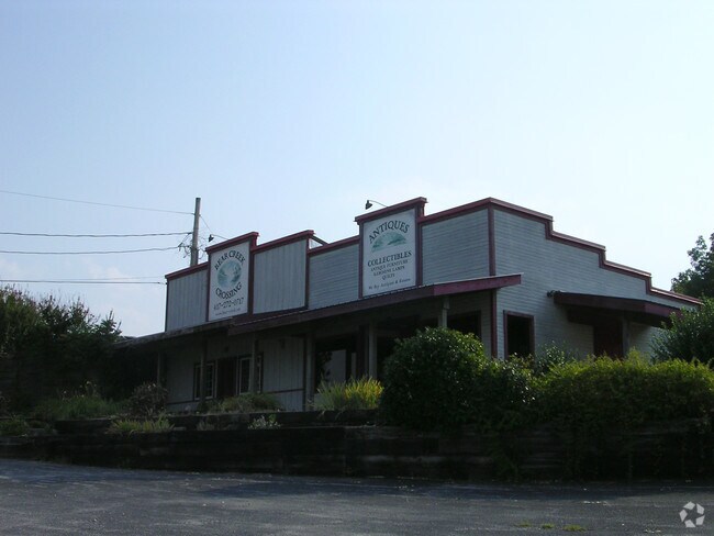
3335 Us Highway 160
07-4.0-18-000-000-003.002
COMMENCING AT THE SE CORNER OF THE SE1/4 OF THE SE1/4 OF SECTION 18; THENCE NW 398.21 FT, THENCE SW 1464.69 FT FOR A POINT OF BEGINNING; THENCE SW 32.64 FT,THENCE NW 392.2 FT, THENCE NE 184.55 FT, THENCE CURVE TO THE RIGHT BEARING SW 150.07 FT, THENC
Storemultistory
Stone
X
Missouri
29209C0150D
0.99 AC
2024
Branson
2025
Other Market Areas
090606
Branson, MO
1,615 SF
DEMOGRAPHICS near 3335 Us Highway 160
1 Mile
3 Mile
5 Mile
2024 Total Population
303
1,704
4,841
2029 Population
324
1,815
5,108
Pop Growth 2024-2029
+ 6.93%
+ 6.51%
+ 5.52%
Average Age
42
42
42
2024 Total Households
117
655
1,828
HH Growth 2024-2029
+ 5.98%
+ 5.80%
+ 4.92%
Median Household Inc
$59,999
$47,000
$54,794
Avg Household Size
2.40
2.50
2.50
2024 Avg HH Vehicles
2.00
2.00
2.00
Median Home Value
$222,727
$172,875
$198,213
Median Year Built
1992
1988
1992
Nearby Places
Map Layers
Map Styles
 Street
 Aerial
- Restaurants
- Banks
- Shops
- Fitness
- Groceries
PUBLIC TRANSPORTATION
AIRPORT
Springfield-Branson Ntl
DRIVE
WALK
Distance
Springfield-Branson Ntl
65 min
41.0 mi
Nearby Properties
Address
Land Use
TOTAL SIZE
Lot Size
Zoning
Address
Land Use
TOTAL SIZE
Lot Size
Zoning
9,064 SF
1.40 AC
RR-1
Address
Land Use
TOTAL SIZE
Lot Size
Zoning
3,321 SF
2.60 AC
R-1
Address
Land Use
TOTAL SIZE
Lot Size
Zoning
3,192 SF
3.50 AC
C-2
Address
Land Use
TOTAL SIZE
Lot Size
Zoning
1,600 SF
6.60 AC
A-1
Address
Land Use
TOTAL SIZE
Lot Size
Zoning
4,300 SF
1.25 AC
RR-1
Address
Land Use
TOTAL SIZE
Lot Size
Zoning
29,468 SF
15.36 AC
NA
Address
Land Use
TOTAL SIZE
Lot Size
Zoning
3,600 SF
3.50 AC
A-1
Address
Land Use
TOTAL SIZE
Lot Size
Zoning
29,180 SF
10.76 AC
C-2
Address
Land Use
TOTAL SIZE
Lot Size
Zoning
3,600 SF
0.26 AC
NA
Address
Land Use
TOTAL SIZE
Lot Size
Zoning
11,520 SF
1.60 AC
NA
Address
Land Use
TOTAL SIZE
Lot Size
Zoning
25,192 SF
5.33 AC
C-2
Address
Land Use
TOTAL SIZE
Lot Size
Zoning
14,934 SF
8.88 AC
C-2
Address
Land Use
TOTAL SIZE
Lot Size
Zoning
15,340 SF
2.90 AC
C-2
Address
Land Use
TOTAL SIZE
Lot Size
Zoning
2,401 SF
3.03 AC
C-2
Address
Land Use
TOTAL SIZE
Lot Size
Zoning
2,664 SF
0.73 AC
C-2
Address
Land Use
TOTAL SIZE
Lot Size
Zoning
4,600 SF
1.17 AC
A-1
Address
Land Use
TOTAL SIZE
Lot Size
Zoning
3,224 SF
0.80 AC
NA
Address
Land Use
TOTAL SIZE
Lot Size
Zoning
4,962 SF
0.77 AC
NA
Address
Land Use
TOTAL SIZE
Lot Size
Zoning
4,148 SF
0.39 AC
NA
Address
Land Use
TOTAL SIZE
Lot Size
Zoning
3,750 SF
2.19 AC
C-2
Address
Land Use
TOTAL SIZE
Lot Size
Zoning
5,182 SF
0.52 AC
NA
Address
Land Use
TOTAL SIZE
Lot Size
Zoning
2,400 SF
1.82 AC
NA
Address
Land Use
TOTAL SIZE
Lot Size
Zoning
3,840 SF
0.17 AC
NA
Address
Land Use
TOTAL SIZE
Lot Size
Zoning
5,040 SF
9.65 AC
C-2
Address
Land Use
TOTAL SIZE
Lot Size
Zoning
1,792 SF
0.35 AC
NA
Address
Land Use
TOTAL SIZE
Lot Size
Zoning
6,200 SF
2.70 AC
RR-1
Address
Land Use
TOTAL SIZE
Lot Size
Zoning
3,620 SF
5 AC
C-2
Address
Land Use
TOTAL SIZE
Lot Size
Zoning
1,520 SF
0.13 AC
NA
Address
Land Use
TOTAL SIZE
Lot Size
Zoning
5,440 SF
0.28 AC
NA
The World's #1 Commercial Real Estate Marketplace
Connect with us
© 2026 CoStar Group
The information above has been obtained from sources believed reliable. While we do not doubt its accuracy we have not verified it and make no guarantee, warranty or representation about it. It is your responsibility to independently confirm its accuracy and completeness. Any projections, opinions, assumptions, or estimates used are for example only and do not represent the current or future performance of the property. The value of this transaction to you depends on tax and other factors which should be evaluated by your tax, financial, and legal advisors. You and your advisors should conduct a careful, independent investigation of the property to determine to your satisfaction the suitability of the property for your needs.