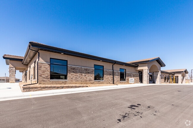
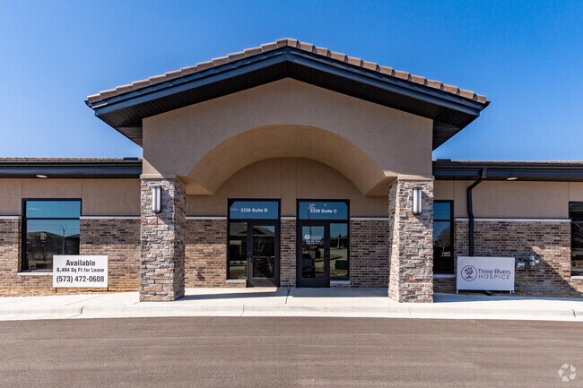
Property Record
3338 Ne Ralph Powell Rd, Lees Summit, MO 64064
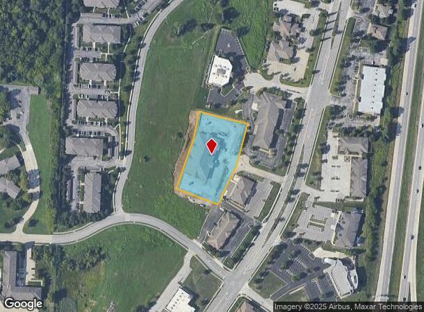
NEARBY LISTINGS FOR SALE OR LEASE
Property Detail
3338 Ne Ralph Powell Rd
43-840-03-27-00-0-00-000
5 And 5D
Officebuilding
CHAPEL RIDGE BUSINESS PARK LOT 4-K & 5-D---LOT 4-K
X
Jackson
29095C0430G
Missouri
2024
4
2025
East Jackson County
014205
Kansas City
18,000 SF
Kansas City, MO-KS
DEMOGRAPHICS near 3338 Ne Ralph Powell Rd
1 Mile
3 Mile
5 Mile
2024 Total Population
3,406
22,053
102,296
2029 Population
3,390
21,862
101,513
Pop Growth 2024-2029
(0.47%)
(0.87%)
(0.77%)
Average Age
40
41
41
2024 Total Households
1,342
8,304
41,031
HH Growth 2024-2029
(0.45%)
(0.96%)
(0.79%)
Median Household Inc
$69,148
$104,055
$86,340
Avg Household Size
2.40
2.60
2.40
2024 Avg HH Vehicles
2.00
2.00
2.00
Median Home Value
$258,755
$305,822
$253,218
Median Year Built
1989
1991
1986
Nearby Places
Map Layers
Map Styles
 Street
 Aerial
- Restaurants
- Banks
- Shops
- Fitness
- Groceries
PUBLIC TRANSPORTATION
COMMUTER RAIL
DRIVE
WALK
Distance
10 min
5.2 mi
AIRPORT
Kansas City International
DRIVE
WALK
Distance
Kansas City International
54 min
39.8 mi
Nearby Properties
Address
Land Use
TOTAL SIZE
Lot Size
Zoning
Address
Land Use
TOTAL SIZE
Lot Size
Zoning
474,121 SF
40.14 AC
Address
Land Use
TOTAL SIZE
Lot Size
Zoning
195,589 SF
47.72 AC
Address
Land Use
TOTAL SIZE
Lot Size
Zoning
523,783 SF
1.61 AC
Address
Land Use
TOTAL SIZE
Lot Size
Zoning
248,600 SF
Address
Land Use
TOTAL SIZE
Lot Size
Zoning
140,377 SF
27 AC
Address
Land Use
TOTAL SIZE
Lot Size
Zoning
96,980 SF
66.45 AC
Address
Land Use
TOTAL SIZE
Lot Size
Zoning
192,014 SF
20.95 AC
Address
Land Use
TOTAL SIZE
Lot Size
Zoning
108,530 SF
17.95 AC
Address
Land Use
TOTAL SIZE
Lot Size
Zoning
82,704 SF
148.69 AC
Address
Land Use
TOTAL SIZE
Lot Size
Zoning
128,393 SF
27.30 AC
Address
Land Use
TOTAL SIZE
Lot Size
Zoning
251,085 SF
Address
Land Use
TOTAL SIZE
Lot Size
Zoning
Address
Land Use
TOTAL SIZE
Lot Size
Zoning
12,788 SF
16.29 AC
Address
Land Use
TOTAL SIZE
Lot Size
Zoning
94,314 SF
20.02 AC
Address
Land Use
TOTAL SIZE
Lot Size
Zoning
22,500 SF
Address
Land Use
TOTAL SIZE
Lot Size
Zoning
33,136 SF
3.99 AC
Address
Land Use
TOTAL SIZE
Lot Size
Zoning
67,800 SF
2.53 AC
Address
Land Use
TOTAL SIZE
Lot Size
Zoning
87,599 SF
9.19 AC
Address
Land Use
TOTAL SIZE
Lot Size
Zoning
15,585 SF
5.39 AC
Address
Land Use
TOTAL SIZE
Lot Size
Zoning
43,075 SF
10.04 AC
Address
Land Use
TOTAL SIZE
Lot Size
Zoning
64,245 SF
10.05 AC
Address
Land Use
TOTAL SIZE
Lot Size
Zoning
69,312 SF
2.50 AC
Address
Land Use
TOTAL SIZE
Lot Size
Zoning
33,894 SF
3 AC
Address
Land Use
TOTAL SIZE
Lot Size
Zoning
13,573 SF
13.28 AC
Address
Land Use
TOTAL SIZE
Lot Size
Zoning
21,561 SF
4.37 AC
Address
Land Use
TOTAL SIZE
Lot Size
Zoning
36,627 SF
2.50 AC
Address
Land Use
TOTAL SIZE
Lot Size
Zoning
32,142 SF
10.77 AC
Address
Land Use
TOTAL SIZE
Lot Size
Zoning
13,852 SF
5.18 AC
Address
Land Use
TOTAL SIZE
Lot Size
Zoning
33,994 SF
9.72 AC
Address
Land Use
TOTAL SIZE
Lot Size
Zoning
90,842 SF
11.54 AC
The World's #1 Commercial Real Estate Marketplace
Connect with us
© 2026 CoStar Group
The information above has been obtained from sources believed reliable. While we do not doubt its accuracy we have not verified it and make no guarantee, warranty or representation about it. It is your responsibility to independently confirm its accuracy and completeness. Any projections, opinions, assumptions, or estimates used are for example only and do not represent the current or future performance of the property. The value of this transaction to you depends on tax and other factors which should be evaluated by your tax, financial, and legal advisors. You and your advisors should conduct a careful, independent investigation of the property to determine to your satisfaction the suitability of the property for your needs.