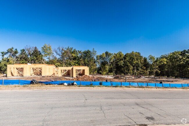
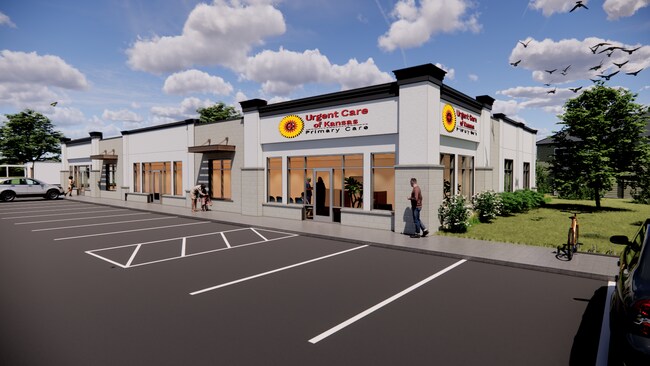
Property Record
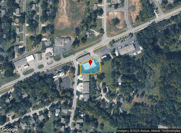
33391 Lexington Ave, De Soto, KS 66018
NEARBY LISTINGS FOR SALE OR LEASE
Property Detail
33391 Lexington Ave
Kansas City, MO-KS
Golden Lane Development
AF221228-4078
GOLDEN LANE DEVELOPMENT, LOT 1
Officebuilding
Johnson
AE
Kansas
20103C0425G
1
2024
0.64 AC
2024
Northwest Johnson County
052701
Kansas City
7,320 SF
DEMOGRAPHICS near 33391 Lexington Ave
1 Mile
3 Mile
5 Mile
2024 Total Population
4,062
6,768
11,230
2029 Population
4,271
7,092
11,707
Pop Growth 2024-2029
+ 5.15%
+ 4.79%
+ 4.25%
Average Age
39
40
42
2024 Total Households
1,474
2,511
4,154
HH Growth 2024-2029
+ 5.29%
+ 4.86%
+ 4.36%
Median Household Inc
$88,776
$93,877
$103,340
Avg Household Size
2.70
2.70
2.70
2024 Avg HH Vehicles
2.00
2.00
2.00
Median Home Value
$350,873
$380,526
$419,012
Median Year Built
1984
1987
1992
Nearby Places
Map Layers
Map Styles
 Street
 Aerial
- Restaurants
- Banks
- Shops
- Fitness
- Groceries
PUBLIC TRANSPORTATION
AIRPORT
Kansas City International
DRIVE
WALK
Distance
Kansas City International
57 min
42.6 mi
SALE & LEASE HISTORY
LISTING DATE
SALE/LEASE

Jun 26, 2023
For Lease
Nearby Properties
Address
Land Use
TOTAL SIZE
Lot Size
Zoning
Address
Land Use
TOTAL SIZE
Lot Size
Zoning
261,124 SF
28.29 AC
O-I
Address
Land Use
TOTAL SIZE
Lot Size
Zoning
2,785,348 SF
260.48 AC
M-1
Address
Land Use
TOTAL SIZE
Lot Size
Zoning
17,561 SF
6.91 AC
M-1
Address
Land Use
TOTAL SIZE
Lot Size
Zoning
186,690 SF
30.21 AC
O-I
Address
Land Use
TOTAL SIZE
Lot Size
Zoning
86,459 SF
17.20 AC
O-I
Address
Land Use
TOTAL SIZE
Lot Size
Zoning
1,016,186 SF
54.32 AC
RUR
Address
Land Use
TOTAL SIZE
Lot Size
Zoning
3,416 SF
3.20 AC
M-1
Address
Land Use
TOTAL SIZE
Lot Size
Zoning
57,788 SF
4.65 AC
O-I
Address
Land Use
TOTAL SIZE
Lot Size
Zoning
296,779 SF
146 AC
M-1
Address
Land Use
TOTAL SIZE
Lot Size
Zoning
436,551 SF
52.90 AC
M-1
Address
Land Use
TOTAL SIZE
Lot Size
Zoning
35,725 SF
9.52 AC
R-0
Address
Land Use
TOTAL SIZE
Lot Size
Zoning
2 AC
RUR
Address
Land Use
TOTAL SIZE
Lot Size
Zoning
117,822 SF
164.92 AC
M-1
Address
Land Use
TOTAL SIZE
Lot Size
Zoning
158.57 AC
RUR
Address
Land Use
TOTAL SIZE
Lot Size
Zoning
41.84 AC
M-1
Address
Land Use
TOTAL SIZE
Lot Size
Zoning
37.18 AC
Address
Land Use
TOTAL SIZE
Lot Size
Zoning
133,668 SF
11.62 AC
M-2
Address
Land Use
TOTAL SIZE
Lot Size
Zoning
1,206 SF
29.82 AC
Address
Land Use
TOTAL SIZE
Lot Size
Zoning
7,625 SF
4.54 AC
R-0
Address
Land Use
TOTAL SIZE
Lot Size
Zoning
99,750 SF
3.40 AC
M-2
Address
Land Use
TOTAL SIZE
Lot Size
Zoning
5,000 SF
20.03 AC
RUR
Address
Land Use
TOTAL SIZE
Lot Size
Zoning
10,620 SF
5.85 AC
R-1
Address
Land Use
TOTAL SIZE
Lot Size
Zoning
18,000 SF
3.39 AC
M-1
Address
Land Use
TOTAL SIZE
Lot Size
Zoning
16,868 SF
2.61 AC
C-2
Address
Land Use
TOTAL SIZE
Lot Size
Zoning
26.12 AC
RUR
Address
Land Use
TOTAL SIZE
Lot Size
Zoning
12,231 SF
0.82 AC
P-D
Address
Land Use
TOTAL SIZE
Lot Size
Zoning
77,519 SF
15.20 AC
M-1
Address
Land Use
TOTAL SIZE
Lot Size
Zoning
37,081 SF
5.46 AC
M-1
Address
Land Use
TOTAL SIZE
Lot Size
Zoning
19.57 AC
O-I
Address
Land Use
TOTAL SIZE
Lot Size
Zoning
46,024 SF
3.64 AC
M-1
The World's #1 Commercial Real Estate Marketplace
Connect with us
© 2025 CoStar Group
The information above has been obtained from sources believed reliable. While we do not doubt its accuracy we have not verified it and make no guarantee, warranty or representation about it. It is your responsibility to independently confirm its accuracy and completeness. Any projections, opinions, assumptions, or estimates used are for example only and do not represent the current or future performance of the property. The value of this transaction to you depends on tax and other factors which should be evaluated by your tax, financial, and legal advisors. You and your advisors should conduct a careful, independent investigation of the property to determine to your satisfaction the suitability of the property for your needs.