Property Record
332 Goldsby Rd, Santa Rosa Beach, FL 32459
NEARBY LISTINGS FOR SALE OR LEASE
-
-
View all Santa Rosa Beach listings for sale on LoopNet.com
Property Detail
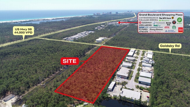
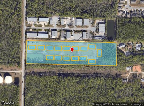
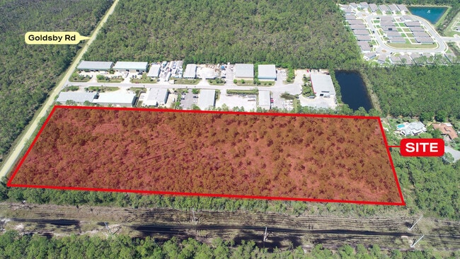
332 Goldsby Rd
Other Market Areas
Goldsby Road Commerce Park
Crestview-Fort Walton Beach-Destin, FL
Walton
30-2S-20-33230-000-0540
Florida
Residentialcommonelementscondominiumcorporation
10 AC
A
Florida Panhandle Area
12131C0543H
DEMOGRAPHICS near 332 Goldsby Rd
1 Mile
3 Mile
5 Mile
2024 Total Population
2,355
14,675
25,504
2029 Population
2,967
18,817
32,947
Pop Growth 2024-2029
+ 25.99%
+ 28.22%
+ 29.18%
Average Age
42
46
47
2024 Total Households
867
6,260
11,085
HH Growth 2024-2029
+ 26.64%
+ 29.36%
+ 30.33%
Median Household Inc
$73,623
$87,306
$78,793
Avg Household Size
2.40
2.20
2.20
2024 Avg HH Vehicles
2.00
2.00
2.00
Median Home Value
$582,326
$482,246
$464,752
Median Year Built
2003
2002
2001
Nearby Places
Map Layers
Map Styles
 Street
 Aerial
- Restaurants
- Banks
- Shops
- Fitness
- Groceries
PUBLIC TRANSPORTATION
AIRPORT
Eglin AFB/Destin-Ft Walton Beach
DRIVE
WALK
Distance
Eglin AFB/Destin-Ft Walton Beach
60 min
26.2 mi
Northwest Florida Beaches International
DRIVE
WALK
Distance
Northwest Florida Beaches International
60 min
40.4 mi
Freight Ports
Port of Panama City
DRIVE
WALK
Distance
Port of Panama City
59 min
38.7 mi
SALE & LEASE HISTORY
LISTING DATE
SALE/LEASE

May 08, 2023
For Lease
Aug 20, 2024
For Sale
Aug 18, 2023
For Sale
Nearby Properties
Address
Land Use
TOTAL SIZE
Lot Size
Zoning
Address
Land Use
TOTAL SIZE
Lot Size
Zoning
437,780 SF
9.40 AC
SD
Address
Land Use
TOTAL SIZE
Lot Size
Zoning
267,405 SF
1.54 AC
Address
Land Use
TOTAL SIZE
Lot Size
Zoning
269,575 SF
5.60 AC
SD
Address
Land Use
TOTAL SIZE
Lot Size
Zoning
399,449 SF
32.23 AC
SMNBHD
Address
Land Use
TOTAL SIZE
Lot Size
Zoning
164,747 SF
18.79 AC
Address
Land Use
TOTAL SIZE
Lot Size
Zoning
218,504 SF
11.87 AC
HWY 98
Address
Land Use
TOTAL SIZE
Lot Size
Zoning
195,860 SF
14.03 AC
HWY 98
Address
Land Use
TOTAL SIZE
Lot Size
Zoning
182,539 SF
2.60 AC
SD
Address
Land Use
TOTAL SIZE
Lot Size
Zoning
140,273 SF
30 AC
Address
Land Use
TOTAL SIZE
Lot Size
Zoning
205,627 SF
34.20 AC
HWY 98
Address
Land Use
TOTAL SIZE
Lot Size
Zoning
115,433 SF
0.96 AC
Address
Land Use
TOTAL SIZE
Lot Size
Zoning
97,373 SF
12.83 AC
HWY 98
Address
Land Use
TOTAL SIZE
Lot Size
Zoning
135,599 SF
1.21 AC
HWY 98
Address
Land Use
TOTAL SIZE
Lot Size
Zoning
9,534 SF
12.45 AC
BAYS
Address
Land Use
TOTAL SIZE
Lot Size
Zoning
87,959 SF
2.76 AC
HWY 98
Address
Land Use
TOTAL SIZE
Lot Size
Zoning
126,494 SF
7.99 AC
VMU
Address
Land Use
TOTAL SIZE
Lot Size
Zoning
70,631 SF
75.50 AC
Address
Land Use
TOTAL SIZE
Lot Size
Zoning
63,106 SF
7.73 AC
HWY 98
Address
Land Use
TOTAL SIZE
Lot Size
Zoning
114,921 SF
3.43 AC
HWY 98
Address
Land Use
TOTAL SIZE
Lot Size
Zoning
1,500 SF
241.13 AC
Address
Land Use
TOTAL SIZE
Lot Size
Zoning
18,731 SF
10.15 AC
GULFFR
Address
Land Use
TOTAL SIZE
Lot Size
Zoning
67,482 SF
5.77 AC
Address
Land Use
TOTAL SIZE
Lot Size
Zoning
71,106 SF
1 AC
Address
Land Use
TOTAL SIZE
Lot Size
Zoning
67,668 SF
1.56 AC
Address
Land Use
TOTAL SIZE
Lot Size
Zoning
112,780 SF
5.73 AC
VMU
Address
Land Use
TOTAL SIZE
Lot Size
Zoning
78,285 SF
10.07 AC
HWY 98
Address
Land Use
TOTAL SIZE
Lot Size
Zoning
68,849 SF
6.75 AC
HWY 98
Address
Land Use
TOTAL SIZE
Lot Size
Zoning
28,703 SF
0.78 AC
VMU
Address
Land Use
TOTAL SIZE
Lot Size
Zoning
Address
Land Use
TOTAL SIZE
Lot Size
Zoning
119,173 SF
245.14 AC
BAYS
The World's #1 Commercial Real Estate Marketplace
Connect with us
© 2026 CoStar Group
The information above has been obtained from sources believed reliable. While we do not doubt its accuracy we have not verified it and make no guarantee, warranty or representation about it. It is your responsibility to independently confirm its accuracy and completeness. Any projections, opinions, assumptions, or estimates used are for example only and do not represent the current or future performance of the property. The value of this transaction to you depends on tax and other factors which should be evaluated by your tax, financial, and legal advisors. You and your advisors should conduct a careful, independent investigation of the property to determine to your satisfaction the suitability of the property for your needs.