Property Record
334 S Curtis Rd, Milwaukee, WI 53214
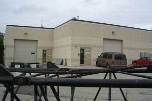

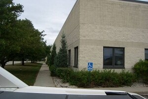
Property Detail
334 S Curtis Rd
Milwaukee-Waukesha, WI
CERTIFIED SURVEY MAP NO 6480 PARCEL 1 (1.201 AC) NW 1/4SEC 31-7-21
413-9999-037
MILWAUKEE
Commercialnec
Wisconsin
B and X Area of moderate flood hazard, usually the area between the limits of the 100-year and 500-year floods.
1.20 AC
2024
West Allis
2025
Milwaukee/Madison
100800
NEARBY LISTINGS FOR SALE OR LEASE
DEMOGRAPHICS near 334 S Curtis Rd
1 mile
3 mile
5 mile
2025 Total Population
8,259
84,329
261,080
2030 Population
8,268
85,000
261,623
Pop Growth 2025-2030
+ 0.11%
+ 0.80%
+ 0.21%
Average Age
42
41
41
2025 Total Households
3,648
37,465
114,397
HH Growth 2025-2030
+ 0.05%
+ 0.74%
+ 0.12%
Median Household Inc
$87,795
$84,132
$82,838
Avg Household Size
2.20
2.20
2.20
2025 Avg HH Vehicles
2.00
2.00
2.00
Median Home Value
$261,900
$288,788
$276,220
Median Year Built
1960
1959
1957
Nearby Places
Map Layers
Map Styles
 Street
 Aerial
Layers
 Traffic
 Biking
Places
Listings with unknown addresses are not visible on the map
- Restaurants
- Banks
- Shops
- Fitness
- Groceries
PUBLIC TRANSPORTATION
COMMUTER RAIL
Drive
Walk
Distance
15 min
8.8 mi
AIRPORT
General Mitchell International
Drive
Walk
Distance
General Mitchell International
25 min
13.5 mi
Freight Ports
Port Milwaukee
Drive
Walk
Distance
Port Milwaukee
20 min
11.3 mi
Nearby Properties
Address
Land Use
TOTAL SIZE
Lot Size
Zoning
Address
Land Use
TOTAL SIZE
Lot Size
Zoning
70.73 AC
Address
Land Use
TOTAL SIZE
Lot Size
Zoning
9.06 AC
SPMED
Address
Land Use
TOTAL SIZE
Lot Size
Zoning
8.63 AC
C2
Address
Land Use
TOTAL SIZE
Lot Size
Zoning
23.16 AC
Address
Land Use
TOTAL SIZE
Lot Size
Zoning
Address
Land Use
TOTAL SIZE
Lot Size
Zoning
Address
Land Use
TOTAL SIZE
Lot Size
Zoning
24.46 AC
Address
Land Use
TOTAL SIZE
Lot Size
Zoning
4.99 AC
Address
Land Use
TOTAL SIZE
Lot Size
Zoning
19.25 AC
Address
Land Use
TOTAL SIZE
Lot Size
Zoning
Address
Land Use
TOTAL SIZE
Lot Size
Zoning
4.54 AC
Address
Land Use
TOTAL SIZE
Lot Size
Zoning
102,604 SF
12.67 AC
PUD
Address
Land Use
TOTAL SIZE
Lot Size
Zoning
106,495 SF
9.70 AC
PUD
Address
Land Use
TOTAL SIZE
Lot Size
Zoning
5.12 AC
Address
Land Use
TOTAL SIZE
Lot Size
Zoning
17.45 AC
Address
Land Use
TOTAL SIZE
Lot Size
Zoning
Address
Land Use
TOTAL SIZE
Lot Size
Zoning
13.48 AC
Address
Land Use
TOTAL SIZE
Lot Size
Zoning
Address
Land Use
TOTAL SIZE
Lot Size
Zoning
2.97 AC
PUD
Address
Land Use
TOTAL SIZE
Lot Size
Zoning
29,664 SF
1.83 AC
C2
Address
Land Use
TOTAL SIZE
Lot Size
Zoning
230,726 SF
26.56 AC
RM1
Address
Land Use
TOTAL SIZE
Lot Size
Zoning
2.29 AC
INSTITUTIO
Address
Land Use
TOTAL SIZE
Lot Size
Zoning
4.79 AC
Address
Land Use
TOTAL SIZE
Lot Size
Zoning
4.53 AC
Address
Land Use
TOTAL SIZE
Lot Size
Zoning
Address
Land Use
TOTAL SIZE
Lot Size
Zoning
35.55 AC
INSTITUTIO
Address
Land Use
TOTAL SIZE
Lot Size
Zoning
Address
Land Use
TOTAL SIZE
Lot Size
Zoning
10.22 AC
SP-RP
Address
Land Use
TOTAL SIZE
Lot Size
Zoning
13.39 AC
Address
Land Use
TOTAL SIZE
Lot Size
Zoning
The World's #1 Commercial Real Estate Marketplace
Connect with us
© 2026 CoStar Group
The information above has been obtained from sources believed reliable. While we do not doubt its accuracy we have not verified it and make no guarantee, warranty or representation about it. It is your responsibility to independently confirm its accuracy and completeness. Any projections, opinions, assumptions, or estimates used are for example only and do not represent the current or future performance of the property. The value of this transaction to you depends on tax and other factors which should be evaluated by your tax, financial, and legal advisors. You and your advisors should conduct a careful, independent investigation of the property to determine to your satisfaction the suitability of the property for your needs.