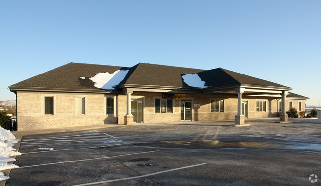
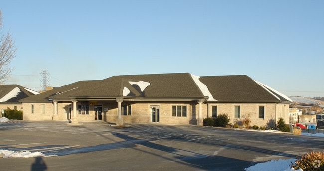
Property Record
3340 Emmaus Rd, Rockingham, VA 22801

Save to a Folder
{{folder.Name}}
{{folder.ListingIds.length}} Properties
{{folder.ListingIds.length}} Property
Create a New Folder
Property Detail
3340 Emmaus Rd
124D-6-L3
VALLEY PIKE EMMAUS SB DV L 3 S 1
Commercialnec
Rockingham
B1
Virginia
B and X Area of moderate flood hazard, usually the area between the limits of the 100-year and 500-year floods.
3
2026
0.94 AC
2026
Staunton & Harrisonburg
011400
Other Market Areas
23,276 SF
Harrisonburg, VA
NEARBY LISTINGS FOR SALE OR LEASE
DEMOGRAPHICS near 3340 Emmaus Rd
1 mile
3 mile
5 mile
2025 Total Population
1,117
28,006
75,462
2030 Population
1,160
28,482
76,569
Pop Growth 2025-2030
+ 3.85%
+ 1.70%
+ 1.47%
Average Age
34
33
35
2025 Total Households
363
9,242
25,918
HH Growth 2025-2030
+ 3.58%
+ 2.05%
+ 1.67%
Median Household Inc
$69,149
$65,012
$71,031
Avg Household Size
2.90
2.60
2.50
2025 Avg HH Vehicles
2.00
2.00
2.00
Median Home Value
$399,999
$351,055
$347,835
Median Year Built
1995
1993
1990
Nearby Places
Map Layers
Map Styles
 Street
 Aerial
Layers
 Traffic
 Biking
Places
Listings with unknown addresses are not visible on the map
- Restaurants
- Banks
- Shops
- Fitness
- Groceries
SALE & LEASE HISTORY
LISTING DATE
SALE/LEASE

Jun 13, 2018
For Sale
Nearby Properties
Address
Land Use
TOTAL SIZE
Lot Size
Zoning
Address
Land Use
TOTAL SIZE
Lot Size
Zoning
143.09 AC
MULTI DWEL
Address
Land Use
TOTAL SIZE
Lot Size
Zoning
126,552 SF
49.87 AC
GENERAL BU
Address
Land Use
TOTAL SIZE
Lot Size
Zoning
199.08 AC
I1
Address
Land Use
TOTAL SIZE
Lot Size
Zoning
57.92 AC
I1
Address
Land Use
TOTAL SIZE
Lot Size
Zoning
260,792 SF
27.98 AC
P1
Address
Land Use
TOTAL SIZE
Lot Size
Zoning
768 SF
62.46 AC
SINGLE FAM
Address
Land Use
TOTAL SIZE
Lot Size
Zoning
11.56 AC
B1
Address
Land Use
TOTAL SIZE
Lot Size
Zoning
225,360 SF
32.03 AC
I1
Address
Land Use
TOTAL SIZE
Lot Size
Zoning
14,490 SF
190 AC
PLANNED UN
Address
Land Use
TOTAL SIZE
Lot Size
Zoning
11.11 AC
R3
Address
Land Use
TOTAL SIZE
Lot Size
Zoning
130,426 SF
19.11 AC
R1
Address
Land Use
TOTAL SIZE
Lot Size
Zoning
295,544 SF
33.23 AC
I1
Address
Land Use
TOTAL SIZE
Lot Size
Zoning
9,440 SF
17.31 AC
R3
Address
Land Use
TOTAL SIZE
Lot Size
Zoning
6.10 AC
PMF
Address
Land Use
TOTAL SIZE
Lot Size
Zoning
119,941 SF
10.82 AC
SINGLE FAM
Address
Land Use
TOTAL SIZE
Lot Size
Zoning
905,216 SF
26.54 AC
M1
Address
Land Use
TOTAL SIZE
Lot Size
Zoning
15,432 SF
132 AC
MULTI DWEL
Address
Land Use
TOTAL SIZE
Lot Size
Zoning
13,578 SF
180 AC
HIGH DENSI
Address
Land Use
TOTAL SIZE
Lot Size
Zoning
15,432 SF
108 AC
MULTI DWEL
Address
Land Use
TOTAL SIZE
Lot Size
Zoning
25,020 SF
3.80 AC
COMMERCIAL
Address
Land Use
TOTAL SIZE
Lot Size
Zoning
13,986 SF
9.87 AC
R3
Address
Land Use
TOTAL SIZE
Lot Size
Zoning
15,244 SF
7.01 AC
R4
Address
Land Use
TOTAL SIZE
Lot Size
Zoning
84,000 SF
17 AC
GENERAL IN
Address
Land Use
TOTAL SIZE
Lot Size
Zoning
153,181 SF
19.26 AC
B1
Address
Land Use
TOTAL SIZE
Lot Size
Zoning
348,801 SF
26.90 AC
I1
Address
Land Use
TOTAL SIZE
Lot Size
Zoning
172,195 SF
4.24 AC
B1
Address
Land Use
TOTAL SIZE
Lot Size
Zoning
2,145 SF
2.71 AC
PMF
Address
Land Use
TOTAL SIZE
Lot Size
Zoning
13,440 SF
96 AC
PLANNED UN
Address
Land Use
TOTAL SIZE
Lot Size
Zoning
21.42 AC
I1
Address
Land Use
TOTAL SIZE
Lot Size
Zoning
14,700 SF
84 AC
MULTI DWEL
The World's #1 Commercial Real Estate Marketplace
Connect with us
© 2026 CoStar Group
The information above has been obtained from sources believed reliable. While we do not doubt its accuracy we have not verified it and make no guarantee, warranty or representation about it. It is your responsibility to independently confirm its accuracy and completeness. Any projections, opinions, assumptions, or estimates used are for example only and do not represent the current or future performance of the property. The value of this transaction to you depends on tax and other factors which should be evaluated by your tax, financial, and legal advisors. You and your advisors should conduct a careful, independent investigation of the property to determine to your satisfaction the suitability of the property for your needs.