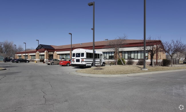
Property Record
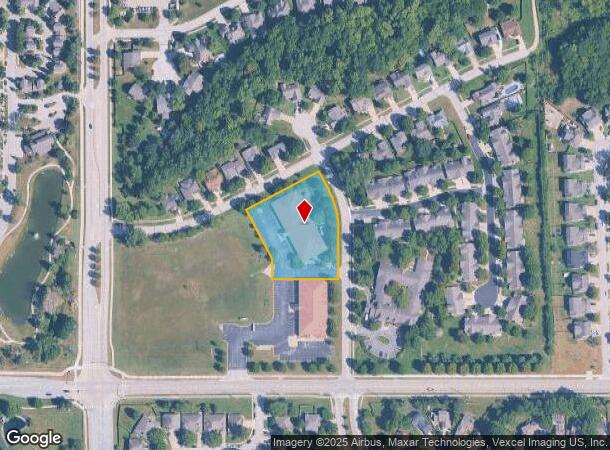
3340 Peterson Rd, Lawrence, KS 66049

NEARBY LISTINGS FOR SALE OR LEASE
Property Detail
3340 Peterson Rd
Lawrence, KS
Deerfield Woods Subdivision No 10
023-066-23-0-30-11-001.00-0
DEEDEERFIELD WOODS SUB NO 10 BLK 1 LT 2 (REPLAT 2015)
Officebuilding
Douglas
X
Kansas
20045C0157E
2
2025
1.48 AC
2025
Lawrence
000604
Kansas City
16,000 SF
DEMOGRAPHICS near 3340 Peterson Rd
1 Mile
3 Mile
5 Mile
2024 Total Population
7,827
56,992
96,503
2029 Population
7,938
58,079
98,473
Pop Growth 2024-2029
+ 1.42%
+ 1.91%
+ 2.04%
Average Age
40
35
36
2024 Total Households
3,274
23,347
40,592
HH Growth 2024-2029
+ 1.47%
+ 2.15%
+ 2.23%
Median Household Inc
$83,505
$57,464
$54,712
Avg Household Size
2.40
2.10
2.20
2024 Avg HH Vehicles
2.00
2.00
2.00
Median Home Value
$258,164
$279,039
$239,158
Median Year Built
1994
1989
1988
Nearby Places
Map Layers
Map Styles
 Street
 Aerial
- Restaurants
- Banks
- Shops
- Fitness
- Groceries
PUBLIC TRANSPORTATION
COMMUTER RAIL
DRIVE
WALK
Distance
8 min
4.1 mi
SALE & LEASE HISTORY
LISTING DATE
SALE/LEASE

Mar 22, 2017
For Sale
Nearby Properties
Address
Land Use
TOTAL SIZE
Lot Size
Zoning
Address
Land Use
TOTAL SIZE
Lot Size
Zoning
1,709,524 SF
32.03 AC
RD
Address
Land Use
TOTAL SIZE
Lot Size
Zoning
1,258,819 SF
106.65 AC
RD
Address
Land Use
TOTAL SIZE
Lot Size
Zoning
1,264,810 SF
129.10 AC
RD
Address
Land Use
TOTAL SIZE
Lot Size
Zoning
63,837 SF
20.79 AC
H
Address
Land Use
TOTAL SIZE
Lot Size
Zoning
335,349 SF
3.17 AC
RD
Address
Land Use
TOTAL SIZE
Lot Size
Zoning
112,168 SF
38.08 AC
RD
Address
Land Use
TOTAL SIZE
Lot Size
Zoning
200,960 SF
9.20 AC
RD
Address
Land Use
TOTAL SIZE
Lot Size
Zoning
190,168 SF
55.04 AC
C2
Address
Land Use
TOTAL SIZE
Lot Size
Zoning
336,701 SF
5.20 AC
RD
Address
Land Use
TOTAL SIZE
Lot Size
Zoning
112,500 SF
3.90 AC
RM1
Address
Land Use
TOTAL SIZE
Lot Size
Zoning
47,457 SF
2.58 AC
Address
Land Use
TOTAL SIZE
Lot Size
Zoning
220,557 SF
8.90 AC
RD
Address
Land Use
TOTAL SIZE
Lot Size
Zoning
162,086 SF
3 AC
RD
Address
Land Use
TOTAL SIZE
Lot Size
Zoning
67,500 SF
4.03 AC
RM1
Address
Land Use
TOTAL SIZE
Lot Size
Zoning
181,346 SF
21.40 AC
497
Address
Land Use
TOTAL SIZE
Lot Size
Zoning
186,889 SF
3.60 AC
RD
Address
Land Use
TOTAL SIZE
Lot Size
Zoning
92,295 SF
10.40 AC
RS1
Address
Land Use
TOTAL SIZE
Lot Size
Zoning
138,043 SF
26.20 AC
AG
Address
Land Use
TOTAL SIZE
Lot Size
Zoning
104,785 SF
105.60 AC
RS1
Address
Land Use
TOTAL SIZE
Lot Size
Zoning
56,172 SF
14.05 AC
AG
Address
Land Use
TOTAL SIZE
Lot Size
Zoning
92,819 SF
3.10 AC
RO2
Address
Land Use
TOTAL SIZE
Lot Size
Zoning
52,000 SF
36 AC
RS1
Address
Land Use
TOTAL SIZE
Lot Size
Zoning
19,985 SF
103.37 AC
RS1
Address
Land Use
TOTAL SIZE
Lot Size
Zoning
337,280 SF
0.60 AC
RD
Address
Land Use
TOTAL SIZE
Lot Size
Zoning
31,750 SF
0.73 AC
Address
Land Use
TOTAL SIZE
Lot Size
Zoning
34,479 SF
1.08 AC
C4
Address
Land Use
TOTAL SIZE
Lot Size
Zoning
131,625 SF
2.32 AC
C3
Address
Land Use
TOTAL SIZE
Lot Size
Zoning
51,366 SF
15 AC
RS2
Address
Land Use
TOTAL SIZE
Lot Size
Zoning
24,600 SF
8.90 AC
M3
Address
Land Use
TOTAL SIZE
Lot Size
Zoning
53,064 SF
5.79 AC
M2
The World's #1 Commercial Real Estate Marketplace
Connect with us
© 2026 CoStar Group
The information above has been obtained from sources believed reliable. While we do not doubt its accuracy we have not verified it and make no guarantee, warranty or representation about it. It is your responsibility to independently confirm its accuracy and completeness. Any projections, opinions, assumptions, or estimates used are for example only and do not represent the current or future performance of the property. The value of this transaction to you depends on tax and other factors which should be evaluated by your tax, financial, and legal advisors. You and your advisors should conduct a careful, independent investigation of the property to determine to your satisfaction the suitability of the property for your needs.