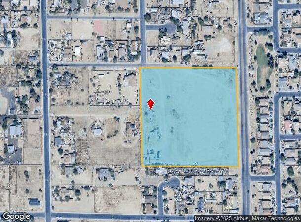
Property Record
3344 S El Mirage Rd, Avondale, AZ 85323
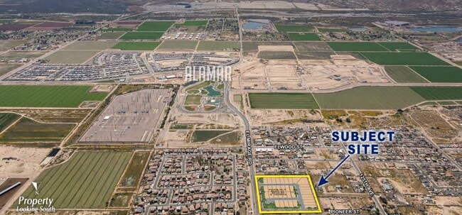
This Property Is For Sale
NEARBY LISTINGS FOR SALE OR LEASE
Property Detail
3344 S El Mirage Rd
Phoenix-Mesa-Scottsdale, AZ
Maricopa
500-65-144A
Arizona
Sfr
9.62 AC
X
Glendale
04013C2165P
Phoenix
2,511 SF
DEMOGRAPHICS near 3344 S El Mirage Rd
1 Mile
3 Mile
5 Mile
2024 Total Population
6,968
69,023
155,553
2029 Population
7,513
74,786
168,928
Pop Growth 2024-2029
+ 7.82%
+ 8.35%
+ 8.60%
Average Age
32
32
33
2024 Total Households
1,761
19,299
46,181
HH Growth 2024-2029
+ 7.95%
+ 8.51%
+ 8.75%
Median Household Inc
$86,967
$72,217
$75,798
Avg Household Size
3.90
3.50
3.30
2024 Avg HH Vehicles
3.00
2.00
2.00
Median Home Value
$339,115
$295,445
$315,509
Median Year Built
2007
2003
2003
Nearby Places
Map Layers
Map Styles
 Street
 Aerial
- Restaurants
- Banks
- Shops
- Fitness
- Groceries
PUBLIC TRANSPORTATION
AIRPORT
Phoenix Sky Harbor International
DRIVE
WALK
Distance
Phoenix Sky Harbor International
34 min
23.7 mi
Freight Ports
Port of San Diego
DRIVE
WALK
Distance
Port of San Diego
384 min
343.3 mi
Nearby Properties
Address
Land Use
TOTAL SIZE
Lot Size
Zoning
Address
Land Use
TOTAL SIZE
Lot Size
Zoning
12.80 AC
Address
Land Use
TOTAL SIZE
Lot Size
Zoning
206.08 AC
PAD
Address
Land Use
TOTAL SIZE
Lot Size
Zoning
487,354 SF
188.22 AC
PAD
Address
Land Use
TOTAL SIZE
Lot Size
Zoning
90,008 SF
20.42 AC
M-H
Address
Land Use
TOTAL SIZE
Lot Size
Zoning
418,000 SF
23.58 AC
I-1
Address
Land Use
TOTAL SIZE
Lot Size
Zoning
270,919 SF
281.46 AC
MSED
Address
Land Use
TOTAL SIZE
Lot Size
Zoning
901,699 SF
49.92 AC
I1
Address
Land Use
TOTAL SIZE
Lot Size
Zoning
301,329 SF
50.60 AC
AG
Address
Land Use
TOTAL SIZE
Lot Size
Zoning
369,413 SF
16.39 AC
THEBLVDD
Address
Land Use
TOTAL SIZE
Lot Size
Zoning
797,310 SF
36.82 AC
I-1
Address
Land Use
TOTAL SIZE
Lot Size
Zoning
78 AC
AG
Address
Land Use
TOTAL SIZE
Lot Size
Zoning
450,619 SF
28.95 AC
I2
Address
Land Use
TOTAL SIZE
Lot Size
Zoning
191,303 SF
37.42 AC
R-6
Address
Land Use
TOTAL SIZE
Lot Size
Zoning
1,038,407 SF
59.55 AC
R-43
Address
Land Use
TOTAL SIZE
Lot Size
Zoning
291,805 SF
16.48 AC
PAD
Address
Land Use
TOTAL SIZE
Lot Size
Zoning
90,516 SF
18.66 AC
R-6
Address
Land Use
TOTAL SIZE
Lot Size
Zoning
174,400 SF
17.83 AC
PCD
Address
Land Use
TOTAL SIZE
Lot Size
Zoning
60,562 SF
597.40 AC
AG
Address
Land Use
TOTAL SIZE
Lot Size
Zoning
450,240 SF
25.56 AC
Address
Land Use
TOTAL SIZE
Lot Size
Zoning
285,131 SF
16.11 AC
I-1
Address
Land Use
TOTAL SIZE
Lot Size
Zoning
299,050 SF
16.29 AC
A1
Address
Land Use
TOTAL SIZE
Lot Size
Zoning
93,605 SF
10.99 AC
PAD
Address
Land Use
TOTAL SIZE
Lot Size
Zoning
389,952 SF
22.15 AC
Address
Land Use
TOTAL SIZE
Lot Size
Zoning
291,596 SF
18.32 AC
PAD
Address
Land Use
TOTAL SIZE
Lot Size
Zoning
139,126 SF
15.10 AC
R-6
Address
Land Use
TOTAL SIZE
Lot Size
Zoning
321,892 SF
18.64 AC
CPGCP
Address
Land Use
TOTAL SIZE
Lot Size
Zoning
300,100 SF
17.52 AC
Address
Land Use
TOTAL SIZE
Lot Size
Zoning
90,559 SF
13.43 AC
R-43AG
Address
Land Use
TOTAL SIZE
Lot Size
Zoning
91,648 SF
7.46 AC
PAD
Address
Land Use
TOTAL SIZE
Lot Size
Zoning
85,593 SF
13.76 AC
PAD
The World's #1 Commercial Real Estate Marketplace
Connect with us
© 2026 CoStar Group
The information above has been obtained from sources believed reliable. While we do not doubt its accuracy we have not verified it and make no guarantee, warranty or representation about it. It is your responsibility to independently confirm its accuracy and completeness. Any projections, opinions, assumptions, or estimates used are for example only and do not represent the current or future performance of the property. The value of this transaction to you depends on tax and other factors which should be evaluated by your tax, financial, and legal advisors. You and your advisors should conduct a careful, independent investigation of the property to determine to your satisfaction the suitability of the property for your needs.