Property Record
3351 Bridge Rd, Suffolk, VA 23435
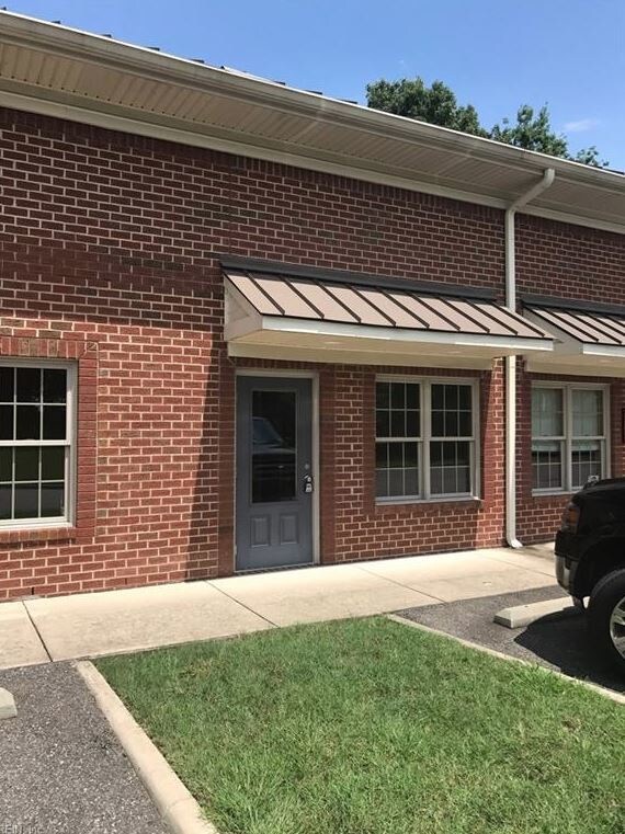

Property Detail
3351 Bridge Rd
306001304
PAR.A,GEO K EBERWINE JR PLAT,RT.17
Commercialnec
SUFFOLK CITY
OFFICE-INS
Virginia
AE The base floodplain where base flood elevations are provided. AE Zones are now used on new format FIRMs instead of A1-A30 Zones.
11.83 AC
2025
Harbourview/N Suffolk
2025
Hampton Roads
075203
Virginia Beach-Chesapeake-Norfolk, VA-NC
NEARBY LISTINGS FOR SALE OR LEASE
DEMOGRAPHICS near 3351 Bridge Rd
1 mile
3 mile
5 mile
2025 Total Population
4,831
28,631
79,900
2030 Population
5,334
30,973
83,536
Pop Growth 2025-2030
+ 10.41%
+ 8.18%
+ 4.55%
Average Age
39
40
39
2025 Total Households
1,733
10,848
30,133
HH Growth 2025-2030
+ 10.62%
+ 8.35%
+ 4.68%
Median Household Inc
$116,666
$102,313
$97,539
Avg Household Size
2.70
2.60
2.60
2025 Avg HH Vehicles
2.00
2.00
2.00
Median Home Value
$431,408
$405,745
$381,215
Median Year Built
2008
2003
1993
Nearby Places
Map Layers
Map Styles
 Street
 Aerial
Layers
 Traffic
 Biking
Places
Listings with unknown addresses are not visible on the map
- Restaurants
- Banks
- Shops
- Fitness
- Groceries
PUBLIC TRANSPORTATION
AIRPORT
Norfolk International
Drive
Walk
Distance
Norfolk International
32 min
17.9 mi
Newport News/Williamsburg International
Drive
Walk
Distance
Newport News/Williamsburg International
38 min
27.3 mi
Freight Ports
Virginia Port Authority - Portsmouth
Drive
Walk
Distance
Virginia Port Authority - Portsmouth
18 min
10.0 mi
SALE & LEASE HISTORY
LISTING DATE
SALE/LEASE

Aug 24, 2018
For Sale
Aug 05, 2017
For Sale
Nearby Properties
Address
Land Use
TOTAL SIZE
Lot Size
Zoning
Address
Land Use
TOTAL SIZE
Lot Size
Zoning
13.52 AC
MIXED USE
Address
Land Use
TOTAL SIZE
Lot Size
Zoning
4,080 SF
41.46 AC
LIGHT INDU
Address
Land Use
TOTAL SIZE
Lot Size
Zoning
30.85 AC
PLANNED DE
Address
Land Use
TOTAL SIZE
Lot Size
Zoning
6,446 SF
8.76 AC
MIXED USE
Address
Land Use
TOTAL SIZE
Lot Size
Zoning
97,411 SF
17.90 AC
GENERAL CO
Address
Land Use
TOTAL SIZE
Lot Size
Zoning
22,723 SF
10.97 AC
GENERAL CO
Address
Land Use
TOTAL SIZE
Lot Size
Zoning
166,481 SF
11.15 AC
OFFICE-INS
Address
Land Use
TOTAL SIZE
Lot Size
Zoning
15,746 SF
24.70 AC
GENERAL CO
Address
Land Use
TOTAL SIZE
Lot Size
Zoning
71,769 SF
20.80 AC
RES LOW-ME
Address
Land Use
TOTAL SIZE
Lot Size
Zoning
126,000 SF
21.51 AC
LIGHT INDU
Address
Land Use
TOTAL SIZE
Lot Size
Zoning
222,810 SF
42.16 AC
MULTI: MUL
Address
Land Use
TOTAL SIZE
Lot Size
Zoning
6,788 SF
19.93 AC
GENERAL CO
Address
Land Use
TOTAL SIZE
Lot Size
Zoning
98,964 SF
13.57 AC
PLANNED DE
Address
Land Use
TOTAL SIZE
Lot Size
Zoning
29,060 SF
14.75 AC
RESIDENTIA
Address
Land Use
TOTAL SIZE
Lot Size
Zoning
49,736 SF
3.32 AC
MIXED USE
Address
Land Use
TOTAL SIZE
Lot Size
Zoning
91,005 SF
26.77 AC
M1: LIGHT
Address
Land Use
TOTAL SIZE
Lot Size
Zoning
6,170 SF
13.38 AC
GENERAL CO
Address
Land Use
TOTAL SIZE
Lot Size
Zoning
12.47 AC
RESIDENTIA
Address
Land Use
TOTAL SIZE
Lot Size
Zoning
119,232 SF
7.22 AC
M1: LIGHT
Address
Land Use
TOTAL SIZE
Lot Size
Zoning
11,255 SF
14.62 AC
GENERAL CO
Address
Land Use
TOTAL SIZE
Lot Size
Zoning
130,000 SF
12.33 AC
LIGHT INDU
Address
Land Use
TOTAL SIZE
Lot Size
Zoning
5.45 AC
GENERAL CO
The World's #1 Commercial Real Estate Marketplace
Connect with us
© 2026 CoStar Group
The information above has been obtained from sources believed reliable. While we do not doubt its accuracy we have not verified it and make no guarantee, warranty or representation about it. It is your responsibility to independently confirm its accuracy and completeness. Any projections, opinions, assumptions, or estimates used are for example only and do not represent the current or future performance of the property. The value of this transaction to you depends on tax and other factors which should be evaluated by your tax, financial, and legal advisors. You and your advisors should conduct a careful, independent investigation of the property to determine to your satisfaction the suitability of the property for your needs.