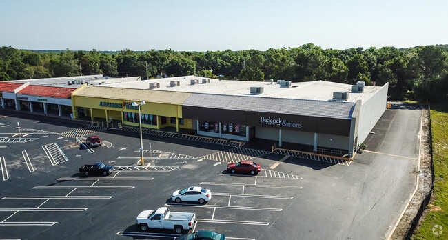
Property Record
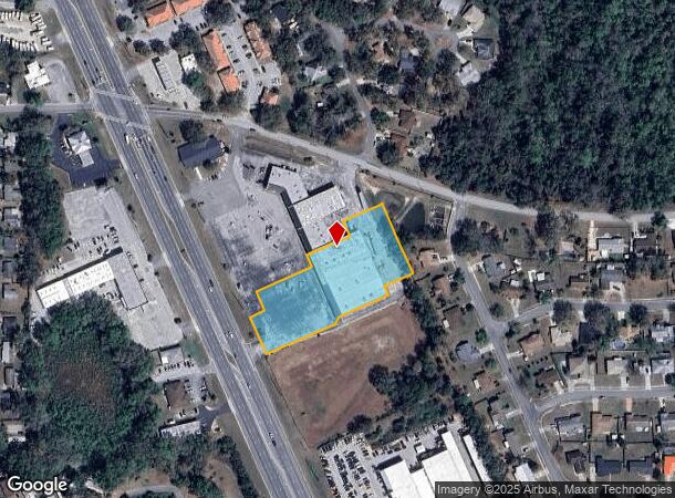
3345 Us Highway 441/27, Fruitland Park, FL 34731
NEARBY LISTINGS FOR SALE OR LEASE
Property Detail
3345 Us Highway 441/27
10-19-24-0003-000-07300
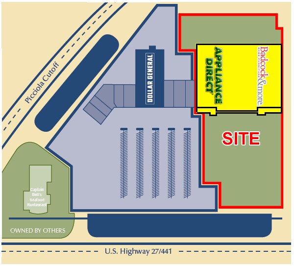
FROM INTERSECTION OF SLY R/W LINE OF PICCIOLA CUTOFF & ELY R/W LINE OF US HWY 441 RUN S 24-01-34 E ALONG SAID ELY R/W LINE 669.79 FT FOR POB RUN N 65-59-20 E 47.83 FT N 24-01-34 W 66.03 FT N 66-49-39 E 189.94 FT N 24-01-34 W 36.82 FT N 66-04-55 E 146
Stripcommercialcenter
Lake
X
Florida
12069C0307E
73
2024
2.43 AC
2026
Lake County
030601
Orlando
35,989 SF
Orlando-Kissimmee-Sanford, FL
DEMOGRAPHICS near 3345 Us Highway 441/27
1 Mile
3 Mile
5 Mile
2024 Total Population
5,590
29,708
73,802
2029 Population
6,532
34,721
88,461
Pop Growth 2024-2029
+ 16.85%
+ 16.87%
+ 19.86%
Average Age
44
46
53
2024 Total Households
2,447
12,846
34,513
HH Growth 2024-2029
+ 16.84%
+ 16.78%
+ 20.59%
Median Household Inc
$38,085
$45,986
$56,822
Avg Household Size
2.30
2.30
2.10
2024 Avg HH Vehicles
2.00
2.00
1.00
Median Home Value
$115,879
$208,294
$273,037
Median Year Built
1981
1984
2000
Nearby Places
Map Layers
Map Styles
 Street
 Aerial
- Restaurants
- Banks
- Shops
- Fitness
- Groceries
SALE & LEASE HISTORY
LISTING DATE
SALE/LEASE

Sep 25, 2016
For Lease
Sep 23, 2016
For Sale
Nearby Properties
Address
Land Use
TOTAL SIZE
Lot Size
Zoning
Address
Land Use
TOTAL SIZE
Lot Size
Zoning
131,225 SF
12.61 AC
Address
Land Use
TOTAL SIZE
Lot Size
Zoning
97,310 SF
154.74 AC
Address
Land Use
TOTAL SIZE
Lot Size
Zoning
126,140 SF
11.24 AC
C3
Address
Land Use
TOTAL SIZE
Lot Size
Zoning
2,000 SF
57.83 AC
P
Address
Land Use
TOTAL SIZE
Lot Size
Zoning
75,514 SF
4.49 AC
A
Address
Land Use
TOTAL SIZE
Lot Size
Zoning
100,330 SF
11.81 AC
A
Address
Land Use
TOTAL SIZE
Lot Size
Zoning
88,611 SF
112.12 AC
R1
Address
Land Use
TOTAL SIZE
Lot Size
Zoning
94,707 SF
16.79 AC
C3
Address
Land Use
TOTAL SIZE
Lot Size
Zoning
151,588 SF
16.62 AC
A
Address
Land Use
TOTAL SIZE
Lot Size
Zoning
190,537 SF
10.36 AC
C3
Address
Land Use
TOTAL SIZE
Lot Size
Zoning
51,662 SF
13.88 AC
A
Address
Land Use
TOTAL SIZE
Lot Size
Zoning
79,456 SF
9.44 AC
C3
Address
Land Use
TOTAL SIZE
Lot Size
Zoning
144,336 SF
18.32 AC
R3
Address
Land Use
TOTAL SIZE
Lot Size
Zoning
5,886 SF
19.13 AC
R2
Address
Land Use
TOTAL SIZE
Lot Size
Zoning
35,116 SF
3.18 AC
C3
Address
Land Use
TOTAL SIZE
Lot Size
Zoning
2,000 SF
31.75 AC
PUD
Address
Land Use
TOTAL SIZE
Lot Size
Zoning
40,811 SF
2.56 AC
CIP
Address
Land Use
TOTAL SIZE
Lot Size
Zoning
146,773 SF
5.05 AC
P
Address
Land Use
TOTAL SIZE
Lot Size
Zoning
59,664 SF
2.33 AC
C3
Address
Land Use
TOTAL SIZE
Lot Size
Zoning
35,568 SF
2.87 AC
C3
Address
Land Use
TOTAL SIZE
Lot Size
Zoning
25,673 SF
135.11 AC
A
Address
Land Use
TOTAL SIZE
Lot Size
Zoning
90,719 SF
7.55 AC
C3
Address
Land Use
TOTAL SIZE
Lot Size
Zoning
32,594 SF
8.37 AC
C2
Address
Land Use
TOTAL SIZE
Lot Size
Zoning
38,683 SF
4.52 AC
IND
Address
Land Use
TOTAL SIZE
Lot Size
Zoning
87,646 SF
6.84 AC
C3
Address
Land Use
TOTAL SIZE
Lot Size
Zoning
40,068 SF
3.08 AC
R3
Address
Land Use
TOTAL SIZE
Lot Size
Zoning
73,722 SF
8.31 AC
C2
Address
Land Use
TOTAL SIZE
Lot Size
Zoning
32,502 SF
5.16 AC
C3
Address
Land Use
TOTAL SIZE
Lot Size
Zoning
63,805 SF
4.25 AC
C2
Address
Land Use
TOTAL SIZE
Lot Size
Zoning
20,000 SF
2.01 AC
C3
The World's #1 Commercial Real Estate Marketplace
Connect with us
© 2025 CoStar Group
The information above has been obtained from sources believed reliable. While we do not doubt its accuracy we have not verified it and make no guarantee, warranty or representation about it. It is your responsibility to independently confirm its accuracy and completeness. Any projections, opinions, assumptions, or estimates used are for example only and do not represent the current or future performance of the property. The value of this transaction to you depends on tax and other factors which should be evaluated by your tax, financial, and legal advisors. You and your advisors should conduct a careful, independent investigation of the property to determine to your satisfaction the suitability of the property for your needs.